Jewell, Oregon

Last updated
Jewell, Oregon
Jewell Hotel & Store.png
The Jewell Hotel & Store, which burned at an unknown date. A pool hall can be seen in the distance on the left.
USA Oregon location map.svg
Red pog.svg
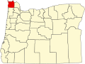
Jewell
Location within the state of Oregon
Coordinates: 45°56′04″N123°30′14″W / 45.93444°N 123.50389°W / 45.93444; -123.50389 Coordinates: 45°56′04″N123°30′14″W / 45.93444°N 123.50389°W / 45.93444; -123.50389
Country United States
State Oregon
County Clatsop
Named for Marshall Jewell
Area
  Total299.8 sq mi (776.5 km2)
Elevation
680 ft (210 m)
Population
 (2007)
  Total994
  Density3.3/sq mi (1.3/km2)
 [ citation needed ]
Time zone UTC-8 (Pacific (PST))
  Summer (DST) UTC-7 (PDT)
ZIP code
97138
Area codes 503 and 971

Jewell is an unincorporated community in Clatsop County, Oregon, United States. [1] The logging community is located at the junction of Oregon Route 103 and Oregon Route 202, near the Nehalem River.

Contents

History

Jewell, Oregon is named after Marshall Jewell, former United States Postmaster General Marshall Jewell - Brady-Handy.jpg
Jewell, Oregon is named after Marshall Jewell, former United States Postmaster General

Jewell was named after Marshall Jewell, United States Postmaster General from 1874–1876. A post office was established in Jewell in 1874 and closed in 1967. [2]

Natural history

Jewell is situated near the Clatsop State Forest. Jewell Meadows Wildlife Area is a wildlife preserve near Jewell run by the Oregon Department of Fish and Wildlife. It is known for its Roosevelt elk.

The world's largest Bigleaf Maple, as determined by the National Register of Big Trees, with a height of 101 feet and a spread of 90 feet, was located near Jewell, [3] [4] but fell during a windstorm in 2011. [5]

Education

Students from grades kindergarten through twelfth grade attend Jewell School, the only school in the Jewell School District.

Related Research Articles

Clatsop County, Oregon County in Oregon, United States

Clatsop County is one of the 36 counties in the U.S. state of Oregon. As of the 2010 census, the population was 37,039. The county seat is Astoria. The county is named for the Clatsop tribe of Native Americans, who lived along the coast of the Pacific Ocean prior to European settlement.

Three Sisters Wilderness

The Three Sisters Wilderness is a wilderness area in the Cascade Range, within the Willamette and Deschutes National Forests in Oregon, United States. It comprises 286,708 acres (1,160.27 km2), making it the second largest wilderness area in Oregon, after the Eagle Cap Wilderness. It was established by the United States Congress in 1964 and is named for the Three Sisters volcanoes. The wilderness boundary encloses the Three Sisters as well as Broken Top, which is southeast of South Sister.

Mapleton, Oregon Unincorporated community in the State of Oregon, United States

Mapleton is an unincorporated community in Lane County, Oregon, United States. It is located on Oregon Route 126 and the Siuslaw River, 45 miles (72 km) west of Eugene and 15 miles (24 km) east of Florence. It is also the western terminus of Oregon Route 36. As of the 2000 census, Mapleton had a total population of 918.

<i>Acer macrophyllum</i> Species of maple

Acer macrophyllum, the bigleaf maple or Oregon maple, is a large deciduous tree in the genus Acer.

Drift Creek Wilderness

Drift Creek Wilderness is a 5,798-acre (2,346 ha) wilderness area in the Siuslaw National Forest on the Oregon Coast. It was created in 1984, along with two other small wilderness areas in the forest - Cummins Creek Wilderness and Rock Creek Wilderness. The elevation of Drift Creek ranges from 150 to 1,500 feet, and is characterized by long steep slopes with broken and uneven terrain. Drift Creek was named for the accumulations of driftwood on its banks.

Salmon River (Clackamas County, Oregon) River in Oregon, United States

The Salmon River is a 33.5-mile (53.9 km) river in the Cascade Range in the U.S. state of Oregon that drains part of southwestern Mount Hood. The entire length of the river is a protected National Wild and Scenic River. Several portions are in protected wilderness. It is affluent to the Sandy River, a tributary of the Columbia River.

Opal Creek Wilderness Wilderness area in the Willamette National Forest

The Opal Creek Wilderness is a wilderness area located in the Willamette National Forest in the U.S. state of Oregon, on the border of the Mount Hood National Forest. It has the largest uncut watershed in Oregon.

Cummins Creek Wilderness

The Cummins Creek Wilderness is a 9,300-acre (3,800 ha) wilderness area in the Siuslaw National Forest within the Oregon Coast. It is one of three wilderness areas created in the Siuslaw in 1984, along with Drift Creek and Rock Creek. It is "dedicated to preserve in a wilderness state, the last remaining virgin stands of Sitka spruce, western hemlock and Douglas-fir, in Oregon's coast lands." Cummins Creek and nearby Cummins Ridge are named for F.L. Cummins, an early homesteader.

Tryon Creek State Natural Area Park and natural area in Portland, Oregon, U.S.

The Tryon Creek State Natural Area is a state park located primarily in Portland, in the U.S. state of Oregon. It is the only Oregon state park within a major metropolitan area. The 645-acre (261 ha) park lies between Boones Ferry Road and Terwilliger Boulevard in southwest Portland in Multnomah County and northern Lake Oswego in Clackamas County and is bisected from north to south by Tryon Creek. To the north, the park abuts the Lewis & Clark Law School campus.

Cape Meares National Wildlife Refuge

Cape Meares National Wildlife Refuge is a National Wildlife Refuge of the Oregon Coast. It is one of six National Wildlife Refuges in the Oregon Coast National Wildlife Refuge Complex. Located on Cape Meares, the refuge was established in 1938 to protect a remnant of coastal old-growth forest and the surrounding habitat used by breeding seabirds. The area provides a home for a threatened bird species, the marbled murrelets. Peregrine falcons, once at the brink of extinction, have nested here since 1987. The refuge, with the exception of the Oregon Coast Trail, was designated a Research Natural Area in 1987.

Coast Range (EPA ecoregion) Coastal ecoregion in the Western United States

The Coast Range ecoregion is a Level III ecoregion designated by the Environmental Protection Agency (EPA) in the U.S. states of Washington, Oregon, and California. It stretches along the Pacific Coast from the tip of the Olympic Peninsula in the north to the San Francisco Bay in the south, including Grays Harbor, Willapa Bay, and the Long Beach Peninsula in Washington, the entire length of the Oregon Coast, and the Northern California Coast. Named for the Coast Range mountains, it encompasses the lower elevations of the Olympic Mountains, the Oregon Coast Range, the Californian North Coast Ranges, and surrounding lowlands.

Willamette Valley (ecoregion) Temperate broadleaf and mixed forests ecoregion of the United States

The Willamette Valley ecoregion is a Level III ecoregion designated by the United States Environmental Protection Agency in the U.S. states of Oregon and Washington. Slightly larger than the Willamette Valley for which it is named, the ecoregion contains fluvial terraces and floodplains of the Willamette River system, scattered hills, buttes, and adjacent foothills. It is distinguished from the neighboring Coast Range, Cascades, and Klamath Mountains ecoregions by lower precipitation, lower elevation, less relief, and a different mosaic of vegetation. Mean annual rainfall is 37 to 60 inches, and summers are generally dry. Historically, the region was covered by rolling prairies, oak savanna, coniferous forests, extensive wetlands, and deciduous riparian forests. Today, it contains the bulk of Oregon's population, industry, commerce, and agriculture. Productive soils and a temperate climate make it one of the most important agricultural areas in Oregon.

Cascades (ecoregion) Temperate coniferous forests ecoregion of the United States

The Cascades ecoregion is a Level III ecoregion designated by the United States Environmental Protection Agency (EPA) in the U.S. states of Washington, Oregon, and California. Somewhat smaller than the Cascade mountain range for which it is named, the ecoregion extends north to Snoqualmie Pass, near Seattle, and south to Hayden Pass, near the Oregon-California border, including the peaks and western slopes of most of the High Cascades. A discontiguous section is located on Mount Shasta in California.

Blue Mountains (ecoregion) Temperate coniferous forests ecoregion of the United States

The Blue Mountains ecoregion is a Level III ecoregion designated by the United States Environmental Protection Agency (EPA) in the Pacific Northwest, mainly in the state of Oregon, with small areas over the state border in Idaho and southeastern Washington. It is also contiguous with the World Wildlife Fund's Blue Mountain forests ecoregion.

Greenleaf, Oregon Unincorporated community in Oregon, United States

Greenleaf is an unincorporated community in Lane County, Oregon, United States. Greenleaf lies on Oregon Route 36 east of Deadwood and west of Triangle Lake.

Goose Lake Valley Valley in south-central Oregon and northeastern California

The Goose Lake Valley is located in south-central Oregon and northeastern California in the United States. It is a high valley at the northwestern corner of North America's Great Basin. Much of the valley floor is covered by Goose Lake, a large endorheic lake that straddles the Oregon–California border. Native Americans inhabited the Goose Lake Valley for thousands of years before explorers arrived in the 19th century. The pioneer wagon route known as the Applegate Trail crossed the Goose Lake Valley on its way to southern Oregon. At the south end of Goose Lake, the Lassen Cutoff separated from the Applegate Trail and headed south toward the Sacramento Valley. Today, Lakeview, Oregon, is the largest settlement in the valley. Livestock ranching and lumber mills are the valley's main commercial activity. The Goose Lake Valley offers a number of recreational opportunities including hang-gliding, hunting, fishing, and birdwatching.

Double-O Ranch Historic District Historic district in Oregon, United States

The Double-O Ranch Historic District is located west of Harney Lake in Harney County in southeastern Oregon, United States. At one time, the Double-O Ranch covered over 17,000 acres (69 km2). The ranch was owned by Bill Hanley, a well-known cattle baron and Bull Moose progressive. In 1941, the United States Government purchased most of the Double O Ranch property and added it to the Malheur National Wildlife Refuge. The two remaining Double-O Ranch buildings are now listed on the National Register of Historic Places.

Winchuck River River in Oregon, United States

The Winchuck River is a short coastal stream that runs through the Rogue River–Siskiyou National Forest to the Pacific Ocean in the U.S. states of Oregon and California. Flowing generally west from its origin near Elk Mountain, the river enters the sea at Crissey Field State Recreation Site, about 12 mile (0.80 km) north of the Oregon–California border and about 5 miles (8 km) south of Brookings.

Catlow Valley

The Catlow Valley is a basin in Harney County, Oregon, United States. It is a remote valley at the northwestern corner of North America's Basin and Range Province. The valley is named after a pioneer rancher, John Catlow. The area was used by Native Americans for thousands of years before European explorers arrived in the 19th century. Today, cattle ranching is the main commercial activity in the valley. The public land in the Catlow Valley is administered by the Bureau of Land Management. This public land offers a number of recreational opportunities including hiking, hunting, fishing, bird watching, and wildlife viewing.

Todd Lake (Oregon) Body of water

Todd Lake is a natural lake near the crest of the Cascade Range in central Oregon in the United States. The lake covers 45 acres (18 ha). It is named in honor of John Y. Todd, an early settler in Central Oregon. Today, the lake and surrounding forest is managed by the United States Forest Service as part of the Deschutes National Forest. The Oregon Department of Fish and Wildlife regularly stocks the lake with brook trout. There is a day-use area and a rustic campground located on the west shore of the lake. In the summer, Todd Lake is a popular outdoor recreation site for picnicking, fishing, hiking, and nature viewing. In the winter, trails in the Todd Lake area are used for cross-country skiing and snowshoeing.

References

  1. "Jewell". Geographic Names Information System . United States Geological Survey . Retrieved 2019-09-03.
  2. McArthur, Lewis A.; Lewis L. McArthur (2003) [1928]. Oregon Geographic Names (Seventh ed.). Portland, Oregon: Oregon Historical Society Press. ISBN   0-87595-277-1.
  3. "Bigleaf Maples". San Juan Island National Historical Park. National Park Service . Retrieved 2006-10-14.
  4. "Bigleaf Maple Acer macrophyllum". National Register of Big Trees. American Forests . Retrieved 2006-10-14.
  5. Richard, Terry (2011-04-09). "Oregon loses world's largest bigleaf maple in wind storm". oregonlive. Retrieved 2019-09-18.