Related Research Articles
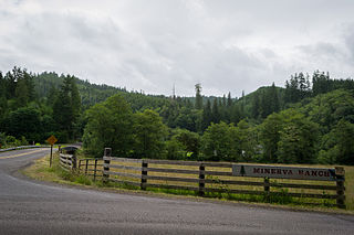
Minerva is an unincorporated community in Lane County, Oregon, United States. It is located about 13 miles (21 km) northeast of Florence near the North Fork Siuslaw River within the Siuslaw National Forest.
Goldson is an unincorporated community in Lane County, Oregon, United States on Oregon Route 36 near Bear Creek, about 3.5 miles (5.6 km) from Cheshire. Goldson post office was established in 1891 and named for the first postmaster, J. M. Goldson. It ran until 1934. The community's elevation is 404 feet (123 m).

Blooming is an unincorporated community in Washington County, Oregon, United States near the Tualatin River, about two miles south of Cornelius. Its elevation is 190 feet. There are several plant nurseries in the area.

Horton is an unincorporated community in Lane County, Oregon, United States. It is about three miles northeast of Blachly, in the Lake Creek valley of the Central Oregon Coast Range.

Birkenfeld is an unincorporated community in Columbia County, Oregon, United States, in the Nehalem Valley on Oregon Route 202 between Jewell and Mist.

Olney is an unincorporated community and former company town in Clatsop County, Oregon, United States, on Oregon Route 202 approximately eight miles south of Astoria. Its post office is assigned ZIP code 97325.

Quincy is an unincorporated community in Columbia County, Oregon, United States. It is located about 4.5 miles northeast of Clatskanie and 3.5 miles southwest of Mayger in a drained and diked area of the Columbia River lowlands.

Greenville is an unincorporated historic community in Washington County, Oregon, United States. It is located approximately two miles south of Banks on Oregon Route 47.
Harlan is an unincorporated community in Lincoln County, Oregon, United States, about 30 miles west of Corvallis. It is located in a valley of the Central Oregon Coast Range in the Siuslaw National Forest. The community's economy was once based on logging and sawmills. Cattle ranching is another mainstay of the local economy.
Necanicum is an unincorporated community in Clatsop County, Oregon, United States. It is located approximately 13 miles southeast of Seaside on U.S. Route 26 in the Northern Oregon Coast Range, next to the Necanicum River. Necanicum Junction is about a mile east of the site of the former post office, at the intersection of U.S. 26 and Oregon Route 53. It is served by the Seaside post office.
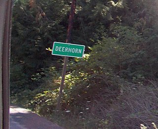
Deerhorn is an unincorporated community in Lane County, Oregon, United States. It is about 4 miles (6 km) west of Leaburg on Oregon Route 126 in the McKenzie River valley.
Gravelford is an unincorporated community in Coos County, Oregon, United States. It is about 8 miles (13 km) northeast of Myrtle Point, at the confluence of the North Fork Coquille River and the East Fork Coquille River.
Gaylord is an unincorporated community in Coos County, Oregon, United States. It is about 12 miles (19 km) south of Myrtle Point on Oregon Route 542, near the South Fork Coquille River.
Walker is an unincorporated community in Lane County, Oregon, United States. It is located about 4 miles (6 km) north of Cottage Grove on Oregon Route 99, near the Coast Fork Willamette River.
Holland is an unincorporated community in Josephine County, Oregon, United States. It is about eight miles southeast of Cave Junction, in the Illinois Valley south of Oregon Route 46.
Dora is an unincorporated community in Coos County, Oregon, United States. It is about 19 miles (31 km) east of Coquille near the East Fork Coquille River on the former route of the Coos Bay Wagon Road. It is in the Southern Oregon Coast Range.

Thatcher is an unincorporated historic community in Washington County, Oregon, United States. It was located approximately three miles north of Forest Grove at the intersection of Hillside and Thatcher roads. The area is part of the Forest Grove Rural Fire Protection District.
Peel is an unincorporated community in Douglas County, Oregon, United States. It is located about six miles southeast of Glide near the Little River.
Clifton is an unincorporated community in Clatsop County, Oregon, United States. It is located north of U.S. Route 30, about nine miles northwest of Westport on the south bank of the Columbia River. It is on Clifton Channel across from Tenasillahe Island.
Hobsonville is an unincorporated community in Tillamook County, Oregon, United States. Although it is considered a ghost town, it is still classified as a populated place by the United States Geological Survey (USGS). Hobsonville is on the east shore of Tillamook Bay, about 2 miles south of Garibaldi via U.S. Route 101 or about a mile from Garibaldi across Miami Cove.
References
- ↑ U.S. Geological Survey Geographic Names Information System: Hamlet, Oregon
- 1 2 Oregon Atlas & Gazetteer (7th ed.). Yarmouth, Maine: DeLorme. 2008. p. 20. ISBN 978-0-89933-347-2.
- 1 2 3 Friedman, Ralph (1990). In Search of Western Oregon (2nd ed.). Caldwell, Idaho: The Caxton Printers, Ltd. pp. 26, 145. ISBN 0-87004-332-3.
- 1 2 McArthur, Lewis A.; McArthur, Lewis L. (2003) [1928]. Oregon Geographic Names (7th ed.). Portland, Oregon: Oregon Historical Society Press. pp. 439–440. ISBN 978-0875952772.
- 1 2 Friedman, Ralph (1993) [1972]. Oregon for the Curious (3rd ed.). Portland, Oregon: Pars Publishing Company. p. 189. ISBN 0-87004-222-X.
- ↑ Friedman, Ralph (1978). "The Small Drama of Hamlet". Tracking Down Oregon. Caldwell, Idaho: The Caxton Printers, Ltd. pp. 35–42. ISBN 0-87004-257-2.
Municipalities and communities of Clatsop County, Oregon, United States | ||
|---|---|---|
| Cities |  | |
| CDPs | ||
| Other communities | ||
45°50′46″N123°42′02″W / 45.84611°N 123.70056°W
| | This Clatsop County, Oregon state location article is a stub. You can help Wikipedia by expanding it. |