Northport, Washington

Last updated

Northport
Northport, Washington
Stevens County Washington Incorporated and Unincorporated areas Northport Highlighted.svg
Location of Northport, Washington
Coordinates: 48°54′52″N117°46′56″W / 48.91444°N 117.78222°W / 48.91444; -117.78222
Country United States
State Washington
County Stevens
Area
[1]
  Total0.57 sq mi (1.47 km2)
  Land0.57 sq mi (1.47 km2)
  Water0.00 sq mi (0.00 km2)
Elevation
1,365 ft (416 m)
Population
 (2010) [2]
  Total295
  Estimate 
(2019) [3]
301
  Density530.86/sq mi (205.11/km2)
Time zone UTC-8 (Pacific (PST))
  Summer (DST) UTC-7 (PDT)
ZIP code
99157
Area code 509
FIPS code 53-50045
GNIS feature ID1523920 [4]
Website Town of Northport

Northport is a town in Stevens County, Washington, United States. The population was 295 at the 2010 census. [5]

Contents

History

Northport 1916 Northport 1916.jpg
Northport 1916

Northport began when railroad builder Daniel C. Corbin had agents purchase two wooded benches overlooking the Columbia River from the federal government in 1892. Corbin had plans to extend his Spokane Falls and Northern Railway (S&FN) from Little Dalles, the town seven miles south, to the rich mining districts of southern British Columbia. Northport would provide a railhead for two railroads into Canada. [6]

At this time, The Kootenai Steamship Company riverboats provided service from Little Dalles to Revelstoke, B.C. After the S&FN reached Northport on Sept. 18, 1892, the riverboats ran from Northport to Revelstoke. [7]

Northport became an international port of entry in 1895. [8]

In March 1896 a major fire occurred in the business district. At least 16 businesses were destroyed or damaged. [9] [10]

The north half of the Colville Indian Reservation, across the river from Northport, was opened to mining in February 1896. Miners and prospectors flooded into the area and came into town to record their claims, get supplies and entertain themselves. [9] [11]

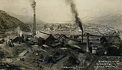
In 1890, ores rich in copper, gold and silver were discovered in Canada at Red Mountain, near the present city of Rossland, British Columbia. Mines were developed and the ore was laboriously shipped out by wagon on a rude road 17 miles and ferried across the Columbia river to Northport and the S&FN. In January 1896, 170 four horse teams hauled ore down the road in one week. [12] The need for rail transportation was great and D. C. Corbin set about obtaining approvals and charters to fill the need. Construction began on the American side in May 1896. A ferry was built at Northport to carry engines and cars across the Columbia River until a bridge could be built. The Columbia and Red Mountain railroad began service in December. The bridge over the Columbia River was begun in early spring 1897 and completed in October. Northport was now a busy railway center boasting a two-story 180 foot long passenger depot, the connection point of three railroads linking the supply center of Spokane to the mining districts of British Columbia. [13]

The Red Mountain mines were now producing more ore than the smelter at Trail British Columbia could process. The mine owners, mostly Americans, wanted another smelter. Northport had limestone and rail connections for importing coke, coal and building materials and exporting the smelter matte to distant refineries. D. C. Corbin donated the land on a bench overlooking the river north of town and construction began in August 1897. The smelter began operations in January 1898. Two hundred men were employed which soon increased to almost six hundred. [14] [15] [16]

On May 3, 1898, another major fire reduced to ashes the entire business district and the red light district, more than three city blocks. The city was quickly rebuilt. [17] [18]

On June 23, 1898, an election was held to incorporate an area of the county with 1500 inhabitants as the "City of Northport", and to elect a mayor and city council. Incorporation passed 228 for, 5 against. Now, instead of the county collecting over $5000 in local saloon fees, the new town could afford to improve the streets, build sidewalks, have a health officer, a fire department, a marshall and a jail. [19]

The US immigration inspector was located at Northport in 1900. [20]

At this time, the city was financed without property taxes but by licensing saloons, and by fines levied on gambling and courtesans. [21]

In these first years, the smelter mostly treated the copper and gold ores from the LeRoi mine near Rossland, B. C., but in 1906 the LeRoi contracted the Trail, B. C. smelter to treat its ores and the Northport smelter gradually ceased operations, shipping the last matte in May 1911. [22]

After the smelter was idled, things looked bleak for Northport. Times were hard, the population fell to 300, many businesses closed and the Northport State Bank became insolvent, unable to pay its depositors. [23] [24]

On July 22, 1914, Northport suffered another major fire. Blocks 3 and 4 were destroyed. This included most of the business district, a warehouse and the Great Northern train depot. [25] [26] Only a few businesses rebuilt and the once densely packed block 4 has remained mostly vacant ever since. [27]

Then, in September 1915, the Northport Smelting and Refining Co. was purchased by the Hercules Mining Co. and the Tamarack and Custer Consolidated Mining Co. The smelter was renovated to treat lead ores, and began operations March 12, 1916. [28] [29]

At the end of the world war, demand for lead fell and unfavorable freight rates led the Northport smelter to close in 1921. The plant was sold to the American Smelting and Refining Company (ASARCO) in August 1922. ASARCO dismantled the works and the boom days were over. [30] [29]

In 1925, in addition to the general depressed business conditions locally, the smelter at Trail, British Columbia, 20 miles up the river valley, doubled sulfur emissions. The toxic smoke drifted down the river valley to the United States. Trees died, crops withered and cattle sickened. A meeting of the local farmers led to the formation of a Citizens Protective Association and helped bring the situation to the attention of members of congress. The US State Department opened negotiations with Canada and the matter was referred to The International Joint Commission. It was the first case of air pollution to come before an international tribunal. Negotiations dragged on for years. In 1934 President Roosevelt pressed the case, leading to more studies and a Final Decision was arrived at on Mar 11, 1941 in which $438,000 was paid to compensate the farmers. Individual farmers who had made claims received an amount that was only a small fraction of their losses. [31] [32]

The Tribunal declared that "no state has the right to use or permit the use of its territory in such a manner as to cause injury by fumes in or to the territory of another or the properties or persons therein, when the case is of serious consequence". [33] The Trail Smelter case became "one of the most cited and fundamental cases for international environmental law". [34]

Northport was given its name since it was once the northernmost town on the S&FN. [35]

Geography

Northport is located at 48°54′52″N117°46′56″W / 48.91444°N 117.78222°W / 48.91444; -117.78222 (48.914460, -117.782331). [36]

According to the United States Census Bureau, the town has a total area of 0.58 square miles (1.50 km2), all of it land. [37]

Climate

This climatic region is typified by large seasonal temperature differences, with warm to hot (and often humid) summers and cold (sometimes severely cold) winters. According to the Köppen Climate Classification system, Northport has a humid continental climate, abbreviated "Dfb" on climate maps. [38]

The hottest temperature measured in Northport is 113 °F (45 °C) during the 2021 Western North America heat wave in June. [39] The coldest reading is −32 °F (−36 °C) from January 1909. [39] The coldest daily maximum in Northport were two separate −5 °F (−21 °C) measurements, in 1902 and 1968. [39] During the 1991–2020 set of normals, the average coldest maximum was relatively close to the normals at 18 °F (−8 °C). [39] Ice days are common in winter, with normals just below freezing. [39]

Warm nights are very rare. The warmest in recorded history is 73 °F (23 °C) in August 1945. [39] During a normal year, the warmest low is at a mild 62 °F (17 °C). [39]

Climate data for Northport, Washington (1991–2020 normals, extremes 1899–present)
MonthJanFebMarAprMayJunJulAugSepOctNovDecYear
Record high °F (°C)57
(14)
60
(16)
76
(24)
92
(33)
102
(39)
113
(45)
111
(44)
109
(43)
105
(41)
87
(31)
69
(21)
58
(14)
113
(45)
Mean maximum °F (°C)44.4
(6.9)
51.3
(10.7)
65.0
(18.3)
77.5
(25.3)
87.5
(30.8)
91.8
(33.2)
99.1
(37.3)
99.8
(37.7)
90.7
(32.6)
73.5
(23.1)
55.7
(13.2)
44.9
(7.2)
101.4
(38.6)
Average high °F (°C)31.1
(−0.5)
38.7
(3.7)
49.1
(9.5)
59.6
(15.3)
69.6
(20.9)
75.2
(24.0)
85.4
(29.7)
85.7
(29.8)
75.2
(24.0)
56.9
(13.8)
40.5
(4.7)
31.5
(−0.3)
58.2
(14.6)
Daily mean °F (°C)25.8
(−3.4)
30.3
(−0.9)
38.1
(3.4)
46.1
(7.8)
55.2
(12.9)
60.9
(16.1)
68.0
(20.0)
67.7
(19.8)
58.9
(14.9)
45.4
(7.4)
33.9
(1.1)
26.5
(−3.1)
46.4
(8.0)
Average low °F (°C)20.5
(−6.4)
22.0
(−5.6)
27.2
(−2.7)
32.7
(0.4)
40.8
(4.9)
46.7
(8.2)
50.7
(10.4)
49.7
(9.8)
42.6
(5.9)
33.9
(1.1)
27.3
(−2.6)
21.5
(−5.8)
34.6
(1.4)
Mean minimum °F (°C)3.6
(−15.8)
11.0
(−11.7)
18.5
(−7.5)
25.2
(−3.8)
31.3
(−0.4)
38.0
(3.3)
43.4
(6.3)
42.7
(5.9)
33.7
(0.9)
22.3
(−5.4)
14.6
(−9.7)
7.1
(−13.8)
−1.9
(−18.8)
Record low °F (°C)−32
(−36)
−27
(−33)
−11
(−24)
12
(−11)
20
(−7)
26
(−3)
30
(−1)
26
(−3)
17
(−8)
6
(−14)
−11
(−24)
−28
(−33)
−32
(−36)
Average precipitation inches (mm)2.24
(57)
1.32
(34)
1.64
(42)
1.68
(43)
2.12
(54)
2.44
(62)
1.01
(26)
0.61
(15)
0.97
(25)
1.56
(40)
2.24
(57)
2.47
(63)
20.30
(516)
Average snowfall inches (cm)15.8
(40)
5.9
(15)
1.7
(4.3)
0.1
(0.25)
0.0
(0.0)
0.0
(0.0)
0.0
(0.0)
0.0
(0.0)
0.0
(0.0)
0.2
(0.51)
5.9
(15)
17.0
(43)
46.6
(118.06)
Average extreme snow depth inches (cm)12.8
(33)
8.7
(22)
3.5
(8.9)
0.0
(0.0)
0.0
(0.0)
0.0
(0.0)
0.0
(0.0)
0.0
(0.0)
0.0
(0.0)
0.0
(0.0)
3.3
(8.4)
10.5
(27)
14.4
(37)
Average precipitation days (≥ 0.01 in)12.18.79.59.110.210.15.33.55.49.012.013.1108.0
Average snowy days (≥ 0.1 in)7.03.51.40.10.00.00.00.00.00.12.88.723.6
Source 1: NOAA [40]
Source 2: National Weather Service [39]

Demographics

Historical population
CensusPop.Note
1900 787
1910 476−39.5%
1920 90690.3%
1930 391−56.8%
1940 4279.2%
1950 48714.1%
1960 482−1.0%
1970 423−12.2%
1980 368−13.0%
1990 308−16.3%
2000 3369.1%
2010 295−12.2%
2019 (est.)301 [3] 2.0%
U.S. Decennial Census [41]
2015 Estimate [42]

2010 census

As of the census [2] of 2010, there were 295 people, 139 households, and 76 families living in the town. The population density was 508.6 inhabitants per square mile (196.4/km2). There were 168 housing units at an average density of 289.7 per square mile (111.9/km2). The racial makeup of the town was 94.2% White, 0.3% African American, 1.7% Native American, 0.7% Asian, 1.0% from other races, and 2.0% from two or more races. Hispanic or Latino of any race were 4.1% of the population.

There were 139 households, of which 24.5% had children under the age of 18 living with them, 38.1% were married couples living together, 11.5% had a female householder with no husband present, 5.0% had a male householder with no wife present, and 45.3% were non-families. 38.1% of all households were made up of individuals, and 14.4% had someone living alone who was 65 years of age or older. The average household size was 2.12 and the average family size was 2.75.

The median age in the town was 48.5 years. 21% of residents were under the age of 18; 6.5% were between the ages of 18 and 24; 18.3% were from 25 to 44; 35.9% were from 45 to 64; and 18.3% were 65 years of age or older. The gender makeup of the town was 50.2% male and 49.8% female.

2000 census

As of the census of 2000, there were 336 people, 151 households, and 83 families living in the town. The population density was 592.7 people per square mile (227.6/km2). There were 179 housing units at an average density of 315.8 per square mile (121.2/km2). The racial makeup of the town was 94.94% White, 0.60% Native American, 0.60% Asian, 0.30% Pacific Islander, 0.30% from other races, and 3.27% from two or more races. Hispanic or Latino of any race were 5.36% of the population.

There were 151 households, out of which 22.5% had children under the age of 18 living with them, 47.0% were married couples living together, 5.3% had a female householder with no husband present, and 44.4% were non-families. 36.4% of all households were made up of individuals, and 12.6% had someone living alone who was 65 years of age or older. The average household size was 2.23 and the average family size was 3.01.

In the town, the age distribution of the population shows 25.0% under the age of 18, 5.7% from 18 to 24, 22.0% from 25 to 44, 30.1% from 45 to 64, and 17.3% who were 65 years of age or older. The median age was 43 years. For every 100 females, there were 100.0 males. For every 100 females age 18 and over, there were 95.3 males.

The median income for a household in the town was $21,719, and the median income for a family was $26,875. Males had a median income of $28,929 versus $16,000 for females. The per capita income for the town was $11,679. About 15.9% of families and 27.7% of the population were below the poverty line, including 38.5% of those under age 18 and 17.4% of those age 65 or over.

Janni's chimney

Peter Janni was born in Italy in 1874 and came to America to work on the railroad. Eventually he ended up in Northport and in 1923 purchased a limestone quarry south of Northport. [43] Janni shipped limestone all over Washington from the quarry. The quarry was located in the center of the tetrahedrite mineralized zone of Northern Stevens County. [43] Ore deposits in the district occur in "Vugs" or "Chimneys" usually narrow veins of galena with high silver content. In 1953 Janni's crew discovered a chimney of galena with silver, 6 feet by 5 feet on the second level of the quarry. They followed it down and shipped nearly forty tons of high grade galena to CM&S Company's lead refinery in nearby Trail. After following it down 15 feet Janni came and said "cover the damn thing up". [43] Janni's men pleaded to follow the chimney further, but Janni refused saying "maybe someday we will dig her up again". [43] Why he abandoned the chimney remains a mystery. According to some old timers in Northport the rich chimney is still at the quarry buried under tons of limestone located on the second level. [43]

Footnotes

  1. "2019 U.S. Gazetteer Files". United States Census Bureau. Retrieved August 7, 2020.
  2. 1 2 "U.S. Census website". United States Census Bureau . Retrieved December 19, 2012.
  3. 1 2 "Population and Housing Unit Estimates". United States Census Bureau. May 24, 2020. Retrieved May 27, 2020.
  4. "US Board on Geographic Names". United States Geological Survey. October 25, 2007. Retrieved January 31, 2008.
  5. "2010 Census Redistricting Data (Public Law 94-171) Summary File". American FactFinder. United States Census Bureau . Retrieved September 17, 2012.[ dead link ]
  6. Fahey, John. Inland Empire, D. C. Corbin and Spokane, Seattle, University of Washington Press, 1965, p119
  7. Anon 1904, p. 138.
  8. Anon 1904, p. 149.
  9. 1 2 Anon 1904, p. 143.
  10. Northport Pioneers,Northport over Forty Club, Statesman-Examiner, 1981, Colville, WA, p22
  11. The Northport News, Northport,Washington, 1896-03-05, "Mining Locations"
  12. The Northport News, Northport,Washington,1896-01-23
  13. Fahey, John, Inland Empire, D. C. Corbin and Spokane, Seattle, University of Washington Press, 1965, pp161-164
  14. Fahey, John, Inland Empire, D. C. Corbin and Spokane, Seattle, University of Washington Press, 1965, pp. 175,176
  15. Anon 1904, p. 144.
  16. Reeves, p. 75.
  17. The Northport News, Northport,Washington, 1898-05-05, 1898-05-12
  18. The Spokesman-Review, Spokane, WA, 1898-05-04
  19. The Northport News, Northport,Washington, 1898-06-08
  20. Anon 1904, p. 146.
  21. The Northport News, Northport,Washington, 1901-04-17
  22. Northport Mining and Smelting Company, Manuscript Group 234, Special Collections and Archives, University of Idaho https://www.lib.uidaho.edu/special-collections/Manuscripts/dmginv/mg234.htm
  23. Reeves, p. 78.
  24. Northport over Forty Club, Northport Pioneers, Statesman-Examiner, 1981, Colville, WA, p29
  25. The Spokesman-Review, Spokane, WA, 1914-07-23
  26. Spokane Daily Chronicle, Spokane, WA, 1914-07-24
  27. Sanborn Map Co.,New York, Northport,Washington, February 1918, August 1929
  28. The Northport News, Northport,Washington, 1922-08-18 "Smelter History Here from the Beginning to Now"
  29. 1 2 Northport Mining and Smelting Company, Manuscript Group 234, Special Collections and Archives, University of Idaho
  30. Reeves, p. 79.
  31. Reeves, p. 100.
  32. The Trail Smelter Case: International Air Pollution in the Columbia Valley, Keith A. Murray, BC Studies, no. 15, Autumn 1972 https://ojs.library.ubc.ca/index.php/bcstudies/article/download/757/799
  33. Trail Smelter Arbitration, U.S.-Canada, Decision, March 11th, 1941, Reports of International Arbitral Awards, Vol. 3 1938-1982.
  34. An International Environmental Law case study: The Trail Smelter Arbitration, Catherine Prunella, International Pollution Issues, City University of New York, December 2014 https://intlpollution.commons.gc.cuny.edu/an-international-environmental-law-case-study-the-trail-smelter-arbitration/
  35. Majors, Harry M. (1975). Exploring Washington. Van Winkle Publishing Co. p. 58. ISBN   978-0-918664-00-6.
  36. "US Gazetteer files: 2010, 2000, and 1990". United States Census Bureau. February 12, 2011. Retrieved April 23, 2011.
  37. "US Gazetteer files 2010". United States Census Bureau. Archived from the original on July 2, 2012. Retrieved December 19, 2012.
  38. Climate Summary for Northport, Washington
  39. 1 2 3 4 5 6 7 8 "NOAA Online Weather Data – NWS Spokane". National Weather Service. Retrieved November 19, 2023.
  40. "U.S. Climate Normals Quick Access – Station: Northport, WA". National Oceanic and Atmospheric Administration. Retrieved November 19, 2023.
  41. United States Census Bureau. "Census of Population and Housing" . Retrieved October 4, 2013.
  42. "Population Estimates". United States Census Bureau. Archived from the original on October 19, 2016. Retrieved July 14, 2016.
  43. 1 2 3 4 5 N.L. Barlee, Gold Creeks and Ghost Towns of Northeastern Washington., Hancock House Publishers., 2004

Related Research Articles

<span class="mw-page-title-main">Stevens County, Washington</span> County in Washington, United States

Stevens County is a county located in the U.S. state of Washington along the Canada–US border. At the 2020 census, its population was 46,445. As of July 2021, the population was estimated to be 47,426. The county seat and largest city is Colville. The county was created in 1863 and named after Isaac Stevens, the first governor of Washington Territory.

<span class="mw-page-title-main">Spokane County, Washington</span> County in Washington, United States

Spokane County is a county located in the U.S. state of Washington. As of the 2020 census, its population was 539,339, making it the fourth-most populous county in Washington. The largest city and county seat is Spokane, the second largest city in the state after Seattle. The county is named after the Spokane tribe.

<span class="mw-page-title-main">Grant County, Washington</span> County in Washington, United States

Grant County is a county located in the U.S. state of Washington. As of the 2020 census, the population was 99,123. The county seat is Ephrata, and the largest city is Moses Lake. The county was formed out of Douglas County in February 1909 and is named for U.S. President Ulysses S. Grant.

<span class="mw-page-title-main">Hayden, Arizona</span> Town in Gila and Pinal Counties, Arizona

Hayden is a town in Gila and Pinal counties in Arizona, United States. According to the 2010 census, the population of the town was 662.

<span class="mw-page-title-main">Superior, Arizona</span> Town in Pinal County, Arizona

Superior is a town in Pinal County, Arizona, United States. Superior, which is in northern Pinal County, is the oldest town in that county. According to the 2020 census, the population of the town was 2,407. Superior was founded as a mining town for the Silver King and the later Magma mines; silver was mined at first, and then transitioned to copper. Currently, exploitation of the huge Resolution Copper deposit is being explored.

<span class="mw-page-title-main">Dewey–Humboldt, Arizona</span> Town in Yavapai County, Arizona

Dewey–Humboldt is a town in Yavapai County, Arizona, United States. The population of the town was 3,894 according to the 2010 census. The Dewey–Humboldt area was a census-designated place (CDP) at the 2000 census, at which time its population was 6,295.

<span class="mw-page-title-main">Kellogg, Idaho</span> City in Idaho, United States

Kellogg is a city in the Silver Valley of Shoshone County, Idaho, United States, in the Idaho Panhandle region. The city lies near the Coeur d'Alene National Forest and about 36 miles (58 km) east-southeast of Coeur d'Alene along Interstate 90. As of the 2010 United States Census, the city had a total population of 2,120, down by a third from its population in 1980.

<span class="mw-page-title-main">Wallace, Idaho</span> City in Idaho, United States

Wallace, Idaho is a city in and the county seat of Shoshone County, Idaho, in the Silver Valley mining district of the Idaho Panhandle. Founded in 1884, Wallace sits alongside the South Fork of the Coeur d'Alene River. The town's population was 784 at the 2010 census.

<span class="mw-page-title-main">Neihart, Montana</span> Town in Montana, United States

Neihart is a town in Cascade County, Montana, United States. It is located in the center of Little Belt Mountains. The population was 43 at the 2020 census. It is part of the Great Falls, Montana, Metropolitan Statistical Area.

<span class="mw-page-title-main">McGill, Nevada</span> CDP in Nevada, United States

McGill is a census-designated place (CDP) in White Pine County, Nevada, United States. The population was 1,148 at the 2010 census.

<span class="mw-page-title-main">Cornwall, Pennsylvania</span> Borough in Pennsylvania, United States

Cornwall is a borough in Lebanon County, Pennsylvania, United States. It is part of the Lebanon, PA Metropolitan Statistical Area. The population was 4,604 at the 2020 census.

<span class="mw-page-title-main">Republic, Washington</span> City in Washington, United States

Republic is a city in Ferry County, Washington, United States. The population was 1,073 at the 2010 census, a 12.5% increase over the 2000 census. It is the county seat of Ferry County. It was the largest mining camp in the Republic Mining District, and home to the "Hot Air Line" railway.

<span class="mw-page-title-main">Davenport, Washington</span> City in Washington, United States

Davenport is the county seat of and largest city in Lincoln County, Washington, United States. The population was 1,703 at the 2020 census. As the seat of government for the county and its largest population center, Davenport serves as an important hub for business, medical and educational services in Lincoln County.

<span class="mw-page-title-main">Oroville, Washington</span> City in Washington, United States

Oroville is a city located in the northern bulk of the Okanogan Highlands in north-central Washington, United States. Oroville is a member municipality of Okanogan County, Washington, situated between Omak and Penticton. The population was 1,686 at the 2010 census.

<span class="mw-page-title-main">Springdale, Washington</span> Town in Washington, United States

Springdale is a town in Stevens County, Washington, United States. The population was 285 at the 2010 census.

<span class="mw-page-title-main">Rossland, British Columbia</span> City in British Columbia, Canada

Rossland is in the West Kootenay region of south central British Columbia. High in the Monashee Mountains, the city lies immediately east of the intersections of BC highways 3B and 22. The facilities provide a winter base for the nearby multi-peak ski hills of the Red Mountain Resort. In the non-winter months Rossland is frequented by mountain bikers, with golf and fishing options nearby as well.

<i>Lytton</i> (sternwheeler) Canadian sternwheel steamboat

Lytton was a sternwheel steamboat that ran on the Arrow Lakes and the Columbia River in southeastern British Columbia and northeastern Washington from 1890 to 1904.

<span class="mw-page-title-main">Trail, British Columbia</span> City in British Columbia, Canada

Trail is a city in the West Kootenay region of the Interior of British Columbia, Canada. It was named after the Dewdney Trail, which passed through the area. The town was first called Trail Creek or Trail Creek Landing, and the name was shortened to Trail in 1897.

<span class="mw-page-title-main">Spokane metropolitan area</span> Metropolitan statistical area in Washington, United States

The Spokane–Spokane Valley Metropolitan Statistical Area, as defined by the United States Census Bureau, is an area consisting of Spokane and Stevens counties in Washington state, anchored by the city of Spokane and its largest suburb, Spokane Valley. As of July 1, 2021, the MSA had an estimated population of 593,466. The Spokane Metropolitan Area and the neighboring Coeur d'Alene metropolitan area, make up the larger Spokane–Coeur d'Alene combined statistical area. The urban areas of the two MSAs largely follow the path of Interstate 90 between Spokane and Coeur d'Alene. In 2010, the Spokane–Spokane Valley MSA had a gross metropolitan product of $20.413 billion.

The Spokane Falls & Northern (SF&N) is a historic railroad that operated in northeast Washington state. The SF&N initially connected the city of Spokane with the Canada–United States border at Waneta, British Columbia.

References