
The Kootenays or Kootenay is a region of southeastern British Columbia. It takes its name from the Kootenay River, which in turn was named for the Kutenai First Nations people.

The Kootenay River or Kootenai River is a major river of the Northwest Plateau in southeastern British Columbia, Canada, and northern Montana and Idaho in the United States. It is one of the uppermost major tributaries of the Columbia River, the largest North American river that empties into the Pacific Ocean. The Kootenay River runs 781 kilometres (485 mi) from its headwaters in the Kootenay Ranges of the Canadian Rockies, flowing from British Columbia's East Kootenay region into northwestern Montana, then west into the northernmost Idaho Panhandle and returning to British Columbia in the West Kootenay region, where it joins the Columbia at Castlegar.
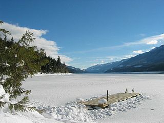
The Village of Nakusp is located south of the mouth of Kuskanax Creek, on the Upper Arrow Lake in the West Kootenay region of southeastern British Columbia. Lying between the Selkirk and Monashee ranges, the village is known for its nearby hot springs and picturesque mountain lakeside setting.
The Columbia and Kootenay Railway (C&KR) was a historic railway operated by the Canadian Pacific Railway (CPR) in the West Kootenay region of British Columbia. This 25-mile (40 km) route, beside the unnavigable Kootenay River, linked Nelson on the west arm of Kootenay Lake with Robson at the confluence of the Kootenay River and the Columbia River near Castlegar.

The Arrow Lakes in British Columbia, Canada, divided into Upper Arrow Lake and Lower Arrow Lake, are widenings of the Columbia River. The lakes are situated between the Selkirk Mountains to the east and the Monashee Mountains to the west. Beachland is fairly rare, and is interspersed with rocky headlands and steep cliffs. Mountain sides are heavily forested, and rise sharply to elevations around 2,600 metres.

The Columbia Mountains are a group of mountain ranges along the Upper Columbia River in British Columbia, Montana, Idaho and Washington. The mountain range covers 135,952 km². The range is bounded by the Rocky Mountain Trench on the east, and the Kootenai River on the south; their western boundary is the edge of the Interior Plateau. Seventy-five percent of the range is located in Canada and the remaining twenty-five percent in the United States; American geographic classifications place the Columbia Mountains as part of the Rocky Mountains complex, but this designation does not apply in Canada. Mount Sir Sandford is the highest mountain in the range, reaching 3,519 metres (11,545 ft).
Trout Lake is a ribbon lake in the West Kootenay region of southeastern British Columbia. Between the Selkirk Mountains to the west and the Purcell Mountains to the east, the lake is about 23 kilometres (14 mi) long and 1.6 kilometres (1 mi) wide. Lardeau Creek flows into the northern end and Lardeau River flows from the southern end. BC Highway 31 skirts the northeast shore. The northern end is about 90 kilometres (56 mi) by road and ferry southeast of Revelstoke.
Silverton is a village about 5 kilometres (3 mi) south of New Denver in the West Kootenay region of southeastern British Columbia. The former steamboat landing is at the mouth of Silverton Creek on the eastern shore of Slocan Lake. The locality, on BC Highway 6 at the junction of BC Highway 31A, is about 95 kilometres (59 mi) by road north of Castlegar and 155 kilometres (96 mi) by road and ferry south of Revelstoke.

The Village of Slocan is in the West Kootenay region of southeastern British Columbia. The former steamboat landing and ferry terminal is at the mouth of Springer Creek, at the foot of Slocan Lake. The locality, on BC Highway 6 is about 69 kilometres (43 mi) by road north of Castlegar and 183 kilometres (114 mi) by road and ferry south of Revelstoke.

The era of steamboats on the Arrow Lakes and adjoining reaches of the Columbia River is long-gone but was an important part of the history of the West Kootenay and Columbia Country regions of British Columbia Canada. The Arrow Lakes are formed by the Columbia River in southeastern British Columbia. Steamboats were employed on both sides of the border in the upper reaches of the Columbia, linking port towns on either side of the border, and sometimes boats would be built in one country and operated in the other. Tributaries of the Columbia include the Kootenay River which rises in Canada, then flows south into the United States, then bends north again back into Canada, where it widens into Kootenay Lake. As with the Arrow Lakes, steamboats once operated on the Kootenay River and Kootenay Lake.
Robson is an unincorporated community in the West Kootenay region of southeastern British Columbia. The former steamboat landing and railway terminal is on the northeast side of the Columbia River. The residential area is off Broadwater Road, within the northwest part of Greater Castlegar.
Columbia Country refers to the upper basin of the Columbia River in the Canadian province of British Columbia. It includes a smaller region known as the Columbia Valley, near the river's headwaters at Columbia Lake in the Rocky Mountain Trench, as well as the Big Bend of that river, now mostly inundated by Kinbasket Lake and Revelstoke Lake.
Lytton was a sternwheel steamboat that ran on the Arrow Lakes and the Columbia River in southeastern British Columbia and northeastern Washington from 1890 to 1904.

Columbia was a sternwheel steamboat that ran on the Arrow Lakes in British Columbia from 1891 to 1894. Columbia should be distinguished from the many other vessels with the same or similar names, including in particular the propeller-driven steamboat Columbia that ran on the Arrow Lakes for many years.

The Nakusp was a sternwheel steamboat that operated from 1895 to 1897 on the Arrow Lakes of British Columbia.
Raspberry is an unincorporated community in the West Kootenay region of southeastern British Columbia. On the northeast side of the Columbia River adjacent to the mouth of Norns Creek, the residential area is part of Greater Castlegar.

Marion was a small sternwheel steamboat that operated in several waterways in inland British Columbia from 1888 to 1901.
Rosebery is an unincorporated community about 6 kilometres (4 mi) north of New Denver in the West Kootenay region of southeastern British Columbia. The former steamboat landing and ferry terminal is at the mouth of Wilson Creek on the eastern shore of Slocan Lake. The locality, on BC Highway 6, is about 106 kilometres (66 mi) by road north of Castlegar and 144 kilometres (89 mi) by road and ferry south of Revelstoke.

Halcyon Hot Springs, also known simply as Halcyon, is a hot springs resort and spa on the east side of Upper Arrow Lake, between Galena Bay and Nakusp, in the West Kootenay region of British Columbia. Nearby to the northeast, Halcyon Mountain derives its name from the springs.

Mount Burnham is a 2,869-metre (9,413-foot) mountain summit located in British Columbia, Canada.
