Suncrest, Washington | |
---|---|
Coordinates: 47°48′53″N117°34′36″W / 47.81472°N 117.57667°W Coordinates: 47°48′53″N117°34′36″W / 47.81472°N 117.57667°W | |
Country | United States |
State | Washington |
County | Stevens |
Area | |
• Total | 9.86 sq mi (25.5 km2) |
Elevation | 1,840 ft (560 m) |
Population | |
• Total | 5,413 |
Time zone | UTC-8 (Pacific (PST)) |
• Summer (DST) | UTC-7 (PDT) |
ZIP code | 99026 |
Area code | 509 |
GNIS feature ID | 2807191 [2] |
Suncrest is a census-designated place (CDP) in Stevens County, Washington, United States. Though it is not incorporated as a city or town, the CDP's population of 5,413 [1] at the 2020 census makes Suncrest the largest community in the county. [3] The community is located along the Spokane River 9.7 miles northwest of the city of Spokane, of which it is a exurb and bedroom community. The community experienced substantial growth starting in the mid-1980s, with gated community and suburban style development. State Route 291 is the main thoroughfare through Suncrest, as well as its main connection to the surrounding area including Spokane. [4]
The Spokane people inhabited the area for thousands of years prior to European settlement. [5] The river supported salmon runs that provided bountiful food for the area's inhabitants, though the runs were killed off when Long Lake Dam was built in 1915 without a fish ladder. [6]
White settlers have had a permanent presence in the area since the early 1800s. In 1810, the North West Company established Spokane House at the confluence of the Spokane and Little Spokane River, [7] just over a mile upstream from present day Suncrest. [8] It was the first permanent white settlement in what would become the state of Washington. [7]
Contemporary Suncrest came to be in the mid-1960s when development began on the residential community in the area. [9] Development boomed starting in the 1980s, with more than 1,000 homes constructed over the ten years leading up to 1996. By that time, Suncrest's population had surpassed 5,000 residents, making the community larger than Colville, the county seat. This rapid growth put a strain on both Suncrest and nearby Spokane's transportation infrastructure, namely SR-291. With limited services and employment opportunities, residents of Suncrest had little choice but to commute into Spokane for work and much of their shopping needs. Suncrest's location in Stevens County and dependence on Spokane County complicated attempts to improve the situation. “Their lifestyle in Suncrest is subsidized by the residents of Spokane," Spokane Planing Director Charlie Dotson told The Spokesman-Review in 1996. By that time, the Suncrest community had become effectively a bedroom community of Spokane. [4] Development continued into the 2000s, with increased focus on non-residential development to serve the community, including retail and commercial businesses, as well as a $1 million dollar medical facility project in 2007. [10]
Suncrest is located in the extreme southeast corner of Stevens County. The Spokane River to the immediate south of Suncrest marks the border between Stevens and Spokane Counties to the south, and the county line between the two runs north–south less than a mile to the east of Suncrest. The closest community is [[Nine Mile Falls, Washington|Nine Mile Falls, approximately 2.5 miles as the crow flies and 4.5 miles by road along State Route 291 to the southeast. The Spokane city limits are approximately 9.7 miles by road southeast of Suncrest along SR-291. [8]
The Spokane River, known as Long Lake in this area as it is a reservoir impounded by Long Lake Dam, flows in a northwesterly direction past Suncrest along the community's southeast. An area of relatively flat tableland approximately 3.5 miles long and 1 mile wide stretching from Sandy Canyon in the south to Little Sandy Canyon in the north contains the bulk of the developed area of Suncrest. The flat is an approximate elevation of 1800 feet, but falls nearly 300 feet down a steep bluff to the river on one side and is flanked by rugged terrain that rises hundreds of feet in elevation on the other side. The peak of Lookout Mountain, just two miles to Suncrest's east, is at an elevation above 3,100 feet. SR-291 runs along the edge of the flat opposite the river, and as a result almost all of the community lies between SR-291 and the river, though most of the retail areas are located on the other side of SR-291. [8]
Houses are located along the northern shore of Long Lake, [11] 9.7 miles northwest of Spokane and about 5 miles northwest of central Nine Mile Falls, the next nearest population center. The main road through Suncrest is State Highway 291.
As of the 2020 Census, the Suncrest CDP had a population of 5,413 residents across 1,922 households. [1] Estimates by the Census Bureau as of July 1, 2021 show that 94.6% of the population is white alone, 0.0% Black alone, 1.2% American Indian or Alaska Native alone, 1.0% Asian alone, 0.0% Native Hawaiian or Pacific Islander alone, 3.2% two more more races and 6.2% Hispanic or Latino. [1]
Suncrest is served by the Nine Mile Falls School District, with three public schools located in the community:
The Stevens County Fire District has also centered a fire/EMS station in the community. [12] This is the location of the district's quarterly blood drives. [13] [14]
The Stevens County Rural Library District has been a part of Suncrest since 1996[ citation needed ]. The Lakeside branch, located in Suncrest, is one of the District's larger branches[ citation needed ]. Services of SCRLD include books, movies, CDs and tapes, free Internet access, printing and copying, etc. As such, the library provides a vital resource for a wide range of users, including farmers, loggers, homeschool parents and distance education students, who view the library as "their community hub, their reference source, their connection to the Internet, their bus stop, their office, their living room even." [15]
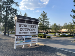
Suncrest is a commercial center for nearby rural residents. The community includes the Suncrest Shopping Center, Suncrest Outpost and a medical and dental center. [10] Growth has been very rapid during the years of 2009-2010, with over 20 new businesses opened in the community during that period. [16] Rosauers Supermarkets opened a grocery store in the community in December 2014. [17]
This area is popular with equestrians, with many back trails for horses and bicycles. In addition, the proximity of the community to Lake Spokane also called Long Lake, makes it a popular for various types of water sports, including boating and fishing. [18] Some planned developments in the area offer residents free membership in one of the community's private recreational clubs. [19]
Stevens County is a county located in the U.S. state of Washington along the Canada–US border. At the 2020 census, its population was 46,445. As of July 2021, the population was estimated to be 47,426. The county seat and largest city is Colville. The county was created in 1863 and named after Isaac Stevens, the first governor of Washington Territory.
Spokane County is a county located in the U.S. state of Washington. As of the 2020 census, its population was 539,339, making it the fourth-most populous county in Washington. The largest city and county seat is Spokane, the second largest city in the state after Seattle. The county is named after the Spokane tribe.
Evans is a census-designated place (CDP) in Columbia County, Georgia, United States. It is a suburb of Augusta and is part of the Augusta metropolitan area. The population was 29,011 at the 2010 census, up from 17,727 at the 2000 census.
Coeur d'Alene is a city and the county seat of Kootenai County, Idaho, United States. It is the largest city in North Idaho and the principal city of the Coeur d'Alene Metropolitan Statistical Area. At the 2020 census the city's population was 54,628. Coeur d'Alene is a satellite city of Spokane, which is located about thirty miles (50 km) to the west in the state of Washington. The two cities are the key components of the Spokane–Coeur d'Alene Combined Statistical Area, of which Coeur d'Alene is the third-largest city. The city is situated on the north shore of the 25-mile (40 km) long Lake Coeur d'Alene and to the west of the Coeur d'Alene Mountains. Locally, Coeur d'Alene is known as the "Lake City," or simply called by its initials, "CDA."
Metaline Falls is a town in Pend Oreille County, Washington, United States. The population was 272 at the 2020 census.
Liberty Lake is a city in Spokane County, Washington, United States located adjacent to the eponymous lake. Located just over a mile west of the Washington–Idaho border, Liberty Lake is both a suburb of Spokane, Washington and a bedroom community to Coeur d'Alene, Idaho. The population was 12,003 at the 2020 census.
Spokane is the largest city and county seat of Spokane County, Washington, United States. It is in eastern Washington, along the Spokane River, adjacent to the Selkirk Mountains, and west of the Rocky Mountain foothills, 92 miles (148 km) south of the Canadian border, 18 miles (30 km) west of the Washington–Idaho border, and 279 miles (449 km) east of Seattle, along I-90.
Town and Country is a census-designated place (CDP) in Spokane County, Washington, United States. The population was 5,068 at the 2020 census.
Spokane Valley is a city in Spokane County, Washington, United States, and the largest suburb of Spokane. It is located east of Spokane, west of Coeur d'Alene, Idaho, and surrounds the city of Millwood on three sides. The city incorporated as the City of Spokane Valley on March 31, 2003. The population was 102,976 at the 2020 census, making it the eighth-largest city in Washington state. Spokane Valley is named after the valley of the Spokane River, in which it is located. The city and the general area is colloquially referred to as "The Valley" by residents of the Spokane–Coeur d'Alene area.
Jackpot is an unincorporated community and census-designated place (CDP) in Elko County, Nevada, United States. The population was 855 as of the 2020 census. Located less than one mile (1.6 km) from the Idaho border on US 93, Jackpot has been a popular casino gaming destination for residents of Idaho and other neighboring states since its founding.
The Idaho Panhandle—locally known as North Idaho—is a salient region of the U.S. state of Idaho encompassing the state's 10 northernmost counties: Benewah, Bonner, Boundary, Clearwater, Idaho, Kootenai, Latah, Lewis, Nez Perce, and Shoshone. The Panhandle is bordered by the state of Washington to the west, Montana to the east, and the Canadian province of British Columbia to the north. The Idaho panhandle, along with Eastern Washington, comprises the region known as the Inland Northwest, headed by its largest city, Spokane, Washington.
Nine Mile Falls School District No. 325/179 is a public school district in the counties of Spokane and Stevens, Washington, USA and serves the communities of Nine Mile Falls and Suncrest.
Nine Mile Falls is an unincorporated community in Spokane County, Washington and Stevens County, Washington, United States. The community straddles the Spokane River 9 miles (14 km) away from downtown Spokane, at the location of a former falls that has been the site of Nine Mile Dam since 1908. Following the river, the community is located 16 miles (26 km) downstream from downtown.
State Route 231 (SR 231) is a 74.97-mile (120.65 km) long state highway in the U.S. state of Washington serving communities in Lincoln and Stevens counties. The highway, located entirely west of Spokane in the Inland Empire, serves Sprague, Edwall, Reardan, Springdale and Chewelah. The route extends from SR 23 north of Sprague to a concurrency with U.S. Route 2 (US 2) near Reardan and an intersection with US 395 south of Chewelah.
U.S. Route 395 (US 395) is a United States Numbered Highway that runs from California to the inland regions of Oregon and Washington. It travels north–south through Washington, including long concurrencies with Interstate 82 (I-82) and I-90, and connects the Tri-Cities region to Spokane and the Canadian border at Laurier.
State Highway 41 (SH-41) is a state highway mostly in the U.S. state of Idaho. It runs from Interstate 90 in Post Falls to U.S. Route 2 on the Washington state line. The northernmost 0.41 miles (0.66 km) of SH-41 run along State Street along the state line, with the southbound lane in the town of Newport, Washington, and the northbound lane in Oldtown, Idaho. The part of the highway in Washington is designated State Route 41 (SR 41).
State Route 291 is a 33.09-mile (53.25 km) long state highway located in Spokane and Stevens counties in the U.S. state of Washington. The highway begins at an intersection with concurrent highways U.S. Route 2 (US 2) and US 395 and travels northwest to an intersection with SR 231. It connects the north side of Spokane with a string of communities along the north bank of the Spokane River including Nine Mile Falls, Suncrest and Tumtum.
State Route 292 (SR 292) is a state highway located entirely in Stevens County, Washington, United States. The east–west highway connects SR 231 in Springdale to U.S. Route 395 (US 395) at Loon Lake. It is approximately 6 miles (9.7 km) long and follows Sheep Creek and a railroad.
The Spokane–Spokane Valley Metropolitan Statistical Area, as defined by the United States Census Bureau, is an area consisting of Spokane and Stevens counties in Washington state, anchored by the city of Spokane and its largest suburb, Spokane Valley. As of July 1, 2021, the MSA had an estimated population of 593,466. The Spokane Metropolitan Area and the neighboring Coeur d'Alene metropolitan area, make up the larger Spokane–Coeur d'Alene combined statistical area. The urban areas of the two MSAs largely follow the path of Interstate 90 between Spokane and Coeur d'Alene. In 2010, the Spokane–Spokane Valley MSA had a gross metropolitan product of $20.413 billion.
Balboa/South Indian Trail is a neighborhood in Spokane, Washington located on the northwestern side of the city. The neighborhood is largely composed of single-family residential areas that were developed after being annexed into the city in the 1950s. The neighborhood is situated on tableland above a steep bluff rising from the Spokane River to the west, that then rises up a more developed bluff towards Five Mile Prairie which is located above the neighborhood to the north and east.