Hazard, Washington

Last updated

Hazard
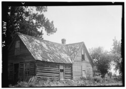
Hazard Post Office, Wild Rose Prairie, Deer Park, Spokane County, WA HABS WASH,32-DERP.V,1-2.tif
Hazard Post Office
USA Washington location map.svg
Red pog.svg
Hazard
Location within the state of Washington
Coordinates: 47°52′40″N117°31′08″W / 47.87778°N 117.51889°W / 47.87778; -117.51889
Country United States
State Washington
County Spokane
Elevation
2,145 ft (654 m)
Time zone UTC-8 (Pacific (PST))
  Summer (DST) UTC-7 (PDT)
ZIP codes
99006
GNIS feature ID1514873 [1]

Hazard is an unincorporated community in Spokane County, in the U.S. state of Washington. [2]

Contents

Geography

Hazard is located on the Wild Rose Prairie, a region of farmland in northern Spokane County between U.S. Route 395 and the Stevens County. The county line is about one mile west of Hazard. [3] There is no defined community center at Hazard, the location is dominated by farms with structures and homes spread out hundreds of feet apart. [4]

Hazard is about 12 miles by road northeast of the suburban and commercial fringes of the Spokane urban area. [3]

History

A post office called Hazard was established in 1885, and remained in operation until 1904. [5] The community was named after R. R. Hazard, a local merchant. [6]

Related Research Articles

<span class="mw-page-title-main">Benewah County, Idaho</span> County in Idaho, United States

Benewah County is a county located in the northwest part of the U.S. state of Idaho. As of the 2020 United States Census the county had a population of 9,530. The county seat and largest city is St. Maries, which has some area inside the Coeur d'Alene Reservation.

<span class="mw-page-title-main">Curtis Township, Michigan</span> Civil township in Michigan, United States

Curtis Township is a civil township of Alcona County in the U.S. state of Michigan. The population was 1,087 at the 2020 census.

<span class="mw-page-title-main">Munising Township, Michigan</span> Civil township in Michigan, United States

Munising Township is a civil township of Alger County in the U.S. state of Michigan. As of 2020, its population was 2,865.

<span class="mw-page-title-main">Allouez Township, Michigan</span> Civil township in Michigan, United States

Allouez Township is a civil township of Keweenaw County in the U.S. state of Michigan. The population was 1,428 at the 2020 census.

<span class="mw-page-title-main">Chesterfield Township, Michigan</span> Charter township in Michigan, United States

Chesterfield Charter Township is a charter township of Macomb County in the U.S. state of Michigan. As of the 2020 census the population was 45,376.

Milan is an unincorporated community in Spokane County, Washington, United States. It is named after the Italian city of Milan.

<span class="mw-page-title-main">Steptoe, Washington</span> Census-designated place in Whitman County, Washington, United States

Steptoe is a small unincorporated rural town in Whitman County, Washington, United States. The ZIP Code for Steptoe is 99111.

<span class="mw-page-title-main">Elk, Washington</span> Unincorporated community in Washington, United States

Elk is an unincorporated rural community in northern Spokane County, Washington, United States. The community is located along the Little Spokane River in the foothills of the Selkirk Mountains. A post office was established in the community in 1892.

<span class="mw-page-title-main">Eureka, Michigan</span> Census-designated place & unincorporated community in Michigan, United States

Eureka is an unincorporated community and census-designated place (CDP) in Clinton County in the U.S. state of Michigan. The population of the CDP was 233 at the 2020 census. The community is located within Greenbush Township.

<span class="mw-page-title-main">Naubinway, Michigan</span> Census-designated place & unincorporated community in Michigan, United States

Naubinway is an unincorporated community and census-designated place (CDP) in Mackinac County in the U.S. state of Michigan. The population of the CDP was 147 at the 2020 census, which was the first year that it was recorded by the census. The community is located within Garfield Township.

<span class="mw-page-title-main">Epoufette, Michigan</span> Unincorporated community in Michigan, United States

Epoufette is an unincorporated community in Mackinac County in the U.S. state of Michigan. The community is located along the northern shores of Lake Michigan along U.S. Route 2 within Hendricks Township. As an unincorporated community, Epoufette has no legally defined boundaries or population statistics of its own.

<span class="mw-page-title-main">Lake, Clare County, Michigan</span> Unincorporated community in Michigan, United States

Lake is an unincorporated community in Clare County in the U.S. state of Michigan. The community is located within Garfield Township. As an unincorporated community, Lake has no legal autonomy of its own but does have its own post office with the 48632 ZIP Code.

<span class="mw-page-title-main">Washington Township, Macomb County, Michigan</span> Charter township in Michigan, United States

Washington Charter Township, located within Metro Detroit, is a charter township of Macomb County in the U.S. state of Michigan. The population was 28,165 at the 2020 census, up from 25,139 in 2010.

<span class="mw-page-title-main">Marshall, Washington</span> Unincorporated community in Washington, United States

Marshall is an unincorporated community in Spokane County, Washington, United States. Named in 1880 for early settler William H. Marshall, Marshall has a post office with ZIP code 99020.

<span class="mw-page-title-main">Mica, Washington</span> Unincorporated community in Washington, United States

Mica is an unincorporated community in Spokane County, Washington, United States. Mica is located along State Route 27 12 miles (19 km) southeast of downtown Spokane. Mica had a post office with ZIP code 99023.

<span class="mw-page-title-main">Valleyford, Washington</span> Unincorporated community in Washington, United States

Valleyford is an unincorporated community in Spokane County, Washington, United States. Valleyford has a post office with ZIP code 99036. Valleyford was listed to have a population of 2,913 according to the 2010 United States census.

<span class="mw-page-title-main">Buckeye, Washington</span> Unincorporated community in Washington, United States

Buckeye is an unincorporated community in Spokane County, in the U.S. state of Washington. It is located along the Little Spokane River in the northern portion of the county.

<span class="mw-page-title-main">Denison, Washington</span> Unincorporated community in Washington, United States

Denison is an unincorporated community in Spokane County, in the U.S. state of Washington. The community is located on U.S. Route 395 19 miles due north of Downtown Spokane and about seven miles beyond that city's northern suburban developments. Denison lends its name to two roads in the area, Denison Road and Denison-Chattaroy Road, both of which intersect with Route 395 in the immediate vicinity of Denison. The city of Deer Park is four miles to the north.

<span class="mw-page-title-main">Peone, Washington</span> Unincorporated community in Washington, United States

Peone is an unincorporated community in Spokane County, in the U.S. state of Washington.

Rodna is an extinct town in Spokane County, in the U.S. state of Washington. The GNIS classifies it as a populated place.

References

  1. U.S. Geological Survey Geographic Names Information System: Hazard, Washington
  2. U.S. Geological Survey Geographic Names Information System: Hazard, Washington
  3. 1 2 "Washington Clayton Quadrangle". usgs.gov. U.S. Department of the Interior Geological Survey. 1944. Retrieved August 18, 2022.
  4. "Google Maps". maps.google.com. Google. Retrieved August 18, 2022.
  5. "Post Offices". Jim Forte Postal History. Retrieved August 13, 2016.
  6. Meany, Edmond S. (1923). Origin of Washington geographic names. Seattle: University of Washington Press. p. 111.