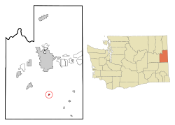
Spangle, Washington | |
---|---|
Coordinates: 47°25′50″N117°22′37″W / 47.43056°N 117.37694°W Coordinates: 47°25′50″N117°22′37″W / 47.43056°N 117.37694°W | |
Country | United States |
State | Washington |
County | Spokane |
Area | |
• Total | 0.35 sq mi (0.91 km2) |
• Land | 0.35 sq mi (0.91 km2) |
• Water | 0.00 sq mi (0.00 km2) |
Elevation | 2,444 ft (745 m) |
Population | |
• Total | 278 |
• Estimate (2019) [3] | 319 |
• Density | 914.04/sq mi (352.41/km2) |
Time zone | UTC-8 (Pacific (PST)) |
• Summer (DST) | UTC-7 (PDT) |
ZIP code | 99031 |
Area code | 509 |
FIPS code | 53-66290 |
GNIS feature ID | 1512681 [4] |
Spangle is a city [5] [6] in Spokane County, Washington, United States. The population was 278 at the 2010 census. The name comes from William Spangle, an early pioneer.
Spangle was first settled in 1872 by William Spangle. Later that same year, Spangle’s two children planted a tree, marking the settlement of their new community. They affectionally named the tree “Branchy.” To this day Branchy stands tall in the center of town. The townsite was platted in 1879. [7] It was incorporated in 1888. [6]
Spangle is located at 47°25′50″N117°22′37″W / 47.43056°N 117.37694°W (47.430641, -117.377083). [5]
According to the United States Census Bureau, the city has a total area of 0.36 square miles (0.93 km2), all of it land. [8]
Spangle is 18 miles south of Downtown Spokane along US Route 195, an important north–south highway. The highway used to run through town, however a re-alignment of 195 by-passed it and several other small towns. The old highway is still open between Spangle and Rosalia, 14 miles (23 km) to the south, offering an alternate route. The city is surrounded by the rolling farmland of the Palouse.
Historical population | |||
---|---|---|---|
Census | Pop. | %± | |
1880 | 36 | — | |
1890 | 303 | 741.7% | |
1900 | 331 | 9.2% | |
1910 | 299 | −9.7% | |
1920 | 291 | −2.7% | |
1930 | 218 | −25.1% | |
1940 | 203 | −6.9% | |
1950 | 242 | 19.2% | |
1960 | 208 | −14.0% | |
1970 | 179 | −13.9% | |
1980 | 276 | 54.2% | |
1990 | 229 | −17.0% | |
2000 | 240 | 4.8% | |
2010 | 278 | 15.8% | |
2019 (est.) | 319 | [3] | 14.7% |
U.S. Decennial Census [9] 2015 Estimate [10] |
As of the census [2] of 2010, there were 278 people, 118 households, and 74 families living in the city. The population density was 772.2 inhabitants per square mile (298.1/km2). There were 126 housing units at an average density of 350.0 per square mile (135.1/km2). The racial makeup of the city was 97.5% White, 1.4% Native American, 0.4% Asian, 0.4% from other races, and 0.4% from two or more races. Hispanic or Latino of any race were 0.4% of the population.
There were 118 households, of which 30.5% had children under the age of 18 living with them, 49.2% were married couples living together, 5.1% had a female householder with no husband present, 8.5% had a male householder with no wife present, and 37.3% were non-families. 30.5% of all households were made up of individuals, and 12.7% had someone living alone who was 65 years of age or older. The average household size was 2.36 and the average family size was 2.97.
The median age in the city was 40.8 years. 21.9% of residents were under the age of 18; 9.4% were between the ages of 18 and 24; 24.2% were from 25 to 44; 24.8% were from 45 to 64; and 19.8% were 65 years of age or older. The gender makeup of the city was 51.1% male and 48.9% female.
As of the census of 2000, there were 240 people, 99 households, and 66 families living in the town. The population density was 625.6 people per square mile (243.9/km2). There were 113 housing units at an average density of 294.6 per square mile (114.8/km2). The racial makeup of the town was 98.33% White, 0.42% Native American, and 1.25% from two or more races. Hispanic or Latino of any race were 2.50% of the population.
There were 99 households, out of which 31.3% had children under the age of 18 living with them, 50.5% were married couples living together, 11.1% had a female householder with no husband present, and 33.3% were non-families. 27.3% of all households were made up of individuals, and 11.1% had someone living alone who was 65 years of age or older. The average household size was 2.42 and the average family size was 2.94.
In the town the age distribution of the population shows 25.4% under the age of 18, 8.8% from 18 to 24, 26.7% from 25 to 44, 24.2% from 45 to 64, and 15.0% who were 65 years of age or older. The median age was 35 years. For every 100 females, there were 112.4 males. For every 100 females age 18 and over, there were 110.6 males.
The median income for a household in the town was $38,393, and the median income for a family was $40,556. Males had a median income of $31,071 versus $26,250 for females. The per capita income for the town was $17,128. About 10.3% of families and 18.8% of the population were below the poverty line, including 28.3% of those under the age of eighteen and none of those 65 or over.
Spangle is also notable as the home of Upper Columbia Academy and Liberty High School. Upper Columbia Academy, a boarding high school affiliated with the Seventh-day Adventist Church, is approximately 2 miles southeast of Spangle. 5.5 miles East of Upper Columbia Academy is Liberty High School, a rural school serving the communities of Spangle, Plaza, Fairfield, Mount Hope, Latah, and Waverly. It is a "B" school that has a total of around 450 students (K-12). [11]
Waggoner is a village in Montgomery County, Illinois, United States. The population was 245 at the 2000 census.
North Liberty is a town in Liberty Township, St. Joseph County, in the U.S. state of Indiana. The population was 1,896 at the 2010 Census. North Liberty is part of the South Bend–Mishawaka, IN-MI, Metropolitan Statistical Area.
Liberty is a town in Center Township, Union County, Indiana, United States of America. The population was 2,133 at the 2010 census. It is the county seat of Union County.
Mount Auburn is a town in Jackson Township, Wayne County, in the U.S. state of Indiana. The population was 117 at the 2010 census. The town is sandwiched between Dublin and Cambridge City.
Gulf Park Estates is an unincorporated community and census-designated place (CDP) located south of Ocean Springs in Jackson County, Mississippi, United States. It is part of the Pascagoula Metropolitan Statistical Area. The population was 5,719 at the 2010 census, up from 4,272 at the 2000 census.
Barnett is a city in Morgan County, Missouri, United States. The population was 203 at the 2010 census.
Liberty is a village in Gage County, Nebraska, United States. The population was 76 at the 2010 census.
Bethel is a town in Pitt County, North Carolina, United States. The population was 1,577 at the 2010 Census. The town is a part of the Greenville Metropolitan Area located in North Carolina's Inner Banks region. Confusingly, there are three other towns in the state named "Bethel." One is between Edenton and Hertford in the "Finger Counties" region in the northeastern corner of the state, another is in the north-central part, in Caswell County and the third is located in the Mountain Region of North Carolina, in Haywood County. There is also a community named Bethel located in Watauga County.
Locustdale is a census-designated place (CDP) in Columbia and Schuylkill counties, Pennsylvania, United States. The population was 177 at the 2010 census. It is part of the Bloomsburg–Berwick Micropolitan Statistical Area.
Isabel is a town in Dewey County, South Dakota, United States. The population was 145 at the 2020 census.
Liberty Lake is a city in Spokane County, Washington, United States located adjacent to the eponymous lake. Located just over a mile west of the Washington–Idaho border, Liberty Lake is both a suburb of Spokane, Washington and a bedroom community to Coeur d'Alene, Idaho. The population was 12,003 at the 2020 census.
Farmington is a town in Whitman County, Washington, United States. The population was 146 at the 2010 census.
Oakesdale is a town in Whitman County, Washington, United States. The population was 422 at the 2010 census.
Pax is a town in Fayette County, West Virginia, United States. The current mayor of Pax is William F. Hughes. The population was 167 at the 2010 census.
Anmoore is a town in Harrison County, West Virginia, United States. It is located at the intersection of WV 58 and Interstate 79. The population was 770 at the 2010 census.
Fairview is a town in Marion County, West Virginia, United States. The population was 408 at the 2010 census.
Granville is a town in Monongalia County, West Virginia, United States. The population was 781 at the 2010 census. It is included in the Morgantown, West Virginia Metropolitan Statistical Area.
Durbin is a town in Pocahontas County, West Virginia, United States. The population was 293 at the 2010 census.
There are three other towns called 'Liberty' in Wisconsin. See Liberty, Wisconsin
Liberty is a town in Vernon County, Wisconsin, United States. The population was 167 at the 2000 census. The unincorporated communities of Liberty and Ross are located in the town.