Elk | |
---|---|
Coordinates: 48°00′59″N117°16′32″W / 48.01639°N 117.27556°W | |
Country | United States |
State | Washington |
County | Spokane |
Elevation | 1,840 ft (560 m) |
Time zone | UTC-8 (Pacific (PST)) |
• Summer (DST) | UTC-7 (PDT) |
ZIP codes | 99009 |
GNIS feature ID | 1519263 [1] |
Elk is an unincorporated rural community in northern Spokane County, Washington, United States. [2]
Elk is located on the upper reaches of the Little Spokane River. The surrounding area consists of forests and farmland with the foothills of the Selkirk Mountains rising a few miles from town in almost all directions. The town is located 3.5 miles east of U.S. Route 2, a major highway and thoroughfare in the region connecting the Elk area to larger nearby cities with more services like Newport, Washington to the north and Spokane, Washington to the south. Elk is located roughly two miles south of the Spokane-Pend Oreille county line.
The community was originally named Peddit's Township of Elk.
[3] A post office in Elk has been in operation since 1892. [4] The current post office sits on the site of the Elk Hotel, which was destroyed by fire in the early 1970s. A one room schoolhouse was built in 1902. [5] The town is now served by the Riverside School District, which covers most of rural northern Spokane County.
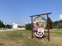
During the summer Elk holds Elk Days, when it celebrates Fathers' Day and the community's history. The community gathers, usually at Elk Park, to celebrate with various vendors and festivities often including a car show and parade.
In August 2023, the community was placed under evacuation orders due to the Oregon Road Fire which burned more than 10,000 acres near Elk, destroyed 126 residences and led to one fatality. The fire was determined to be human-caused. [6]
Riley is an unincorporated community in Harney County, Oregon, United States, located at the crossroads of U.S. Highway 395 and U.S. Highway 20, milepost 104, about 28 miles (45 km) west of Burns, the seat of Harney County. The elevation of Riley is 4,226 feet (1,288 m). The town presently consists entirely of two service establishments with attached apartments: a post office, and a general store with gas pump and garage service. It exists to serve the rural farming and ranching community that surrounds it, and highway travelers.
Elk is an unincorporated community in Mendocino County, California.
Milan is an unincorporated community in Spokane County, Washington, United States. It is named after the Italian city of Milan.
Steptoe is a small unincorporated rural town in Whitman County, Washington, United States. The ZIP Code for Steptoe is 99111.
Silver Lake is an unincorporated community and census-designated place in western Lake County, Oregon, United States, along Oregon Route 31. As of the 2010 census, it had a population of 149. Facilities include a gas station and a small store, a post office, and a public school, North Lake School, serving grades K-12.
Suncrest is a census-designated place (CDP) in Stevens County, Washington, United States. Though it is not incorporated as a city or town, the CDP's population of 5,413 at the 2020 census makes Suncrest the largest community in the county. The community is located along the Spokane River 9.7 miles northwest of the city of Spokane, of which it is a exurb and bedroom community. The community experienced substantial growth starting in the mid-1980s, with gated community and suburban style development. State Route 291 is the main thoroughfare through Suncrest, as well as its main connection to the surrounding area including Spokane.
Murray is an unincorporated community in Shoshone County, Idaho, United States. It is twenty miles from Wallace along Dobson Pass Road. Prichard Creek flows through the community, forming a thin and deep valley in the surrounding Coeur d'Alene Mountains.
Chula is a mostly rural unincorporated community in the northeastern part of Amelia County just west of the Appomattox River in the U.S. state of Virginia. The town is centered around the T-intersection of SR 636 and SR 740 in Giles District. Chula is just west of SR 604, which includes a short bypass segment built around the town in the late 20th century. The area is served by the post office 7 miles southwest at Amelia Court House, ZIP code 23002. The nearest fire station to Chula is Amelia County Volunteer Fire Department Station 4, near Mattoax, 3 miles north.
Lodore is a rural unincorporated community in northern Amelia County just south of the Appomattox River in the U.S. state of Virginia. It is located along SR 616 at its intersection with the northern terminus of SR 636.
Valley is a census-designated place and unincorporated community in Stevens County, Washington, United States. In the 2010 census the population was 146.
Marshall is an unincorporated community in Spokane County, Washington, United States. Named in 1880 for early settler William H. Marshall, Marshall has a post office with ZIP code 99020.
Mica is an unincorporated community in Spokane County, Washington, United States. Mica is located along State Route 27 12 miles (19 km) southeast of downtown Spokane. Mica had a post office with ZIP code 99023.
Valleyford is an unincorporated community in Spokane County, Washington, United States. Valleyford has a post office with ZIP code 99036. Valleyford was listed to have a population of 2,913 according to the 2010 United States census.
Thatcher is an unincorporated historic community in Washington County, Oregon, United States. It was located approximately three miles north of Forest Grove at the intersection of Hillside and Thatcher roads. The area is part of the Forest Grove Rural Fire Protection District.
Buckeye is an unincorporated community in Spokane County, in the U.S. state of Washington.
Denison is an unincorporated community in Spokane County, in the U.S. state of Washington. The community is located on U.S. Route 395 19 miles due north of Downtown Spokane and about seven miles beyond that city's northern suburban developments. Denison lends its name to two roads in the area, Denison Road and Denison-Chattaroy Road, both of which intersect with Route 395 in the immediate vicinity of Denison. The city of Deer Park is four miles to the north.
Hazard is an unincorporated community in Spokane County, in the U.S. state of Washington.
Peone is an unincorporated community in Spokane County, in the U.S. state of Washington.
Rodna is an extinct town in Spokane County, in the U.S. state of Washington. The GNIS classifies it as a populated place.
Freeman is an unincorporated community in Spokane County, Washington, United States. It is notable as being the location of the public elementary, middle and high schools serving a large area of rural southeast Spokane County.