
Spokane County is a county located in the U.S. state of Washington. As of the 2020 census, its population was 539,339, making it the fourth-most populous county in Washington. The largest city and county seat is Spokane, the second largest city in the state after Seattle. The county is named after the Spokane people.

Airway Heights is a city in Spokane County, Washington, United States, just west of Spokane. It is part of the Spokane metropolitan area and had a population of 10,757 at the 2020 census. The city's name was taken from its close proximity to the runways at Fairchild Air Force Base and Spokane International Airport.

Cheney is a city in Spokane County, Washington, United States. The full-time resident population was 13,255 as of the 2020 census. Eastern Washington University is located in Cheney. When classes are in session at EWU, the city's population reaches approximately 17,600 people temporarily.
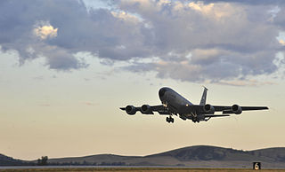
Fairchild Air Force Base (AFB) is a United States Air Force base, located in the northwest United States in eastern Washington, approximately twelve miles (20 km) southwest of Spokane.

Cheney School District No. 360 is a public school district in Spokane County, Washington and serves the towns of Cheney, Airway Heights, and the surrounding area. The district offers classes from Kindergarten to Grade 12.

Nine Mile Falls is an unincorporated community in Spokane County, Washington and Stevens County, Washington, United States. The community straddles the Spokane River 9 miles (14 km) away from downtown Spokane, at the location of a former falls that has been the site of Nine Mile Dam since 1908. Following the river, the community is located 16 miles (26 km) downstream from downtown.

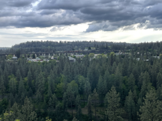
Neighborhoods in Spokane, Washington are officially grouped by the Spokane City Council into three main city council districts: 1, 2, and 3. Each city council district contains multiple, official neighborhoods that are recognized with a neighborhood council. Informally, neighborhoods are colloquially grouped by local geographical, geological, cultural, or historical features The list of neighborhoods below is organized based on the official designations by the City of Spokane. Unofficial neighborhoods and districts are listed within the official neighborhood in which they are located.

Suncrest is a census-designated place (CDP) in Stevens County, Washington, United States. Though it is not incorporated as a city or town, the CDP's population of 5,413 at the 2020 census makes Suncrest the largest community in the county. The community is located along the Spokane River 9.7 miles northwest of the city of Spokane, of which it is a exurb and bedroom community. The community experienced substantial growth starting in the mid-1980s, with gated community and suburban style development. State Route 291 is the main thoroughfare through Suncrest, as well as its main connection to the surrounding area including Spokane.

U.S. Route 395 (US 395) is a United States Numbered Highway that runs from California to the inland regions of Oregon and Washington. It travels north–south through Washington, including long concurrencies with Interstate 82 (I-82) and I-90, and connects the Tri-Cities region to Spokane and the Canadian border at Laurier.

State Route 902 (SR 902), also named the Gold Star Memorial Highway, is a state highway located entirely in Spokane County, Washington, United States. It forms a 12-mile (19 km) loop that connects Medical Lake and Eastern State Hospital to Interstate 90 (I-90) at both ends. The highway has existed since at least 1931, and before the 1964 state highway renumbering, it was numbered Secondary State Highway 11D.

Marshall is an unincorporated community in Spokane County, Washington, United States. Named in 1880 for early settler William H. Marshall, Marshall has a post office with ZIP code 99020.
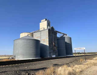
Espanola is an unincorporated community, in Spokane County, Washington, United States. The current name was adopted in the year 1900. As of 2021 the community of Espanola is little more than a handful of buildings and a grain elevator surrounded by farms.

Chief Garry Park is a neighborhood in Spokane, Washington. It is located immediately south of the Spokane River. It is named for Spokane Garry and a park that has taken his name. The neighborhood was first established in 1912 but it wasn't until 1932 that it was officially named for Chief Garry.

East Central is a neighborhood in Spokane, Washington. As the name suggests, it is on the east side of Spokane and centrally located. The official neighborhood is expansive and covers multiple areas considered by locals to be independent neighborhoods, such as the Sprague Union District on East Sprague Avenue, the South Perry District, the Underhill Park area and the University District on the eastern fringe of Downtown Spokane.

Latah/Hangman is a neighborhood in Spokane, Washington.
Grandview/Thorpe is a neighborhood in Spokane, Washington. Located in southwestern Spokane, the neighborhood takes its name from two roads that pass through. Grandview Boulevard, so named because of its location at the top of a ridge from which large swaths of Spokane, the Spokane Valley and surrounding mountains to the north and east such as Mount Spokane, can be seen, is located in the northern part of the neighborhood. Thorpe Road traverses a gully in the central and southern portion of the neighborhood.
West Hills is a neighborhood in Spokane, Washington. As the name suggests, the neighborhood is located on hillsides to the west of downtown Spokane. The neighborhood also extends far to the west along the West Plains to incorporate the Spokane International Airport and surrounding land. As the city has grown over the decades, the West Hills neighborhood has expanded uphill and onto the plains to the west. That history of incremental growth, combined with the hilly topography of the area cut by numerous watercourses, has broken up the neighborhood into multiple, distinct areas with swaths of undeveloped land mixed in between.
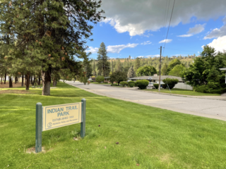
Balboa/South Indian Trail is a neighborhood in Spokane, Washington located on the northwestern side of the city. The neighborhood is largely composed of single-family residential areas that were developed after being annexed into the city in the 1950s. The neighborhood is situated on tableland above a steep bluff rising from the Spokane River to the west, that then rises up a more developed bluff towards Five Mile Prairie which is located above the neighborhood to the north and east.

Shiloh Hills is a neighborhood in Spokane, Washington, located on the far northeastern side of the city. It is one of the newer areas of the city, initially annexed in the late 1960s with growth continuing into the 21st century. The neighborhood is home to residential, commercial and industrial districts as well as multiple regionally important transportation corridors such as the Division Street "Y".
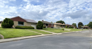
Northwest is a neighborhood in Spokane, Washington, located in the northwestern portion of the city. Largely single-family residential, Northwest is also home to Spokane's VA Medical Center, the Dwight Merkel Sports complex, a large public sports facility, and portions of Riverside State Park along the Spokane River. The neighborhood contains developments that span from the post-World War II housing boom in the east to more contemporary, suburban-style developments in the west. It was also home to Joe Albi Stadium from 1950 until 2022, which served as the Spokane region's main high school sports stadium over its seven decades of use.


