Red House is a town in Cattaraugus County, New York, United States. As of the 2020 census, the town population was 30, making it the least populous town in the state. The town is on the south edge of Cattaraugus County, south of the city of Salamanca.
Fort Hunt is a census-designated place (CDP) in Fairfax County, Virginia, United States. The area is named after Fort Hunt, which was built on the bank of the Potomac River in 1897 to defend Washington, D.C. from naval attack and is now a public park. The area is also notable for its high population of senior citizens and for being one of the first suburbs in wealthy Fairfax County. The population was 17,231 at the 2020 census.

Colville is a city in Stevens County, Washington, United States. The population was 4,917 at the 2020 census. It is the county seat of Stevens County.

Northport is a town in Stevens County, Washington, United States. The population was 297 at the 2020 census.

Fort Walla Walla is a United States Army fort located in Walla Walla, Washington. The first Fort Walla Walla was established July 1856, by Lieutenant Colonel Edward Steptoe, 9th Infantry Regiment. A second Fort Walla Walla was occupied September 23, 1856. The third and permanent military Fort Walla Walla was built in 1858 and adjoined Steptoeville, now Walla Walla, Washington, a community that had grown up around the second fort. An executive order on May 7, 1859 declared the fort a military reservation containing 640 acres devoted to military purposes and a further 640 acres each of hay and timber reserves. On September 28, 1910 soldiers from the 1st Cavalry lowered the flag closing the fort. In 1917, the fort briefly reopened to train men of the First Battalion Washington Field Artillery in support of action in World War I. In 1921, the fort and property were turned over to the Veterans Administration where 15 original buildings from the military era remain. Today, the complex contains a park, a museum, and the Jonathan M. Wainright Memorial VA Medical Center.

Addy is an unincorporated community and census-designated place in Stevens County, Washington, United States. It is located on the Colville River and U.S. Route 395 between Colville to the north and Chewelah to the south.
Mullan Road was the first wagon road to cross the Rocky Mountains to the Inland of the Pacific Northwest. It was built by U.S. Army troops under the command of Lt. John Mullan, between the spring of 1859 and summer 1860. It led from Fort Benton, which at the time was in the Dakota Territory, then Idaho Territory from July 1863, and into Montana Territory beginning in May 1864. The road eventually stretched all the way from Fort Walla Walla, Washington Territory, near the Columbia River to the navigational head of the Missouri River, which at the time was the farthest inland port in the world). The road previewed the route approximately followed by modern-day Interstate 15 and Interstate 90 through present-day Montana, Idaho, and Washington.
The Coeur d'Alene War of 1858, also known as the Spokane-Coeur d'Alene-Pend d'oreille-Paloos War, was the second phase of the Yakima War, involving a series of encounters between the allied Native American tribes of the Skitswish, Kalispell, Spokane, Palouse and Northern Paiute against United States Army forces in Washington and Idaho.
Colgate is an unincorporated community in Washington County, Wisconsin, United States, straddling the county line with Waukesha County. Colgate is located partially in the village of Richfield, and the village of Lisbon. Its ZIP Code is 53017. The population is around 300, up from about 50 in 1983.

The history of Spokane, Washington in the northwestern United States developed because Spokane Falls and its surroundings were a gathering place for numerous cultures for thousands of years. The area's indigenous people settled there due to the fertile hunting grounds and abundance of salmon in the Spokane River. The first European to explore the Inland Northwest was Canadian explorer-geographer David Thompson, working as head of the North West Company's Columbia Department. At the nexus of the Little Spokane and the Spokane, Thompson's men built a new fur trading post, which is the first long-term European settlement in Washington state.

Dilley is an unincorporated community in Washington County, Oregon, United States. It is located south of Forest Grove and north of the city of Gaston on Oregon Route 47 in the Portland metropolitan area. Settled in the late 1840s, the community was platted in 1874 after the arrival of the railroad.
Hell Gate is a ghost town at the western end of the Missoula Valley in Missoula County, Montana, United States. The town was located on the banks of the Clark Fork River roughly five miles downstream from present-day Missoula near what is now Frenchtown.
The Department of the Columbia was a major command (Department) of the United States Army during the 19th century.
William Parkhurst Winans was crucial for the development of parts of Eastern Washington, particularly Stevens County, Walla Walla, and Fort Colville. He founded Farmer's Savings Bank, and was the president until he died in 1917. He was also a member of the board of directors of First National Bank. In addition to his involvement with the bank system, Winans was a clerk in several locations throughout the region, and so is personally responsible for the majority of the records of the Colville Indians and others in the region, as well as the records of the financial dealings in the late 19th century and the early 20th century. Winans played an important role in keeping records of Indians because he was named Industrial Instructor for Indians in 1869 and Superintendent of Indian Affairs in 1870. In addition to those offices, Winans took multiple censuses of Indian populations, including the Okanagans, Calispels, San Poils, Nespelems, Senijexsees, Wenatchees, Isle d'Pierres, Mishouies, Spokanes, and the Swielpees. He was a historian himself, and wrote several histories of the region, including a book, Stevens County, Washington, its creation, addition, subtraction and division. Several of his works were given to institutions such as Harvard University and Washington State University. Eastern Washington, particularly Stevens County and Walla Walla, would not be the same if William Parkhurst Winans had not been there with his business and record-keeping skills. As the Old Walla Walla County, Washington records, "No history of Walla Walla would be complete without extended reference to William Parkhurst Winans, who was an octogenarian at the time of his demise. He had long been identified with the northwest, and his life was one of great usefulness and activity." By the end of his life, Winans was an essential part of the Walla Walla community due to his hard work and involvement in the fields of business, education, Indian affairs, and the church.

Fort Davis is an unincorporated community in Macon County, Alabama, United States, located on U.S. Route 29, 12.9 miles (20.8 km) south of Tuskegee. Fort Davis has a post office with ZIP code 36031, which opened on June 4, 1891.

Fort Colville was a U.S. Army post in the Washington Territory located three miles (5 km) north of current Colville, Washington. During its existence from 1859 to 1882, it was called "Harney's Depot" and "Colville Depot" during the first two years, and finally "Fort Colville". Brigadier General William S. Harney, commander of the Department of Oregon, opened up the district north of the Snake River to settlers in 1858 and ordered Brevet Major Pinkney Lugenbeel, 9th Infantry Regiment to establish a military post to restrain the Indians lately hostile to the U.S. Army's Northwest Division and to protect miners who flooded into the area after first reports of gold in the area appeared in Western Washington newspapers in July 1855.
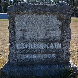
The Tshimakain Mission started in September 1838, with the arrival of Congregationalist missionaries Cushing and Myra Fairbanks Eells and Elkanah and Mary Richardson Walker to the area along Chamokane Creek at the community of Ford, Washington. Fort Colvile Chief Factor Archibald McDonald recommended the area to Eells and Walker on their first visit to the area.
Monticello is an unincorporated community located in Sierra County, New Mexico, United States. Monticello is located on Alamosa Creek, 22 miles (35 km) northwest of Truth or Consequences. Monticello has a post office with ZIP code 87939.
The Fort Walla Walla–Fort Colville Military Road was built in June 1859 to connect the Walla Walla area with its fairly easy access to the Columbia River to the mountainous area of the Huckleberry and Selkirk Mountains of current Northeast Washington and the Inland Northwest. Brigadier General William S. Harney, commander of the Department of Oregon, opened up the district north of the Snake River to settlers in 1858 and ordered Brevet Major Pinkney Lugenbeel, 9th Infantry Regiment to establish a U.S. Army post to restrain the Indians perceived as hostile to the U.S. Army's Northwest Division and to protect miners who traveled to the area after first reports of gold in the area appeared in Western Washington newspapers in July 1855.

