Biggs Junction, Oregon

Last updated

Biggs Junction, Oregon
Biggs Junction Nu-Vu Motel (2) (6698357183).jpg
Biggs Nu-Vu Motel
Sherman County Oregon Incorporated and Unincorporated areas Biggs Junction Highlighted.svg
Location of Biggs Junction, Oregon
Coordinates: 45°40′9″N120°50′11″W / 45.66917°N 120.83639°W / 45.66917; -120.83639
Country United States
State Oregon
County Sherman
Area
[1]
  Total0.89 sq mi (2.30 km2)
  Land0.89 sq mi (2.30 km2)
  Water0.00 sq mi (0.00 km2)
Elevation
220 ft (67 m)
Population
 (2020) [2]
  Total5
  Density5.64/sq mi (2.18/km2)
Time zone UTC-8 (Pacific (PST))
  Summer (DST) UTC-7 (PDT)
ZIP code
97065
Area codes 458 and 541
FIPS code 41-06400 [3]
GNIS feature ID1117690 [4]

Biggs Junction is an unincorporated community in Sherman County, Oregon, United States. [5] For statistical purposes, the United States Census Bureau has defined Biggs Junction as a census-designated place (CDP). The census definition of the area may not precisely correspond to local understanding of the area with the same name.

Contents

Biggs Junction is located on the south side of the Columbia River at the junction of Interstate 84/U.S. 30 and U.S. 97 where it crosses the Sam Hill Memorial Bridge over the river from Washington. [6] The population was 22 at the 2010 census. [7]

History

Biggs is a station on the Union Pacific Railroad (UP) at what was once a junction with the UP's Grass Valley line to Kent that has since been abandoned. [8] [9] Biggs was named for a nearby landowner, W. H. Biggs, who settled in Sherman County in 1880. [8] W. H. Biggs was born on May 12, 1831; he was from Ohio. [8] The rail line was originally owned by the Oregon Railway and Navigation Company (OR&N). In 1885 the OR&N station at Biggs was called Spanish Hollow, after the canyon that opens on the river there. [8] The canyon was said to be named because a Spanish ox died there in the days of the Oregon Trail, which runs parallel to U.S. 97. [8] [10] [11] [12] Biggs is where travelers on the Oregon Trail would first see the Columbia River after their overland journey. [13] The current community of Biggs Junction was named for the station, which is less than a mile west of the current junction, and its location at the intersection of I-84 and U.S. 97. [8] [14] Biggs post office was established in 1884 and closed in 1954. [8]

Geography

According to the United States Census Bureau, the CDP has a total area of 0.8 square miles (2.1 km2), all land. [15]

Biggs Junction is across the Columbia River from Maryhill, Washington. [6]

Demographics

Historical population
CensusPop.Note
2020 5
U.S. Decennial Census [16] [2]

As of the census [3] of 2000, there were 50 people, 20 households, and 12 families residing in the CDP. The population density was 59.6 people per square mile (23.0 people/km2). There were 22 housing units at an average density of 26.2 per square mile (10.1/km2). The racial makeup of the CDP was 68.00% White, 6.00% Asian, 26.00% from other races. Hispanic or Latino of any race were 26.00% of the population.

There were 20 households, out of which 25.0% had children under the age of 18 living with them, 60.0% were married couples living together, and 40.0% were non-families. 40.0% of all households were made up of individuals, and 5.0% had someone living alone who was 65 years of age or older. The average household size was 2.50 and the average family size was 3.50.

In the CDP, the population was spread out, with 24.0% under the age of 18, 10.0% from 18 to 24, 26.0% from 25 to 44, 30.0% from 45 to 64, and 10.0% who were 65 years of age or older. The median age was 43 years. For every 100 females, there were 85.2 males. For every 100 females age 18 and over, there were 90.0 males.

The median income for a household in the CDP was $19,167, and the median income for a family was $66,250. Males had a median income of $40,750 versus $18,750 for females. The per capita income for the CDP was $19,532. Some 21.4% of families and 22.5% of the population were living below the poverty line, including no one under eighteen and none of those over 64.

Economy

Biggs Junction (right) at the approach to the Sam Hill Memorial Bridge over the Columbia River SamHillMemorialBridge.jpg
Biggs Junction (right) at the approach to the Sam Hill Memorial Bridge over the Columbia River

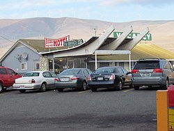
The community's major business is that of a rest and refueling stop for traffic along the two major highways. [17] [18] It is one of the largest truck stops on the Oregon section of I-84. [18]

Biggs Junction is an important wheat shipping point, with grain storage elevators and facilities for shipping wheat by river barge and rail. [9] [17]

The Biggs Junction area is known for being a source and the point of discovery of Biggs jasper, a semi-precious gemstone. [19] The jasper was originally used by the local Native Americans and was rediscovered in 1964 during the building of I-84 by road crews who were helping rebuild local bridges after the Christmas flood of that year. [19]

See also

Related Research Articles

<span class="mw-page-title-main">Wasco County, Oregon</span> County in Oregon, United States

Wasco County is one of the 36 counties in the U.S. state of Oregon. As of the 2020 census, the population was 25,213. Its county seat is The Dalles. The county is named for a local tribe of Native Americans, the Wasco, a Chinook tribe who live on the south side of the Columbia River. It is near the Washington state line. Wasco County comprises The Dalles Micropolitan Statistical Area.

<span class="mw-page-title-main">Sherman County, Oregon</span> County in Oregon, United States

Sherman County is one of the 36 counties in the U.S. state of Oregon. As of the 2020 census, the population was 1,870, making it the second-least populous county in Oregon after nearby Wheeler. The county seat is Moro, and the largest city is Wasco. The county is named for William Tecumseh Sherman, a Union general in the American Civil War.

<span class="mw-page-title-main">San Pierre, Indiana</span> Census-designated place in Indiana, United States

San Pierre is a census-designated place (CDP) in Railroad Township, Starke County, in the U.S. state of Indiana. The population was 144 at the 2010 census.

<span class="mw-page-title-main">Oak Grove, Oregon</span> Unincorporated community in the state of Oregon, United States

Oak Grove is an unincorporated community in Clackamas County, Oregon, United States, in the Portland metropolitan area. For statistical purposes, the United States Census Bureau has defined Oak Grove as a census-designated place (CDP). The census definition of the area may not precisely correspond to local understanding of the area with the same name. The population was 16,629 at the 2010 census.

<span class="mw-page-title-main">Tri-City, Oregon</span> Unincorporated community in the state of Oregon, United States

Tri-City is a census-designated place (CDP) and unincorporated community in Douglas County, Oregon, United States. The population was 3,931 at the 2010 census. The community in Missouri Bottom near the Umpqua River is named for the three cities among which it is centered: Myrtle Creek, Canyonville and Riddle. The Tri City School District probably originated the name, which was later adopted by the local sewer district and the former Tri City State Airport.

<span class="mw-page-title-main">Odell, Oregon</span> Unincorporated community in the state of Oregon, United States

Odell is an unincorporated community and census-designated place (CDP) in Hood River County, Oregon, United States. Odell was named for an early pioneer, William Odell, a native of Tennessee by way of California, who settled in the area in 1861. The population was 2,255 as of the 2010 census.

<span class="mw-page-title-main">Parkdale, Oregon</span> Unincorporated community in the state of Oregon, United States

Parkdale is an unincorporated community and census-designated place (CDP) in Hood River County, Oregon, United States. As of the 2010 census, the population was 311, up from 266 at the 2000 census.

<span class="mw-page-title-main">White City, Oregon</span> Unincorporated community in the state of Oregon, United States

White City is an unincorporated community and census-designated place (CDP) in Jackson County, Oregon, United States. The population was 7,975 at the 2010 census, up from 5,466 at the 2000 census. White City is about 9 miles (14 km) north of the center of Medford and 4 miles (6 km) south of Eagle Point.

<span class="mw-page-title-main">Warm Springs, Oregon</span> Unincorporated community in the state of Oregon, United States

Warm Springs is a census-designated place (CDP) and an unincorporated community in Jefferson County, Oregon, United States. Located on the Warm Springs Indian Reservation, the community is also known as the "Warm Springs Agency". The population was 2,945 at the 2010 census, up from 2,431 at the 2000 census.

<span class="mw-page-title-main">Redwood, Oregon</span> Unincorporated community in the state of Oregon, United States

Redwood is a census-designated place (CDP) in Josephine County, Oregon, United States. The population was 2,627 at the 2010 census, down from 5,844 at the 2000 census as it has lost territory to the neighboring city of Grants Pass.

<span class="mw-page-title-main">Rose Lodge, Oregon</span> Unincorporated community in the state of Oregon, United States

Rose Lodge is a census-designated place (CDP) and unincorporated community in Lincoln County, Oregon, United States, along the 45th parallel. The population was 1,894 at the 2010 census.

<span class="mw-page-title-main">Brooks, Oregon</span> Unincorporated community in the state of Oregon, United States

Brooks is an unincorporated community in Marion County, Oregon, United States. For statistical purposes, the United States Census Bureau has defined Brooks as a census-designated place (CDP). The census definition of the area may not precisely correspond to local understanding of the area with the same name. As of the 2020 census the population was 472. Brooks is part of the Salem Metropolitan Statistical Area.

<span class="mw-page-title-main">Wasco, Oregon</span> City in Oregon, United States

Wasco is a city in Sherman County, Oregon, United States. The population was 410 at the 2010 census.

<span class="mw-page-title-main">Oceanside, Oregon</span> Unincorporated community in Oregon, United States

Oceanside is a census-designated place (CDP) and unincorporated community in Tillamook County, Oregon, United States. The population was 361 at the 2010 census. Oregon Route 131's northern terminus is in the community, which is just north of Netarts. Symons State Park is in Oceanside, while Three Arch Rocks National Wildlife Refuge lies just offshore.

<span class="mw-page-title-main">Pine Hollow, Oregon</span> Unincorporated community in the state of Oregon, United States

Pine Hollow is a census-designated place (CDP) and unincorporated community in Wasco County, Oregon, United States. It surrounds Pine Hollow Reservoir. The CDP population was 424 at the 2000 census.

<span class="mw-page-title-main">Buna, Texas</span> Census-designated place in Texas, United States

Buna is an unincorporated community and census-designated place (CDP) in Jasper County, Texas, United States. The population was 2,137 at the 2020 census.

<span class="mw-page-title-main">Junction City, Washington</span> Census-designated place in Washington, United States

Junction City is a census-designated place (CDP) in Grays Harbor County, Washington, United States. The population was 18 at the 2010 census.

<span class="mw-page-title-main">Lyle, Washington</span> Census-designated place in Washington, United States

Lyle is an unincorporated community and census-designated place (CDP) in Klickitat County, Washington, United States. The population was 499 at the 2010 census.

<span class="mw-page-title-main">Maryhill, Washington</span> Census-designated place in Washington, United States

Maryhill is an unincorporated community and census-designated place (CDP) in Klickitat County, Washington, United States. The population was 58 at the 2010 census, down from 98 at the 2000 census.

Fort Hill is an unincorporated community in Polk and Yamhill counties in Oregon, United States. It is located about a mile east of Spirit Mountain Casino on Oregon Route 22 near the South Yamhill River. For statistical purposes, the United States Census Bureau has defined Fort Hill as a census-designated place (CDP). The census definition of the area may not precisely correspond to local understanding of the area with the same name. The hill of the same name, located just east of Valley Junction, was the site of a blockhouse built by settlers in 1855–1856. The blockhouse became part of Fort Yamhill, and was later moved to Grand Ronde Agency and is now located in Dayton.

References

  1. "ArcGIS REST Services Directory". United States Census Bureau. Retrieved October 12, 2022.
  2. 1 2 "Census Population API". United States Census Bureau. Retrieved October 12, 2022.
  3. 1 2 "U.S. Census website". United States Census Bureau . Retrieved January 31, 2008.
  4. "US Board on Geographic Names". United States Geological Survey. October 25, 2007. Retrieved January 31, 2008.
  5. "Biggs Junction". Geographic Names Information System . United States Geological Survey, United States Department of the Interior. November 28, 1980. Retrieved February 14, 2011.
  6. 1 2 Oregon Atlas & Gazetteer (7th ed.). Yarmouth, Maine: DeLorme. 2008. p. 72. ISBN   978-0-89933-347-2.
  7. American FactFinder – Results [ dead link ]
  8. 1 2 3 4 5 6 7 McArthur, Lewis A.; McArthur, Lewis L. (2003) [1928]. Oregon Geographic Names (7th ed.). Portland, Oregon: Oregon Historical Society Press. pp. 81, 899. ISBN   978-0875952772.
  9. 1 2 Fruin, Jerry E. (July 1992). "A Summary of Research Studies on the Community Impacts of Rail Abandonment in the Midwest" (PDF). The Department of Agricultural and Applied Economics, University of Minnesota College of Agriculture. pp. 25–29. Retrieved February 14, 2011.
  10. "Spanish Hollow". Geographic Names Information System . United States Geological Survey, United States Department of the Interior. November 28, 1980. Retrieved February 14, 2011.
  11. Writers' Program of the Work Projects Administration in the State of Oregon (1940). Oregon: End of the Trail. American Guide Series. Portland, Oregon: Binfords & Mort. p.  388. OCLC   4874569.
  12. Note: There was a Spanish Hollow post office from 1870 to 1882 at what is now Wasco
  13. Friedman, Ralph (2002) [1993]. The Other Side of Oregon (2nd ed.). Caldwell, Idaho: The Caxton Printers, Ltd. p. 60. ISBN   0-87004-352-8.
  14. "Biggs". Geographic Names Information System . United States Geological Survey, United States Department of the Interior. November 28, 1980. Retrieved February 14, 2011.
  15. "US Gazetteer files: 2010, 2000, and 1990". United States Census Bureau. February 12, 2011. Retrieved April 23, 2011.
  16. "Census of Population and Housing". Census.gov. Retrieved June 4, 2016.
  17. 1 2 "Agri-Business: Biggs, Oregon". Sherman County, Oregon. Retrieved February 14, 2011.
  18. 1 2 Friedman, Ralph (1990). In Search of Western Oregon (2nd ed.). Caldwell, Idaho: The Caxton Printers, Ltd. p.  611. ISBN   0-87004-332-3.
  19. 1 2 Rhode, Dale (November 2007). "Biggs Picture Jasper: A Legacy is Born" (PDF). Northwest Newsletter. Northwest Federation of Mineralogical Societies. 47 (4): 11. Archived from the original (PDF) on November 4, 2010. Retrieved February 14, 2011.