Klondike, Oregon | |
|---|---|
 Klondike, Oregon  Klondike, Oregon | |
| Coordinates: 45°34′59″N120°36′50″W / 45.583°N 120.614°W | |
| Country | United States |
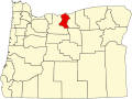
| State | Oregon |
| County | Sherman |
| Elevation | 1,558 ft (475 m) |
| Time zone | UTC-8 (Pacific (PST)) |
| • Summer (DST) | UTC-7 (PDT) |
| ZIP code | 97065 |
| Area codes | 458 and 541 |
Klondike is an unincorporated community in Sherman County, Oregon, United States. [1] It is near the Wasco, Oregon site of the Klondike III Wind Project, Oregon's largest wind energy farm with 176 turbines for wind energy. [2]