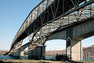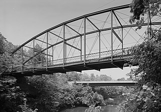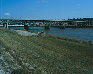
The Lewis and Clark Bridge is a cantilever bridge that spans the Columbia River between Longview, Washington, and Rainier, Oregon. At the time of its completion, it had the longest cantilever span in the United States.

The Astoria–Megler Bridge is a steel cantilever through-truss bridge in the Pacific Northwest region of the United States that spans the lower Columbia River. It carries a section of U.S. Route 101 from Astoria, Oregon, to Point Ellice near Megler, Washington. Opened in 1966, it is the longest continuous truss bridge in North America.

The Frisco Bridge, previously known as the Memphis Bridge, is a cantilevered through truss bridge carrying a rail line across the Mississippi River between West Memphis, Arkansas, and Memphis, Tennessee.

The Tower Bridge is a vertical lift bridge across the Sacramento River, linking West Sacramento in Yolo County to the west, with the capital of California, Sacramento, in Sacramento County to the east. It has also been known as M Street Bridge. It was previously a part of U.S. Route 40 until that highway was truncated to east of Salt Lake City as well as US Route 99W, which served the western portion of the Sacramento Valley from Sacramento to Red Bluff. The bridge is maintained by the California Department of Transportation as part of State Route 275 and connects West Capitol Avenue and Cabaldon Parkway in West Sacramento with the Capitol Mall in Sacramento.

State Route 285 (SR 285) is a short state highway serving Douglas and Chelan counties, located in the U.S. state of Washington. The highway serves Wenatchee and runs 5 miles (8 km) from an interchange with State Route 28 (SR 28) in East Wenatchee to Downtown Wenatchee, crossing the Columbia River on the Senator George Sellar Bridge. After traversing downtown, the highway ends at an interchange with U.S. Route 2 (US 2) and US 97 north of the Wenatchee River in Sunnyslope.

The Beverly Railroad Bridge is a historic railroad bridge that now carries hikers, bicyclists, and pedestrians over the Columbia River near Beverly, Washington, United States. It was constructed by the Chicago, Milwaukee, St. Paul and Pacific Railroad in 1909 during its Pacific Extension. In 1906, The Milwaukee Road began construction on its transcontinental rail line from Chicago, Illinois to Tacoma, Washington, which was completed three years later.

The Umatilla Bridge is the collective name for a pair of bridges in the northwest United States, carrying Interstate 82/U.S. Route 395 (I-82/US 395) across the Columbia River at the Washington–Oregon border. The older bridge opened in July 1955 and is a steel through truss cantilever bridge and carries southbound traffic. Northbound traffic and pedestrians travel on the newer concrete arch bridge, opened in 1988.

The 19th Street Bridge is a two-span through Pratt truss road bridge in Denver, Colorado, over the South Platte River, now used for pedestrians. It was built in 1888 to replace a wooden structure and carried automobile traffic until 1986. The bridge is listed on the National Register of Historic Places.

The Kettle Falls Bridges is the collective name for a pair of steel cantilever bridges carrying State Route 20/U.S. Route 395 and the Kettle Falls International Railway across the Columbia River at Kettle Falls, Washington. The south bridge carries motor vehicle traffic while the similar northern span is used for rail.

The Lover's Leap Bridge is a wrought-iron lenticular truss bridge over the Housatonic River located in Lovers Leap State Park in New Milford, Connecticut. Built in 1895 by the Berlin Iron Bridge Company, it is one of the last bridges built by the company and is a particularly ornate example of its work. It was listed on the National Register of Historic Places in 1976 and is now open only for foot traffic.

The Grand Coulee Bridge, or Columbia River Bridge at Grand Coulee Dam, is a through-cantilever steel truss bridge built in 1934–35. It carries State Route 155 across the Columbia River immediately below Grand Coulee Dam, near the city of Grand Coulee, Washington. It was added to the National Register of Historic Places in 1982.

The Yosemite Valley Bridges are eight bridges in the Yosemite Valley of Yosemite National Park, most of them spanning the Merced River. Five of them were built in 1928, with the remainder built between 1921 and 1933. The bridges feature a concrete structure faced with local stone, in an elliptical or three-centred arch configuration. They are notable for their uniform character and for their conformance to tenets of the National Park Service rustic style. Design work for the seven newer bridges was by George D. Whittle of the San Francisco District Office of the U.S. Bureau of Public Roads for the National Park Service. Concrete bridges were chosen at the urging of Thomas Chalmers Vint of the Park Service, in lieu of alternative designs for steel truss bridges, or suspension bridges suggested by the park superintendent.

The Senator George Sellar Bridge at Wenatchee, Washington was built in 1950 as the "Columbia River Bridge" to carry U.S. Route 2 across the Columbia River.

The Northport Bridge spans the Columbia River near Northport, Washington, close to the border with Canada. The steel cantilever through-truss bridge replaced an 1897 timber bridge, and was opened in 1951. It carries Washington State Route 25. It is one of a series of similar bridges built at about the same time, including the Grand Coulee Bridge and the Kettle Falls Bridges.

The Jefferson Street Viaduct is a historic structure located in Ottumwa, Iowa, United States. The riveted Warren deck truss bridge was completed in 1936. It was listed on the National Register of Historic Places in 1998 as a part of the Highway Bridges of Iowa MPS.

The Cameron Suspension Bridge crosses the Little Colorado River at Cameron, Arizona, United States.

The Newport Bridge is a historic cantilevered Warren truss bridge over the White River in Newport, Arkansas. Built in 1930 to carry U.S. Route 67 (US 67), the road it carries is now designated Arkansas Highway 367 (AR 367) after the former highway was relocated. The main bridge is 400 feet (120 m) long, with approaches from the west of 1,278 feet (390 m) and the south of 911 feet (278 m). It has cantilevered arms 138 feet (42 m) long supported by concrete piers, with a suspended Warren truss span of 125 feet (38 m). Designed by Ira G. Hedrick, it is one of three such bridges in the state.

The Ocean-to-Ocean Bridge is a through truss bridge spanning the Colorado River in Yuma, Arizona. Built in 1915, it was the first highway crossing of the lower Colorado and is the earliest example of a through truss bridge in Arizona. It is also the only example of a Pennsylvania truss within Arizona. Originally the bridge carried the transcontinental Ocean-to-Ocean Highway and later carried its successor, US 80 until a new bridge was built to the west in 1956. Between 1988 and 2001, the bridge was closed to vehicular traffic and only traversable by pedestrians and bicyclists. After a major restoration, the bridge was rehabilitated and reopened to vehicular traffic in 2002, with a re-dedication by the Quechan nation and Yuma Crossing National Heritage Area. The bridge became part of Historic US 80 in 2018.

The Jeffersonville Bridge is a steel girder bridge carrying Vermont Route 108 across the Lamoille River, just north of the village of Jeffersonville, Vermont. It was built in 2014, replacing a Parker through truss bridge built in 1931; the latter bridge was listed on the National Register of Historic Places in 1991.

The East Navidad River Bridge, also known as the State Highway 3 Bridge at East Navidad River, is a historic concrete bridge that carries FM 1579 across the East Navidad River about 3.4 miles (5.5 km) east of Schulenberg in Fayette County, Texas. The 199-foot-long (61 m) cantilever bridge has a 70-foot (21 m) center span. Concrete piers and abutments support the two cantilever arms. The total width of the bridge is 21.17 feet (6.45 m), providing an 18-foot-wide (5.5 m) roadway. The bridge gives the appearance of an arch but is in fact two cantilevered arms joined in the center of the main span and anchored and countered at the ends. Concrete piers with skewed abutments provide support.


