White Salmon | |
---|---|
White Salmon, Washington | |
Nickname: The Land Where The Sun Meets The Rain | |
Coordinates: 45°43′44″N121°29′1″W / 45.72889°N 121.48361°W | |
Country | United States |
State | Washington |
County | Klickitat |
Area | |
• Total | 1.54 sq mi (3.98 km2) |
• Land | 1.54 sq mi (3.98 km2) |
• Water | 0.00 sq mi (0.00 km2) |
Elevation | 623 ft (190 m) |
Population | |
• Total | 2,485 |
• Estimate (2023) [3] | 2,594 |
• Density | 1,684.42/sq mi (650.36/km2) |
Time zone | UTC-8 (Pacific (PST)) |
• Summer (DST) | UTC-7 (PDT) |
ZIP code | 98672 |
Area code | 509 |
FIPS code | 53-78330 [4] |
GNIS feature ID | 1512803 [5] |
Website | City of White Salmon |
White Salmon is a city in Klickitat County, Washington, United States. It is located in the Columbia River Gorge. The population was 2,193 at the 2000 census, increased 1.4% to 2,224 at the 2010 census, and increased 11.7% to 2,485 at the 2020 census.
White Salmon was first settled in 1852 by Erastus Joslyn and his wife. [6] White Salmon was officially incorporated on June 3, 1907.
White Salmon was part of the home of the Klickitat Tribe, now a part of the Yakama Confederated Nations. The Klickitat Tribe sold some land to the Joslyns. They were generally Native advocates for the time. The area was thrown open on October 31, 1858 for white settlement after the Klickitat and Yakama lost the fight for their homelands in the Yakama War. Within the same year, the region was very rapidly and heavily settled by white immigrants making land claims. The Klickitat were forced to relocate to the Yakama Reservation. [7]
White Salmon was named after the White Salmon, a now-extinct species of salmon that lived in the Columbia River and surrounding area. [8]
White Salmon's current city government includes Mayor Marla Keethler, first elected in 2019 and re-elected to a four-year term in November 2023.
Current city council members, elected to four-year terms, include Patty Fink (Position 1), David Lindley (Position 2), Jason Hartmann (Position 3), Jim Ransier (Position 4) and Ben Giant (Position 5). [9]
White Salmon is located at 45°43′44″N121°29′1″W / 45.72889°N 121.48361°W (45.728792, -121.483557). [10]
According to the United States Census Bureau, the city has a total area of 1.22 square miles (3.16 km2), all of it land. [11]
The city is located opposite Hood River, Oregon on the Columbia River.
Climate data for White Salmon, Washington | |||||||||||||
---|---|---|---|---|---|---|---|---|---|---|---|---|---|
Month | Jan | Feb | Mar | Apr | May | Jun | Jul | Aug | Sep | Oct | Nov | Dec | Year |
Record high °F (°C) | 63 (17) | 68 (20) | 81 (27) | 90 (32) | 102 (39) | 105 (41) | 115 (46) | 108 (42) | 100 (38) | 89 (32) | 69 (21) | 66 (19) | 115 (46) |
Mean daily maximum °F (°C) | 42 (6) | 47 (8) | 55 (13) | 61 (16) | 69 (21) | 74 (23) | 82 (28) | 82 (28) | 76 (24) | 64 (18) | 50 (10) | 40 (4) | 62 (17) |
Mean daily minimum °F (°C) | 31 (−1) | 31 (−1) | 35 (2) | 39 (4) | 45 (7) | 51 (11) | 55 (13) | 54 (12) | 46 (8) | 38 (3) | 34 (1) | 30 (−1) | 41 (5) |
Record low °F (°C) | −20 (−29) | −21 (−29) | 9 (−13) | 23 (−5) | 26 (−3) | 32 (0) | 37 (3) | 36 (2) | 26 (−3) | 15 (−9) | −5 (−21) | −10 (−23) | −21 (−29) |
Average precipitation inches (mm) | 5.32 (135) | 4.06 (103) | 3.01 (76) | 1.76 (45) | 1.30 (33) | 0.87 (22) | 0.28 (7.1) | 0.31 (7.9) | 0.92 (23) | 2.29 (58) | 5.39 (137) | 5.91 (150) | 31.42 (797) |
Source: [12] |
Census | Pop. | Note | %± |
---|---|---|---|
1910 | 682 | — | |
1920 | 619 | −9.2% | |
1930 | 798 | 28.9% | |
1940 | 985 | 23.4% | |
1950 | 1,353 | 37.4% | |
1960 | 1,590 | 17.5% | |
1970 | 1,585 | −0.3% | |
1980 | 1,853 | 16.9% | |
1990 | 1,861 | 0.4% | |
2000 | 2,193 | 17.8% | |
2010 | 2,224 | 1.4% | |
2019 (est.) | 2,691 | [13] | 21.0% |
U.S. Decennial Census [14] |
At the 2010 census there were 2,224 people in 921 households, including 559 families, in the city. The population density was 1,823.0 inhabitants per square mile (703.9/km2). There were 1,039 housing units at an average density of 851.6 per square mile (328.8/km2). The racial makeup of the city was 78.8% White, 0.3% African American, 1.4% Native American, 0.9% Asian, 14.7% from other races, and 3.9% from two or more races. Hispanic or Latino of any race were 24.4%. [2]
Of the 921 households 31.5% had children under the age of 18 living with them, 45.7% were married couples living together, 10.7% had a female householder with no husband present, 4.2% had a male householder with no wife present, and 39.3% were non-families. 33.1% of households were one person and 14.3% were one person aged 65 or older. The average household size was 2.41 and the average family size was 3.09.
The median age was 38.1 years. 25.6% of residents were under the age of 18; 6.5% were between the ages of 18 and 24; 26.8% were from 25 to 44; 25.2% were from 45 to 64; and 15.8% were 65 or older. The gender makeup of the city was 48.6% male and 51.4% female.
At the 2000 census there were 2,193 people in 887 households, including 590 families, in the city. The population density was 1,759.2 people per square mile (677.4/km2). There were 948 housing units at an average density of 760.5 per square mile (292.8/km2). The racial makeup of the city was 83.08% White, 0.23% African American, 1.14% Native American, 0.73% Asian, 0.09% Pacific Islander, 12.04% from other races, and 2.69% from two or more races. Hispanic or Latino of any race were 16.83%. [4]
Of the 887 households 34.4% had children under the age of 18 living with them, 50.1% were married couples living together, 12.3% had a female householder with no husband present, and 33.4% were non-families. 29.7% of households were one person and 14.2% were one person aged 65 or older. The average household size was 2.46 and the average family size was 3.03.
The age distribution was 28.7% under the age of 18, 7.0% from 18 to 24, 28.2% from 25 to 44, 20.4% from 45 to 64, and 15.7% 65 or older. The median age was 37 years. For every 100 females, there were 93.0 males. For every 100 females age 18 and over, there were 84.7 males.
The median household income was $34,787 and the median family income was $39,653. Males had a median income of $33,021 versus $20,417 for females. The per capita income for the city was $17,995. About 13.0% of families and 16.7% of the population were below the poverty line, including 23.6% of those under age 18 and 12.8% of those age 65 or over.
Klickitat County is a county located in the U.S. state of Washington. As of the 2020 census, the population was 22,735. The county seat and largest city is Goldendale. The county is named after the Klickitat tribe.
Cypress Lakes was a former census-designated place (CDP) and current unincorporated place in Palm Beach County, Florida, United States. The population was 1,468 at the 2000 census.
Salmon is a city in Lemhi County, Idaho. The population was 3,112 at the 2010 census. The city is the county seat of Lemhi County.
Pinehurst is a city in Shoshone County, Idaho, United States. Located at the west end of the Silver Valley mining region, its population was 1,619 at the 2010 census.
Viola is a city in Sedgwick County, Kansas, United States. As of the 2020 census, the population of the city was 115.
Sidney is a town in Kennebec County, Maine, United States. The population was 4,645 at the 2020 census. Sidney was incorporated as a town on January 30, 1792. The town was named for Sir Philip Sidney, an English author. Sidney is included in the Augusta, Maine micropolitan New England City and Town Area. Since 1937, the town has been the home of the New England Music Camp.
Ocean Grove is a census-designated place (CDP) in the town of Swansea in Bristol County, Massachusetts, United States, on the north shore of Mount Hope Bay near the Cole River. The population was 2,811 at the 2010 census, and 2,904 as of the 2020 census.
Kingsford is a city in Dickinson County, Michigan, United States. Its population was 5,139 at the 2020 census, a slight increase from the 5,133 recorded at the 2010 census. It was named for the developer Edward G. Kingsford.
Ishpeming Township is a civil township of Marquette County in the U.S. state of Michigan. The population was 3,392 at the 2020 census. The city of Ishpeming is to the south, but the two are administered autonomously.
Kelliher is a city in Beltrami County, Minnesota, United States. The population was 258 at the 2020 census. Minnesota State Highway 72 is the primary route through Kelliher.
Sandusky South is an census-designated place in Perkins Township, Erie County, Ohio, United States. The population was 6,599 at the 2000 census. It was not delineated as a CDP for the 2010 census. It is part of the Sandusky, Ohio Metropolitan Statistical Area.
Bingen is a city in Klickitat County, Washington, United States. The population was 778 at the 2020 census.
Dallesport is an unincorporated community and census-designated place (CDP) in Klickitat County, Washington, United States. The population was 1,328 at the 2020 census.
Goldendale is a city and county seat of Klickitat County, Washington, United States, near the Columbia River Gorge. The population within city limits was 3,760 at the 2000 census and 3,407 at the 2010 census, a 9.4% decrease. It is situated in a primarily agricultural area and is also near Goldendale Observatory State Park. The valley in which Goldendale is located offers views of the Cascade Mountains to the west and the Simcoe Mountains to the north.
Lyle is an unincorporated community and census-designated place (CDP) in Klickitat County, Washington, United States. The population was 499 at the 2010 census.
Maryhill is an unincorporated community and census-designated place (CDP) in Klickitat County, Washington, United States. The population was 58 at the 2010 census, down from 98 at the 2000 census.
Trout Lake is an unincorporated community and census-designated place (CDP) in Klickitat County, Washington, United States. The population was 557 at the 2010 census. The town is notable for its organic dairy and herb farms, and as an access point to Mount Adams and the Gifford Pinchot National Forest.
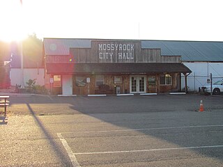
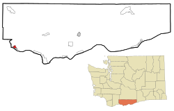
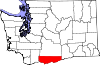
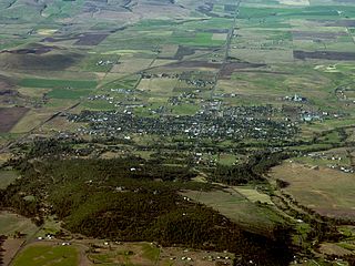
Mossyrock is a city in Lewis County, Washington, United States. The population was 768 at the 2020 census.
Buckley is a city in Pierce County, Washington, United States, founded in 1882. The population was 5,114 at the 2020 census. Buckley sits below Mount Rainier and is well known for hosting the annual Log Show.
Toppenish is a city in Yakima County, Washington. As of the 2020 census, the city population was 8,854. It is located within the Yakama Indian Reservation, established in 1855.