List of rapids of the Columbia River

Last updated

This is a list of rapids of the Columbia River , listed in upriver order. The river flows through Canada and the United States. Almost all of these rapids are now submerged in the reservoirs of dams. The list is not exhaustive; there were numerous minor rapids and riffles, many of which were never named.

Contents

Map of the Columbia drainage Basin with the Columbia River highlighted and showing the major tributaries Columbiarivermap.png
Map of the Columbia drainage Basin with the Columbia River highlighted and showing the major tributaries

Mouth to Snake River

Cascade Rapids. Hassalo running Cascades of Columbia river, May 26, 1881.JPG
Cascade Rapids.
Celilo Falls. Fishing at Celilo Falls on the Columbia River (3229034311).jpg
Celilo Falls.

Snake River to Bridgeport

The 70 mile stretch between Priest Rapids and the mouth of the Snake River (the Hanford Reach) "has the slowest current of any part of the Columbia above The Dalles". [25]

Priest Rapids. John Gates at Priest Rapids.jpg
Priest Rapids.

Bridgeport to Canada–US border

The portion of the river between Monaghan Rapids and Foster Creek Rapids was regarded as particularly hazardous. An 1893 report by the Army Corps of Engineers described the river from Monaghan Rapids to the foot of Foster Creek Rapids as "very swift and studded with rocks, and taken all in all will be found an extremely hard and dangerous if not absolutely impassable portion of the river to navigate". Over the 45 miles (72 km) from Monaghan to Foster Creek the river fell 171 feet (52 m) at low-water. Over the 10 miles (16 km) between Mah-kin Rapids and a point three miles below Parson Rapids the river fell 41 feet (12 m) at low water. The portion from White Cap Rapids to Eagle Rapids was once known as "Nespilem Canyon". The Corps' 1893 report said that over the worst 3 miles (4.8 km) stretch the river fell 22 feet (6.7 m) at low-water and 24 feet (7.3 m) at high-water, and that the speed of the current at low-water was about 10 miles per hour (16 km/h). On the possibility of navigation the Corps was pessimistic: "The fall of the river here is so great that it is certain that no system of rock removal could make the river sufficiently navigable to justify the danger and risk necessarily incurred in running boats on it." [37]

Upper Long Rapids. Upper Long Rapids, Columbia River - NARA - 298825.jpg
Upper Long Rapids.
Kettle Falls. General view of Kettle Falls of the Columbia River. This was taken on a field trip of the Spokane Camera Club.... - NARA - 298707.jpg
Kettle Falls.

Canada–US border to Revelstoke

Revelstoke to Mica Dam

Mica Dam to source at Columbia Lake

See also

Related Research Articles

<span class="mw-page-title-main">Columbia River</span> River in the Pacific Northwest of North America

The Columbia River is the largest river in the Pacific Northwest region of North America. The river forms in the Rocky Mountains of British Columbia, Canada. It flows northwest and then south into the U.S. state of Washington, then turns west to form most of the border between Washington and the state of Oregon before emptying into the Pacific Ocean. The river is 1,243 miles long, and its largest tributary is the Snake River. Its drainage basin is roughly the size of France and extends into seven states of the United States and one Canadian province. The fourth-largest river in the United States by volume, the Columbia has the greatest flow of any river entering the Pacific outside of Asia, and the 36th greatest discharge of any river in the world.

<span class="mw-page-title-main">Dallesport, Washington</span> Census-designated place in Washington, United States

Dallesport is an unincorporated community and census-designated place (CDP) in Klickitat County, Washington, United States. The population was 1,328 at the 2020 census.

<span class="mw-page-title-main">Cascades Rapids</span> Former area of rapids along the Columbia River, USA

The Cascades Rapids were an area of rapids along North America's Columbia River, between the U.S. states of Washington and Oregon. Through a stretch approximately 150 yards (140 m) wide, the river dropped about 40 feet (12 m) in 2 miles (3.2 km). These rapids or cascades, along with the many cascades along the Columbia River Gorge in this area of Oregon and Washington, gave rise to the name for the surrounding mountains: the Cascade Range.

<span class="mw-page-title-main">Columbia Plateau</span> Plateau in Washington, Oregon, and Idaho in the United States

The Columbia Plateau is a geologic and geographic region that lies across parts of the U.S. states of Washington, Oregon, and Idaho. It is a wide flood basalt plateau between the Cascade Range and the Rocky Mountains, cut through by the Columbia River.

<span class="mw-page-title-main">Owyhee River</span> River in Nevada, Idaho, and Oregon, United States

The Owyhee River is a tributary of the Snake River located in northern Nevada, southwestern Idaho and southeastern Oregon in the United States. It is 280 miles (450 km) long. The river's drainage basin is 11,049 square miles (28,620 km2) in area, one of the largest subbasins of the Columbia Basin. The mean annual discharge is 995 cubic feet per second (28.2 m3/s), with a maximum of 50,000 cu ft/s (1,400 m3/s) recorded in 1993 and a minimum of 42 cu ft/s (1.2 m3/s) in 1954.

<span class="mw-page-title-main">Clark Fork River</span> River in the U.S. states of Montana and Idaho

The Clark Fork, or the Clark Fork of the Columbia River, is a river in the U.S. states of Montana and Idaho, approximately 310 miles (500 km) long. The largest river by volume in Montana, it drains an extensive region of the Rocky Mountains in western Montana and northern Idaho in the watershed of the Columbia River. The river flows northwest through a long valley at the base of the Cabinet Mountains and empties into Lake Pend Oreille in the Idaho Panhandle. The Pend Oreille River in Idaho, Washington, and British Columbia, Canada which drains the lake to the Columbia in Washington, is sometimes included as part of the Clark Fork, giving it a total length of 479 miles (771 km), with a drainage area of 25,820 square miles (66,900 km2). In its upper 20 miles (32 km) in Montana near Butte, it is known as Silver Bow Creek. Interstate 90 follows much of the upper course of the river from Butte to Saint Regis. The highest point within the river's watershed is Mount Evans at 10,641 feet (3,243 m) in Deer Lodge County, Montana along the Continental Divide.

<span class="mw-page-title-main">Revelstoke Dam</span> Dam in Revelstoke, Canada

Revelstoke Dam, also known as Revelstoke Canyon Dam, is a hydroelectric dam spanning the Columbia River, 5 km (3.1 mi) north of Revelstoke, British Columbia, Canada. The powerhouse was completed in 1984 and has an installed capacity of 2480 MW. Four generating units were installed initially, with one additional unit (#5) having come online in 2011. The reservoir behind the dam is named Lake Revelstoke. The dam is operated by BC Hydro.

<span class="mw-page-title-main">The Dalles Dam</span> US hydroelectric dam on the Columbia River

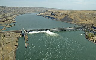
The Dalles Lock and Dam is a concrete-gravity run-of-the-river dam spanning the Columbia River, two miles (3 km) east of the city of The Dalles, Oregon, United States. It joins Wasco County, Oregon with Klickitat County, Washington, 192 miles (309 km) upriver from the mouth of the Columbia near Astoria, Oregon. The closest towns on the Washington side are Dallesport and Wishram.

<span class="mw-page-title-main">John Day Dam</span> Dam in Washington, United States

The John Day Dam is a concrete gravity run-of-the-river dam spanning the Columbia River in the northwestern United States. The dam features a navigation lock plus fish ladders on both sides. The John Day Lock has the highest lift of any U.S. lock. The reservoir impounded by the dam is Lake Umatilla, and it runs 76.4 miles (123.0 km) up the river channel to the foot of the McNary Dam. John Day Dam is part of the Columbia River Basin system of dams.

<span class="mw-page-title-main">Feather River</span> River in California, United States

The Feather River is the principal tributary of the Sacramento River, in the Sacramento Valley of Northern California. The river's main stem is about 73 miles (117 km) long. Its length to its most distant headwater tributary is just over 210 miles (340 km). The main stem Feather River begins in Lake Oroville, where its four long tributary forks join—the South Fork, Middle Fork, North Fork, and West Branch Feather Rivers. These and other tributaries drain part of the northern Sierra Nevada, and the extreme southern Cascades, as well as a small portion of the Sacramento Valley. The total drainage basin is about 6,200 square miles (16,000 km2), with approximately 3,604 square miles (9,330 km2) above Lake Oroville.

<span class="mw-page-title-main">Celilo Falls</span> Historical waterfall on the Columbia River in Washington (state), United States

Celilo Falls was a tribal fishing area on the Columbia River, just east of the Cascade Mountains, on what is today the border between the U.S. states of Oregon and Washington. The name refers to a series of cascades and waterfalls on the river, as well as to the native settlements and trading villages that existed there in various configurations for 15,000 years. Celilo was the oldest continuously inhabited community on the North American continent until 1957, when the falls and nearby settlements were submerged by the construction of The Dalles Dam. In 2019, there were calls by tribal leaders to restore the falls.

<span class="mw-page-title-main">Watts Bar Lake</span> Reservoir in Tennessee, United States

Watts Bar Lake is a reservoir on the Tennessee River created by Watts Bar Dam as part of the Tennessee Valley Authority system.

Lake Revelstoke or Revelstoke Lake or Revelstoke Lake Reservoir is an artificial lake on the Columbia River, north of the town of Revelstoke, British Columbia and south of Mica Creek. This lake is the reservoir formed by the Revelstoke Dam, which during its construction was also known as the Revelstoke Canyon Dam, inundating the Columbia's canyon in this area and the historic Dalles des Morts and some of the former gold diggings of the Big Bend Gold Rush. The dam's site is at what had been the head of river navigation by steamboat from Northport, Washington via the Arrow Lakes.

<span class="mw-page-title-main">Priest Rapids</span>

Priest Rapids was a narrow, fast-flowing stretch of the Columbia River, located in the central region of the U.S. state of Washington. It was flooded by the construction of the Priest Rapids Dam in the 1950s.

<span class="mw-page-title-main">Steamboats of the Arrow Lakes</span>

The era of steamboats on the Arrow Lakes and adjoining reaches of the Columbia River is long-gone but was an important part of the history of the West Kootenay and Columbia Country regions of British Columbia Canada. The Arrow Lakes are formed by the Columbia River in southeastern British Columbia. Steamboats were employed on both sides of the border in the upper reaches of the Columbia, linking port towns on either side of the border, and sometimes boats would be built in one country and operated in the other. Tributaries of the Columbia include the Kootenay River which rises in Canada, then flows south into the United States, then bends north again back into Canada, where it widens into Kootenay Lake. As with the Arrow Lakes, steamboats once operated on the Kootenay River and Kootenay Lake.

Dalles des Morts, also known as Death Rapids in English, was a famously violent stretch of the Columbia River upstream from Revelstoke, British Columbia, Canada, now submerged beneath the waters of Lake Revelstoke.

<span class="mw-page-title-main">Columbia Hills (Washington)</span>

The Columbia Hills are an area of hills and small mountains along the north bank of the Columbia River in Klickitat County, in south-central Washington state, US. They have a maximum elevation of 2,667 feet (813 m).

The Wood River, which flows in a southwesterly direction, is in the East Kootenay region of southeastern British Columbia. The former confluence was near the top of the Big Bend of the Columbia River. After the enlarged Kinbasket Lake formed the Mica Dam reservoir, the flow entered Wood Arm.

<span class="mw-page-title-main">Sentinel Gap</span>

Sentinel Gap is a water gap formed by the Columbia River in the Saddle Mountains, near Mattawa in Washington state. The gap is "a water gap where erosion by the Columbia River was able to keep pace with folding, faulting and uplifting across the Saddle Mountain anticline". During Ice Age floods in which waters from the Channeled Scablands found passage to the Pacific Ocean here and at Wallula Gap, this opening was "repeatedly reamed out, which probably widened and steepened the walls of the gap". Strandlines from the floods can be seen on the basalt walls of the gap.

References

  1. U.S. Geological Survey Geographic Names Information System: The Cascades (historical)
  2. Ulrich, Roberta (2007). Empty Nets: Indians, dams, and the Columbia River . Corvallis, Oregon: Oregon State University Press. p.  21. ISBN   978-0-87071-469-6.
  3. U.S. Geological Survey Geographic Names Information System: The Dalles (historical)
  4. U.S. Geological Survey Geographic Names Information System: Threemile Rapids (historical)
  5. U.S. Geological Survey Geographic Names Information System: The Dalles (historical)
  6. U.S. Geological Survey Geographic Names Information System: Fivemile Rapids (historical)
  7. U.S. Geological Survey Geographic Names Information System: Tenmile Rapids (historical)
  8. U.S. Geological Survey Geographic Names Information System: Celilo Falls (historical)
  9. U.S. Geological Survey Geographic Names Information System: Preachers Eddy
  10. U.S. Geological Survey Geographic Names Information System: Schofield Rapids (historical)
  11. U.S. Geological Survey Geographic Names Information System: Lower John Day Rapids (historical)
  12. U.S. Geological Survey Geographic Names Information System: Upper John Day Rapids (historical)
  13. 1 2 3 4 5 6 7 United States Army Corps of Engineers (1912). Report of the Chief of Engineers, U.S. Army. United States Government Printing Office. pp. 2798–2800, 2863. ISSN   0271-3845. OCLC   5168357.
  14. U.S. Geological Survey Geographic Names Information System: Indian Rapids (historical)
  15. 1 2 3 4 5 6 7 Washington Place Names Archived 2009-03-09 at the Wayback Machine , Tacoma Public Library
  16. U.S. Geological Survey Geographic Names Information System: Squally Hook Rapids (historical)
  17. 1 2 3 4 5 6 7 8 9 Freeman, Lewis Ransome (1921). Down the Columbia. New York: Dodd, Mead and company. pp.  326–329, 335–339. OCLC   1738301.
  18. U.S. Geological Survey Geographic Names Information System: Blalock
  19. U.S. Geological Survey Geographic Names Information System: Blalock Canyon
  20. U.S. Geological Survey Geographic Names Information System: Owyhee Rapids (historical)
  21. U.S. Geological Survey Geographic Names Information System: Canoe Encampment Rapids (historical)
  22. U.S. Geological Survey Geographic Names Information System: Umatilla Rapids (historical)
  23. Meinig, D.W. (1995) [1968]. The Great Columbia Plain (Weyerhaeuser Environmental Classic ed.). University of Washington Press. pp. 214, 252–253. ISBN   0-295-97485-0.
  24. "Dam the Columbia: Umatilla Rapids Association". Center for Columbia River History. Retrieved 7 October 2009.
  25. Down the Columbia, p. 320
  26. U.S. Geological Survey Geographic Names Information System: Coyote Rapids
  27. United States. War Dept (1893). "Annual reports of the War Department, Part 4". Annual Reports of the War Department: For the Fiscal Year Ended June 30. United States Government Printing Office. ISSN   1050-1274. OCLC   1777262.
  28. U.S. Geological Survey Geographic Names Information System: Priest Rapids
  29. Dorpat, Paul; Genevieve McCoy (1998). Building Washington: A History of Washington State Public Works. Tartu Publications. p. 25. ISBN   0-9614357-9-8.
  30. 1 2 Gulick, Bill (2004). Steamboats on Northwest Rivers. Caxton Press. pp. 225–228. ISBN   978-0-87004-438-0.
  31. U.S. Geological Survey Geographic Names Information System: Cabinet Rapids (historical)
  32. 1 2 United States Army Corps of Engineers (1892). "Annual report of the Chief of Engineers to the Secretary of War for the year 1892, Volume 3". Annual Report of the Chief of Engineers to the Secretary of War for the Year. United States Government Printing Office: 2716. ISSN   1050-1266. OCLC   5168701.
  33. U.S. Geological Survey Geographic Names Information System: Nixon Rapids (historical)
  34. U.S. Geological Survey Geographic Names Information System: Rock Island
  35. 1 2 Landes, Henry (1917). A Geographic Dictionary of Washington. Washington Geological Survey. pp. 132, 233. OCLC   2882774.
  36. U.S. Geological Survey Geographic Names Information System: Methow Rapids (historical)
  37. 1 2 United States Army Corps of Engineers (1893). Report of the Chief of Engineers, U.S. Army, Part 4. United States Government Printing Office. pp. 3388–3389, 3394–3396. OCLC   18063671.
  38. U.S. Geological Survey Geographic Names Information System: Reef Rapids
  39. Symons, Thomas William (1882). Report of an examination of the upper Columbia River and the territory in its vicinity in September and October, 1881, to determine its navigability, and adaptability to steamboat transportation. United States Army Corps of Engineers. United States Government Printing Office. p. 182. OCLC   13375670.
  40. Down the Columbia, p. 274
  41. United States. War Dept (1893). "Annual reports of the War Department, Part 4". Annual Reports of the War Department: For the Fiscal Year Ended June 30. United States Government Printing Office: 3389–3390. ISSN   1050-1274. OCLC   1777262.
  42. U.S. Geological Survey Geographic Names Information System: Eagle Rapids
  43. U.S. Geological Survey Geographic Names Information System: Long Rapids
  44. U.S. Geological Survey Geographic Names Information System: White Cap Rapids
  45. Down the Columbia, p. 275
  46. U.S. Geological Survey Geographic Names Information System: Parson Rapids
  47. U.S. Geological Survey Geographic Names Information System: Granite Rapids
  48. U.S. Geological Survey Geographic Names Information System: Mah-kin Rapids
  49. U.S. Geological Survey Geographic Names Information System: Nespelem Rapids
  50. 1 2 3 Down the Columbia, p. 271
  51. U.S. Geological Survey Geographic Names Information System: Equilibrium Rapids
  52. U.S. Geological Survey Geographic Names Information System: Monaghan Rapids
  53. U.S. Geological Survey Geographic Names Information System: Hell Gate Canyon
  54. U.S. Geological Survey Geographic Names Information System: Hellgate Island
  55. Report of an examination of the upper Columbia River, p. 172
  56. Report of an examination of the upper Columbia River, p. 168
  57. Down the Columbia, p. 224
  58. U.S. Geological Survey Geographic Names Information System: Rickey Rapids
  59. U.S. Geological Survey Geographic Names Information System: Kettle Falls (historical)
  60. U.S. Geological Survey Geographic Names Information System: Little Dalles
  61. United States. War Dept (1893). "Annual reports of the War Department, Part 4". Annual Reports of the War Department: For the Fiscal Year Ended June 30. United States Government Printing Office: 3385. ISSN   1050-1274. OCLC   1777262.
  62. "Waterloo Eddy". BC Geographical Names .
  63. 1 2 "Tin Cup Rapids". Trails in Time. Retrieved 10 October 2009.
  64. Down the Columbia p. 197
  65. "Tincup Rapids". BC Geographical Names .
  66. 1 2 3 "Lower Arrow Lake". BC Geographical Names .
  67. "Narrows, The". BC Geographical Names .
  68. "Upper Arrow Lake". BC Geographical Names .
  69. "Big Eddy". BC Geographical Names . and topographic maps
  70. "Revelstoke". BC Geographical Names .
  71. "Steamboat Rapids". BC Geographical Names . and topographic maps
  72. "Little Dalles Canyon". BC Geographical Names .
  73. "Eighteen Mile Rapids". BC Geographical Names .
  74. 1 2 3 4 5 6 British Columbia Department of Lands Geographic Branch (1941). "Revelstoke - Golden, Big Bend - Columbia River, 1941, Map No. 5D". Lithographed Regional Maps, Topographic Series, 1917-1952, Sheets: 5A - 5E. British Columbia Archives, Royal BC Museum. Archived from the original on 24 December 2008. Retrieved 28 November 2009.
  75. "Priest Rapids". BC Geographical Names .
  76. Down the Columbia, pp. 180-182
  77. "Death Rapids". BC Geographical Names .
  78. Down the Columbia pp. 172-173
  79. "Twelve Mile Rapids". BC Geographical Names .
  80. "Gordon Rapids". BC Geographical Names .
  81. Down the Columbia, pp. 141, 144-145
  82. Down the Columbia, pp. 151-157
  83. "Redrock Canyon Rapids". BC Geographical Names .
  84. "Yellow Creek Rapids". BC Geographical Names .
  85. "Weasel Rapids". BC Geographical Names .
  86. "Mink Rapids". BC Geographical Names .
  87. "Boulder Rapids". BC Geographical Names .
  88. "Elbow, The". BC Geographical Names .
  89. "Surprise Rapids". BC Geographical Names .
  90. Down the Columbia, pp. 114-115
  91. "Brinkmans Terror Rapids". BC Geographical Names .
  92. "Kitchins Rapids". BC Geographical Names .