Related Research Articles

The Pend Oreille River is a tributary of the Columbia River, approximately 130 miles (209 km) long, in northern Idaho and northeastern Washington in the United States, as well as southeastern British Columbia in Canada. In its passage through British Columbia its name is spelled Pend-d'Oreille River. It drains a scenic area of the Rocky Mountains along the U.S.-Canada border on the east side of the Columbia. The river is sometimes defined as the lower part of the Clark Fork, which rises in western Montana. The river drains an area of 66,800 square kilometres (25,792 sq mi), mostly through the Clark Fork and its tributaries in western Montana and including a portion of the Flathead River in southeastern British Columbia. The full drainage basin of the river and its tributaries accounts for 43% of the entire Columbia River Basin above the confluence with the Columbia. The total area of the Pend Oreille basin is just under 10% of the entire 258,000-square-mile (670,000 km2) Columbia Basin. Box Canyon Dam is currently underway on a multimillion-dollar project for a fish ladder.

The Okanogan River is a tributary of the Columbia River, approximately 115 mi (185 km) long, in southern British Columbia and north central Washington. It drains a scenic plateau region called the Okanagan Country east of the Cascade Range and north and west of the Columbia, and also the Okanagan region of British Columbia. The Canadian portion of the river has been channelized since the mid-1950s.
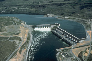
The Chief Joseph Dam is a concrete gravity dam on the Columbia River, 2.4 km (1.5 mi) upriver from Bridgeport, Washington. The dam is 877 km (545 mi) upriver from the mouth of the Columbia at Astoria, Oregon. It is operated by the USACE Chief Joseph Dam Project Office, and the electricity is marketed by the Bonneville Power Administration.

The Colville Indian Reservation is an Indian reservation in the north-central part of the U.S. state of Washington, inhabited and managed by the Confederated Tribes of the Colville Reservation, which is federally recognized. Established in 1872, the reservation currently consists of 2,825,000 acres (1,143,000 ha). It is located primarily in the southeastern section of Okanogan County and the southern half of Ferry County, but it includes other pieces of trust land in eastern Washington, including in Chelan County, just to the northwest of the city of Chelan. The reservation's name is adapted from that of Fort Colville, which was named by British colonists for Andrew Colville, a London governor of the Hudson's Bay Company.
The Confederated Tribes of the Colville Reservation is the federally recognized tribe that controls the Colville Indian Reservation, which is located in northeastern Washington, United States. It is the government for its people.

Franklin D. Roosevelt Lake is the reservoir created in 1941 by the impoundment of the Columbia River by the Grand Coulee Dam in Washington state. It is named for Franklin D. Roosevelt, who was president during the construction of the dam. Covering 125 square miles, it stretches about 150 miles (240 km) from the Canada–US border to Grand Coulee Dam, with over 600 miles (970 km) of shoreline; by surface area it is the largest lake and reservoir in Washington. It is the home of the Lake Roosevelt National Recreation Area.

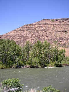
The Methow River is a tributary of the Columbia River in northern Washington in the United States. The river's 1,890-square-mile (4,900 km2) watershed drains the eastern North Cascades, with a population of about 5,000 people. The Methow's watershed is characterized by relatively pristine habitats, as much of the river basin is located in national forests and wildernesses. Many tributaries drain the large Pasayten Wilderness. An earlier economy based on agriculture is giving way to one based on recreation and tourism.

Crab Creek is a stream in the U.S. state of Washington. Named for the presence of crayfish, it is one of the few perennial streams in the Columbia Basin of central Washington, flowing from the northeastern Columbia River Plateau, roughly 5 km (3.1 mi) east of Reardan, west-southwest to empty into the Columbia River near the small town of Beverly. Its course exhibits many examples of the erosive powers of extremely large glacial Missoula Floods of the late Pleistocene, which scoured the region. In addition, Crab Creek and its region have been transformed by the large-scale irrigation of the Bureau of Reclamation's Columbia Basin Project (CBP), which has raised water table levels, significantly extending the length of Crab Creek and created new lakes and streams.

The Kettle River is a 281-kilometre (175 mi) tributary of the Columbia River in southeastern British Columbia in Canada and northeastern Washington in the United States. Its drainage basin is 10,877 square kilometres (4,200 sq mi) large, of which 8,228 square kilometres (3,177 sq mi) are in Canada and 2,649 square kilometres (1,023 sq mi) in the United States. The indigenous name of the river in the Okanagan language is nxʷyaʔłpítkʷ (Ne-hoi-al-pit-kwu.)
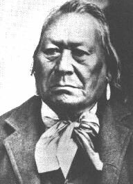
Chief Moses was a Native American chief of the Sinkiuse-Columbia, in what is now Washington State. The territory of his tribe extended approximately from Waterville to White Bluffs, in the Columbia Basin. They were often in the area around Moses Lake. The tribe numbered perhaps a few hundred individuals.
The Colville River is a 60-mile (100 km) long tributary of the Columbia River in northeastern Washington in the United States.
The Naches River is a tributary of the Yakima River in central Washington in the United States. Beginning as the Little Naches River, it is about 75 miles (121 km) long. After the confluence of the Little Naches and Bumping River the name becomes simply the Naches River. The Naches and its tributaries drain a portion of the eastern side of the Cascade Range, east of Mount Rainier and northeast of Mount Adams. In terms of discharge, the Naches River is the largest tributary of the Yakima River.
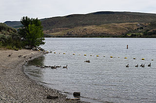
The Sanpoil River is a tributary of the Columbia River, in the U.S. state of Washington. The term Sanpoil is from the Okanagan term [snpʕʷílx], meaning "people of the gray country", or "gray as far as one can see".
The Sanpoil are a Native American people of the U.S. state of Washington. They are one of the Salish peoples and are one of the twelve members of the Confederated Tribes of the Colville Reservation.

The Nespelem people belong to one of twelve aboriginal Confederated Tribes of the Colville Indian Reservation in eastern Washington. They lived primarily near the banks of the Nespelem River, an Upper Columbia River tributary, in an area now known as Nespelem, Washington, located on the Colville Indian Reservation. Alternate spellings include Nespelim or Nespilim.
The Chelan are an Interior Salish people speaking the Wenatchi dialect, though separate from that tribe. The name derives from the traditional Wenatchi name Tsi-Laan meaning "deep water".
The Colville people, or sx̌ʷyʔiɬpx, are a Native American people of the Pacific Northwest. The name Colville comes from association with Fort Colville, named after Andrew Colvile of the Hudson's Bay Company. Earlier, outsiders often called them Scheulpi, Chualpay, or Swhy-ayl-puh; the French traders called them Les Chaudières in reference to Kettle Falls. The neighboring Coeur d'Alene called them Sqhwiyi̱'ɫpmsh and the Spokane knew them as Sxʷyelpetkʷ.
Bridgeport State Park is a public recreation area located two miles east of Bridgeport, Washington, on the north shore of Rufus Woods Lake, the Columbia River reservoir created by the Chief Joseph Dam. The state park was built through a partnership between Washington State Parks and the Army Corps of Engineers after completion of the dam in 1955. The park's 25-year lease was renewed in 1990 and again in 2015. The park covers 622 acres (252 ha) which include 7,500 feet (2,300 m) of shoreline, camping areas, four miles (6.4 km) of hiking trails, and facilities for boating, fishing, swimming, and golf.
References
- 1 2 U.S. Geological Survey Geographic Names Information System: Nespelem River, USGS, GNIS
- 1 2 Google Earth elevation for GNIS coordinates.
- ↑ Lake Rufus Woods Archived 2007-07-13 at the Wayback Machine , Intermountain Province Plan, Northwest Power and Conservation Council
- ↑ Phillips, James W. (1971). Washington State Place Names . University of Washington Press. ISBN 0-295-95158-3.
| This article related to a river in the state of Washington is a stub. You can help Wikipedia by expanding it. |