
Ferry County is a county located on the northern border of the U.S. state of Washington. As of the 2020 census, the population was 7,178, making it the fourth-least populous county in Washington. The county seat and largest city is Republic. The county was created out of Stevens County in February 1899 and is named for Elisha P. Ferry, the state's first governor.

Washington State Ferries (WSF) is a government agency that operates automobile and passenger ferry service in the U.S. state of Washington as part of the Washington State Department of Transportation. It runs ten routes serving 20 terminals located around Puget Sound and in the San Juan Islands, designated as part of the state highway system. The agency maintains a fleet of 21 vessels that are able to carry passengers and vehicles.

The Colville Indian Reservation is an Indian reservation in the Northwestern United States, in north central Washington, inhabited and managed by the Confederated Tribes of the Colville Reservation, which are federally recognized.
The Confederated Tribes of the Colville Reservation is the federally recognized tribe that controls the Colville Indian Reservation, which is located in northeastern Washington, United States. It is the government for its people.

Franklin D. Roosevelt Lake is the reservoir created in 1941 by the impoundment of the Columbia River by the Grand Coulee Dam in Washington state. It is named for Franklin D. Roosevelt, who was president during the construction of the dam. Covering 125 square miles, it stretches about 150 miles (240 km) from the Canada–US border to Grand Coulee Dam, with over 600 miles (970 km) of shoreline; by surface area it is the largest lake and reservoir in Washington. It is the home of the Lake Roosevelt National Recreation Area.

State Route 17 (SR 17) is a 136.67-mile-long (219.95 km) state highway serving the Columbia Plateau in the central region of the U.S. state of Washington. The highway travels through mostly rural areas of Franklin. Adams, Grant, Douglas, and Okanogan counties and is designated as part of the National Highway System between Mesa and Moses Lake and as the Coulee Corridor Scenic Byway between Othello and Coulee City for passing through the Grand Coulee. SR 17 begins in Mesa at an interchange with U.S. Route 395 (US 395) and travels north and intersects SR 26 near Othello before entering Moses Lake, where the highway intersects Interstate 90 (I-90) and travels as a partial expressway. SR 17 continues north, intersecting SR 28 in Soap Lake, through the Grand Coulee to a short concurrency with US 2 west of Coulee City. The highway turns northwest and crosses the Columbia River on the Columbia River Bridge at Bridgeport before ending at US 97 in Brewster at the southwestern edge of the Colville Indian Reservation.
State Route 21 (SR 21) is a 191.34-mile-long (307.93 km) state highway in the U.S. state of Washington that traverses four counties: Franklin, Adams, Lincoln and Ferry. The highway extends from an intersection with SR 260 in Kahlotus north through Lind, Odessa, Clark, Keller, Republic and Curlew before becoming Highway 41 (BC 41) at the Canadian border in Danville. SR 21 is concurrent with U.S. Route 2 (US 2) in Wilbur and SR 20 in Republic and has two diamond interchanges at US 395 in Lind and Interstate 90 (I-90) south of Odessa. Between Lincoln and Ferry counties, the roadway crosses Franklin D. Roosevelt Lake on the Keller Ferry, operated fare free by the Washington State Department of Transportation (WSDOT) and the Department of Highways (DoH) since 1930.
State Route 25 (SR 25), named the Coulee Reservoir Highway, is a 121.17-mile-long (195.00 km) state highway serving communities in Lincoln and Stevens counties in the U.S. state of Washington. The highway begins at an intersection with U.S. Route 2 (US 2) east of Davenport and continues northwest to cross the Spokane River. From there, SR 25 parallels the Columbia River and Franklin D. Roosevelt Lake upstream through several small communities, passing the Gifford–Inchelium Ferry, to Kettle Falls. In Kettle Falls, the roadway intersects US 395, co-signed with SR 20 and continues north to Northport, where former SR 251 is intersected and SR 25 crosses the Columbia River on the Northport Bridge. The highway travels northwest to the Canadian border, where it becomes British Columbia Highway 22 (BC 22).
Keller is an unincorporated community and census-designated place (CDP) in southwestern Ferry County in the northeastern part of the U.S. state of Washington. As of the 2010 census, the population was 234.
U.S. Route 97 Alternate is an alternate route of US 97 within the state of Washington. It runs for 40 miles (64 km) from Wenatchee to Chelan, following the west bank of the Columbia River opposite from US 2 and US 97. The highway travels through sparsely-populated areas along the river and passes near the Rocky Reach Dam and through the town of Entiat.
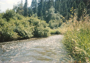
The Sanpoil River is a tributary of the Columbia River, in the U.S. state of Washington. The river is named for the Sanpoil, the Interior Salish people who live along the river course. The name is from the Okanagan term [snpʕʷílx], meaning "people of the gray country", or "gray as far as one can see".

The U.S. state of Washington is home to a number of public and private ferry systems, most notably the state-run Washington State Ferries.
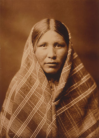
The Sanpoil are a Native American people of the U.S. state of Washington. They are one of the Salish peoples and are one of the twelve members of the Confederated Tribes of the Colville Reservation.
The Nespelem people belong to one of twelve aboriginal Confederated Tribes of the Colville Indian Reservation in eastern Washington. They lived primarily near the banks of the Nespelem River, an Upper Columbia River tributary, in an area now known as Nespelem, Washington, located on the Colville Indian Reservation. Alternate spellings include Nespelim or Nespilim.

U.S. Route 2 (US 2) is a component of the United States Numbered Highway System that connects the city of Everett in the U.S. state of Washington to the Upper Peninsula of Michigan, with a separate segment that runs from Rouses Point, New York, to Houlton, Maine. Within Washington, the highway travels on a 326-mile-long (525 km) route that connects the western and eastern regions of the state as a part of the state highway system and the National Highway System. US 2 forms parts of two National Scenic Byways, the Stevens Pass Greenway from Monroe to Cashmere and the Coulee Corridor Scenic Byway near Coulee City, and an All-American Road named the International Selkirk Loop within Newport.
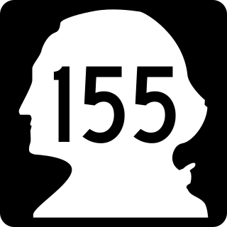
State Route 155 is a state highway in the U.S. state of Washington, running from U.S. Route 2 near Coulee City over Disautel Pass to U.S. Route 97 and State Route 20 in the city of Omak. It is the main north–south route through the area around Grand Coulee Dam.

State Route 305 (SR 305) is a 13.50-mile-long (21.73 km) state highway in the U.S. state of Washington, primarily serving Bainbridge Island in Kitsap County and connecting it to Seattle in King County via the Seattle–Bainbridge Island ferry. The highway travels north through Bainbridge Island and leaves the island on the Agate Pass Bridge into the Kitsap Peninsula. SR 305 continues northwest through Poulsbo, intersecting SR 307 and ending at the SR 3 freeway. The highway was created during the 1964 highway renumbering and was preceded by Secondary State Highway 21A (SSH 21A), established in 1937. The ferry, part of the highway since 1994, is served by the Jumbo Mark-II-classMV Tacoma and MV Wenatchee and operates on a 35-minute crossing time.

U.S. Route 395 (US 395) is a United States Numbered Highway that runs from California to the inland regions of Oregon and Washington. It travels north–south through Washington, including long concurrencies with Interstate 82 (I-82) and I-90, and connects the Tri-Cities region to Spokane and the Canadian border at Laurier.

U.S. Route 97 in the U.S. state of Washington is a 322-mile (518 km) route which traverses from the Oregon state line at the northern end of the Sam Hill Memorial Bridge in Maryhill, north to the Canada–US border in Okanogan County near Oroville. The highway serves major cities such as Goldendale, Yakima, Ellensburg and Wenatchee before continuing towards the Alaska Highway at the Yukon border as British Columbia Highway 97. Along the length of the roadway, US 97 is concurrent with State Route 14 in Maryhill, Interstate 82 (I-82) and US 12 between Union Gap and Ellensburg, I-90 briefly in Ellensburg, US 2 between Peshastin and rural Douglas County and SR 20 near Omak. An alternate route connects the highway with Chelan.

The Swawilla Fire is a large actively burning wildfire in Ferry and Okanogan counties, located in the U.S. state of Washington. The fire has been burning since July 17, 2024, and is currently 80% contained. It is the sixth fire to burn more than 1,000 acres as part of the 2024 Washington wildfire season, and is the largest fire of the entire season, at 53,343 acres covered as of August 3.

