Plymouth, Washington | |
|---|---|
 Plymouth, Washington with Columbia River in background. | |
 Plymouth, Washington | |
| Coordinates: 45°56′04″N119°21′01″W / 45.93444°N 119.35028°W | |
| Country | United States |
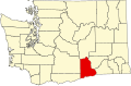
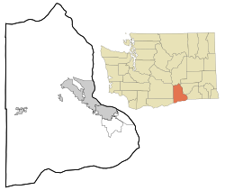
| State | Washington |
| County | Benton |
| Elevation | 292 ft (89 m) |
| Time zone | UTC-8 (Pacific (PST)) |
| • Summer (DST) | UTC-7 (PDT) |
| ZIP code | 99346 [2] |
| Area code | 509 |
| GNIS feature ID | 1507501 [1] |
Plymouth is an unincorporated community in Benton County, Washington, United States. Plymouth is located on the Columbia River across from Umatilla, Oregon. It is south of the Tri-Cities and is served by Interstate 82. It was named by early settlers who felt a nearby rock promontory resembled Plymouth Rock. [3]
 Plymouth, Washington as seen from the Oregon side of the Columbia River at the mouth of the Umatilla River.
 Plymouth, Washington post office as seen in July 2013.