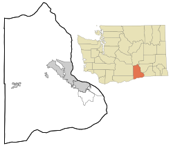
Longview, Benton County, Washington

Last updated
Longview, Washington
Benton County Washington Incorporated and Unincorporated areas.svg
Red pog.svg
Longview, Washington
Location of Longview, Washington
Coordinates: 45°55′44″N119°24′48″W / 45.9290217°N 119.4133536°W / 45.9290217; -119.4133536 Coordinates: 45°55′44″N119°24′48″W / 45.9290217°N 119.4133536°W / 45.9290217; -119.4133536 [1]
Country United States
State Washington
County Benton
Elevation
[2]
302 ft (92 m)
Time zone UTC-8 (Pacific (PST))
  Summer (DST) UTC-7 (PDT)
ZIP code
99346
Area code(s) 509
GNIS feature ID1514878 [2]

Longview is an unincorporated historic community in Benton County, Washington, United States, located approximately three miles west of Umatilla, Oregon on the north bank of the Columbia River, just above Devil's Bend Rapids. [3]

This community was known as King, for David and America King who homesteaded here, from 1904 until the Spokane, Portland and Seattle Railway established a construction camp in 1906 called Gravel because of the abundance of gravel found in the area. At the completion of the railroad construction, the SP&S established a station that went through several name changes; first Francis in 1908, then Tuton in 1909, and Longview in 1911. Francis was rejected because Washington already had a Frances, Tuton was often confused with the nearby town of Luzon, and so the name became Longview, because of the "long" view of the Columbia River from the community's location. [4] [5]

In October 1922, the developers of Longview in Cowlitz County, Washington petitioned the residences of Longview, Benton County to change the station name, freeing the name for their development in Cowlitz County. In exchange for a covered platform on which to drop the mail in a protected location, the residence agreed and the railroad chose the name Barger. Finally, on November 23, 1943, the station was renamed the original King until it closed in 1951. [3] [5]

Related Research Articles

Kalama, Washington City in Washington, United States

Kalama is a city in Cowlitz County, Washington, United States. It is part of the Longview, Washington Metropolitan Statistical Area. The population was 2,344, according to the 2010 census.

Kelso, Washington City in Washington, United States

Kelso is a city in the southwestern part of the U.S. state of Washington and is the county seat of Cowlitz County. At the 2010 census, the population was 11,925. Kelso is part of the Longview, Washington Metropolitan Statistical Area, which has a population of 102,410. Kelso shares its long western border with Longview. It is near Mount St. Helens.

Longview, Washington City in Washington, United States

Longview is a city in Cowlitz County, Washington, United States. It is the principal city of the Longview, Washington Metropolitan Statistical Area, which encompasses all of Cowlitz County. Longview's population was 36,648 at the time of the 2010 census, making it the largest city in Cowlitz County. The city is located in southwestern Washington, at the junction of the Cowlitz and Columbia rivers. Longview shares a border with Kelso to the east, which is the county seat.

Cowlitz River river in the United States of America

The Cowlitz River is a river in the state of Washington in the United States, a tributary of the Columbia River. Its tributaries drain a large region including the slopes of Mount Rainier, Mount Adams, and Mount St. Helens.

Hanford, Washington Unincorporated community in Washington, United States

Hanford was a small agricultural community in Benton County, Washington, United States. It was depopulated in 1943 along with the town of White Bluffs in order to make room for the nuclear production facility known as the Hanford Site. The town was located in what is now the "100F" sector of the site.

State Route 4 (SR 4) is a 62.27-mile-long (100.21 km) state highway, serving the southwestern region of the U.S. state of Washington. The highway, also known as the Ocean Beach Highway, travels east along the Columbia River from U.S. Route 101 (US 101) at Johnston's Landing through Pacific, Wahkiakum and Cowlitz counties to an interchange with Interstate 5 (I-5) in Kelso. SR 4 is designated as part of the Lewis and Clark Trail Scenic Byway, a state scenic byway, as well as part of the National Highway System. The highway, along with I-5 and SR 14, forms the former route of US 830, which ran along the Columbia River from Johnston's Landing to Maryhill from the creation of the United States Numbered Highways in 1926 until 1968. US 830 was co-signed with Primary State Highway 12 (PSH 12) from Johnston's Landing to Kelso and was created in 1937 as the successor to various unsigned state highways.

Washington State Route 506 Highway in Washington

State Route 506 (SR 506) is an 11.53-mile (18.56 km) long state highway in Cowlitz and Lewis counties, part of the U.S. state of Washington, serving the communities of Ryderwood and Vader. SR 506 begins at the intersection of 2nd and Morse Street in Ryderwood, a community in Cowlitz County, traveling north into Lewis County and turning east past Vader to parallel the Cowlitz River and interchange Interstate 5 (I-5) twice west of Toledo. Originating as Secondary State Highway 1P (SSH 1P) in 1937, the highway was designated in its current form in 1964 and it shared its eastern terminus with SR 505. SR 411 terminated at Vader and both SR 411 and SR 505 were moved away from SR 506 in 1991.

Washington State Route 432 highway in Washington

State Route 432 (SR 432) is a 10.32-mile-long (16.61 km) state highway in the U.S. state of Washington, serving the cities of Longview and Kelso in Cowlitz County. The highway travels east along the Columbia River from an intersection with SR 4 in West Longview through the Port of Longview and the termini of SR 433 and SR 411 in Longview. SR 432 crosses the Cowlitz River on a divided highway and ends at an interchange with Interstate 5 (I-5) in Kelso. SR 432 was established during the 1964 highway renumbering as SR 832, replacing a branch of Primary State Highway 12 (PSH 12) that had been routed through Longview and Kelso since 1937. SR 432 was established in 1968 and originally routed on Nichols Boulevard within Longview and was re-aligned onto its current route in 1991 after the opening of Industrial Way.

Port of Longview

The Port of Longview is a deep-water port authority located in Longview, on the Columbia River in southwest Washington, United States. It was established in 1921 by Washington state law, and operates as a unit of local government. The port is overseen by a locally elected, three-member board of commissioners. Each commissioner is elected for a six-year term and is directly responsible to the voters for port operations.

Washington State Route 411 highway in Washington

State Route 411 (SR 411) is a 13.48-mile (21.69 km) state highway located in Cowlitz County in the U.S. state of Washington, serving Longview, Kelso, West Side Highway and Castle Rock. The roadway, which parallels the Cowlitz River and Interstate 5 (I-5), begins at an interchange with SR 432 in Longview and travels north past a spur route, under SR 4 and across the Cowlitz River to become concurrent with I-5 Business and end at an interchange with I-5, I-5 Business and SR 504 in Castle Rock. The road first appeared on a map in 1951 and originally signed as Secondary State Highway 12H (SSH 12H) in 1957, SR 411 was established in 1964 and ran from Kelso to Vader. In 1991, the highway was extended south to SR 432 in Longview, the former route becoming SR 411 Spur, and was shortened to I-5 / I-5 Business / SR 504 in Castle Rock.

Mount Coffin

Mount Coffin was a promontory in what is now Longview, Cowlitz County, Washington, U.S.. It served as native burial grounds for the Skillute, a Chinook Jargon speaking tribe who practiced above-ground interment of their deceased. The memaloose illahee, or cemetery was named by Lieutenant William Robert Broughton of George Vancouver's expedition aboard HMS Chatham in 1792. The landmark was leveled for its gravel during construction of the Port of Longview.

Apricot, Washington Unincorporated community in Washington, United States

Apricot is an unincorporated community in Benton County, Washington, United States, located between Prosser and Grandview.

Whitstran, Washington Unincorporated community in Washington, United States

Whitstran is a small, unincorporated community in Benton County, Washington, located approximately four miles Northeast of Prosser and approximately ten miles west of Benton City. The focal point of the community is at the intersection of North Rothrock Road and Foisy Road, where there is a small grocery store, and nearby Whitstran Elementary School.

Byron, Washington Unincorporated community in Washington, United States

Byron is an unincorporated community in Yakima County, Washington, United States, located approximately three miles west of Prosser.

Gibbon, Washington Unincorporated community in Washington, United States

Gibbon is an unincorporated community in Benton County, Washington, United States, between Prosser and Benton City.

North McNary, Washington Unincorporated community in Washington, United States

North McNary is an unincorporated community in Benton County, Washington, United States, located immediately north of Umatilla, Oregon on the north bank of the Columbia River near McNary Dam.

North Prosser, Washington Unincorporated community in Washington, United States

North Prosser is an unincorporated community in Benton County, Washington, United States, located approximately one mile north of Prosser.

Vista, Washington neighborhood in Benton, Washington, United States

Vista is a neighborhood of Kennewick in Benton County, Washington, United States. It is located within the city limits of Kennewick.

Whitcomb, Washington Unincorporated community in Washington, United States

Whitcomb is an unincorporated community in Benton County, Washington, United States, located approximately 22 miles south of Prosser on the north bank of the Columbia River on the south side of Canoe Canyon.

Castle Rock, Morrow County, Oregon Historic unincorporated community in Oregon, United States

Castle Rock was a historic unincorporated community, post office, and railway station in Morrow County, Oregon, United States. They were named for a low bluff along the Columbia River that was said to look like a castle as seen from the river.

References

  1. "Longview (historical)". Geographic Names Information System . United States Geological Survey. March 1, 1993. Retrieved 2012-10-28.
  2. 1 2 "US Board on Geographic Names". United States Geological Survey. 2007-10-25. Retrieved 2008-01-31.
  3. 1 2 "Washington Place Names database". Tacoma Public Library. Archived from the original on September 5, 2012. Retrieved October 30, 2012.
  4. "Station Roster Master List: Longview". Northern Pacific Railway Historical Association. Retrieved October 30, 2012.
  5. 1 2 Davis, Jean Carol; Bergum, Vickie Silliman (1996). Benton County Place Names. Kennewick, WA: East Benton County Historical Society. pp. 3, 43, 47, 48.