Apricot, Washington

Last updated
Apricot, Washington

Apricot Spur
Benton County Washington Incorporated and Unincorporated areas.svg
Red pog.svg
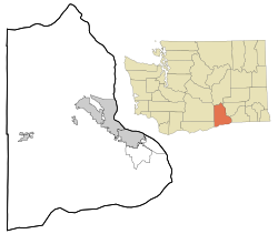
Apricot, Washington
Location of Apricot, Washington
Coordinates: 46°14′11″N119°51′27″W / 46.2365213°N 119.8575366°W / 46.2365213; -119.8575366 Coordinates: 46°14′11″N119°51′27″W / 46.2365213°N 119.8575366°W / 46.2365213; -119.8575366 [1]
Country United States
State Washington
County Benton
Elevation
[2]
823 ft (251 m)
Time zone UTC-8 (Pacific (PST))
  Summer (DST) UTC-7 (PDT)
ZIP code
99350
Area code(s) 509
GNIS feature ID1510784 [2]

Apricot is an unincorporated community in Benton County, Washington, United States, located between Prosser and Grandview.

Unincorporated area Region of land not governed by own local government

In law, an unincorporated area is a region of land that is not governed by a local municipal corporation; similarly an unincorporated community is a settlement that is not governed by its own local municipal corporation, but rather is administered as part of larger administrative divisions, such as a township, parish, borough, county, city, canton, state, province or country. Occasionally, municipalities dissolve or disincorporate, which may happen if they become fiscally insolvent, and services become the responsibility of a higher administration. Widespread unincorporated communities and areas are a distinguishing feature of the United States and Canada. In most other countries of the world, there are either no unincorporated areas at all, or these are very rare; typically remote, outlying, sparsely populated or uninhabited areas.

Benton County, Washington U.S. county in Washington, United States

Benton County is a county in the south-central portion of the U.S. state of Washington. As of the 2010 census, its population was 175,177. The county seat is Prosser, and its largest city is Kennewick. The Columbia River demarcates the county's north, south, and east boundaries.

Prosser, Washington City in Washington, United States

Prosser is a city in and the county seat of Benton County, Washington, United States, along the Yakima River with only one zip code 99350. The population was 5,714 at the 2010 census.

The community was established in 1916 and probably named Apricot "for the fine apricot land offered" by the land agent of the Yakima Irrigating and Improvement Company. The community was once a railroad siding for the Northern Pacific Railroad. [3] [4]

Related Research Articles

Donald, Washington Unincorporated community & census-designated place in Washington, United States

Donald is a census-designated place and unincorporated community in Yakima County, Washington, United States. The population was 91 at the 2010 census.

Sawyer, Washington Unincorporated community in Washington, United States

Sawyer is an unincorporated community in Yakima County, Washington, United States.

Ashue, Washington Unincorporated community in Washington, United States

Ashue is an unincorporated community in Yakima County, Washington, United States, located approximately two mile southwest of Wapato.

Farron, Washington Unincorporated community in Washington, United States

Farron is an unincorporated community in Yakima County, Washington, United States, located approximately five miles southwest of Wapato.

Flint, Washington Unincorporated community in Washington, United States

Flint is an unincorporated community in Yakima County, Washington, United States, located approximately three miles east of Wapato.

Holtzinger, Washington Unincorporated community in Washington, United States

Holtzinger is an unincorporated community in Yakima County, Washington, United States, located approximately five miles northwest of Yakima.

Midvale, Washington Unincorporated community in Washington, United States

Midvale is an unincorporated community in Yakima County, Washington, United States, located immediately south of Sunnyside.

Nass, Washington Unincorporated community in Washington, United States

Nass is an unincorporated community in Yakima County, Washington, United States, located approximately one mile east of Granger.

Lichty, Washington Unincorporated community in Washington, United States

Lichty is an unincorporated community in Yakima County, Washington, United States, located between Sunnyside and Grandview on U.S. Route 12.

Byron, Washington Unincorporated community in Washington, United States

Byron is an unincorporated community in Yakima County, Washington, United States, located approximately three miles west of Prosser.

Birchfield, Washington Unincorporated community in Washington, United States

Birchfield is an unincorporated community in Yakima County, Washington, United States, located between Terrace Heights and Moxee.

Pomona, Washington Unincorporated community in Washington, United States

Pomona is an unincorporated community in Yakima County, Washington, United States, located immediately northeast of Selah.

Weikel, Washington Unincorporated community in Washington, United States

Weikel is an unincorporated community in Yakima County, Washington, United States, located approximately one mile north of Yakima, adjacent to Cowiche Creek, at the west end of Cowiche Canyon.

Fruitvale, Washington Unincorporated community in Washington, United States

Fruitvale is an unincorporated community in Yakima County, Washington, United States, located within the north city limits of Yakima.

Badger, Washington Unincorporated community in Washington, United States

Badger is an unincorporated community in Benton County, Washington, United States, located approximately three miles southwest of Richland, near Badger Springs and Badger Canyon.

Berrian, Washington Unincorporated community in Washington, United States

Berrian is an unincorporated community in Benton County, Washington, United States, located approximately nine miles east of Umatilla, Oregon on the north bank of the Columbia River.

Chaffee, Washington Unincorporated community in Washington, United States

Chaffee is an unincorporated community in Benton County, Washington, United States, located approximately five miles west of Benton City on the north bank of the Yakima River.

Gibbon, Washington Unincorporated community in Washington, United States

Gibbon is an unincorporated community in Benton County, Washington, United States, between Prosser and Benton City.

North McNary, Washington Unincorporated community in Washington, United States

North McNary is an unincorporated community in Benton County, Washington, United States, located immediately north of Umatilla, Oregon on the north bank of the Columbia River near McNary Dam.

Vista, Washington neighborhood in Benton, Washington, United States

Vista is a neighborhood of Kennewick in Benton County, Washington, United States. It is located within the city limits of Kennewick.

References

  1. "Apricot". Geographic Names Information System . United States Geological Survey . Retrieved 2012-10-28.
  2. 1 2 "US Board on Geographic Names". United States Geological Survey. 2007-10-25. Retrieved 2008-01-31.
  3. "Washington Place Names database". Tacoma Public Library. Archived from the original on September 5, 2012. Retrieved October 31, 2012.
  4. "Station Roster Master List: Apricot". Northern Pacific Railway Historical Association. Retrieved October 31, 2012.