The Yakima River is a tributary of the Columbia River in south central and eastern Washington state, named for the indigenous Yakama people. Lewis and Clark mention in their journals that the Chin-nâm pam called the river Tâpe têtt, possibly from the French tape-tête, meaning "head hit". The length of the river from headwaters to mouth is 214 miles (344 km), with an average drop of 9.85 feet per mile (1.866 m/km). It is the longest river entirely in Washington state.
Benton County is a county in the south-central portion of the U.S. state of Washington. As of the 2020 census, its population was 206,873. The county seat is Prosser, and its largest city is Kennewick. The Columbia River demarcates the county's north, south, and east boundaries.

Kennewick is a city in Benton County in the U.S. state of Washington. It is located along the southwest bank of the Columbia River, just southeast of the confluence of the Columbia and Yakima rivers and across from the confluence of the Columbia and Snake rivers. It is the most populous of the three cities collectively referred to as the Tri-Cities. The population was 83,921 at the 2020 census.

Interstate 82 (I-82) is an Interstate Highway in the Pacific Northwest region of the United States that travels through parts of Washington and Oregon. It runs 144 miles (232 km) from its northwestern terminus at I-90 in Ellensburg, Washington, to its southeastern terminus at I-84 in Hermiston, Oregon. The highway passes through Yakima and the Tri-Cities, and is also part of the link between Seattle and Salt Lake City, Utah. I-82 travels concurrently with U.S. Route 97 (US 97) between Ellensburg and Union Gap; US 12 from Yakima to the Tri-Cities; and US 395 from Kennewick and Umatilla, Oregon.

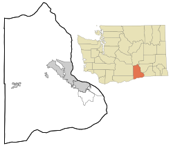
Benton City is a city in Benton County, Washington, United States. The population was 3,479 at the 2020 census. The city shares a school district with the adjacent unincorporated community of Kiona.
Prosser is a city in and the county seat of Benton County, Washington, United States. Situated along the Yakima River, it had a population of 6,062 at the 2020 census.

West Richland is a city in Benton County, Washington. The population was 16,295 at the time of the 2020 census. The city is part of the Tri-Cities metropolitan area, whose principal cities are Richland, Kennewick, and Pasco.

Roslyn is a city in Kittitas County, Washington, United States. The population was 893 at the 2010 census. Roslyn is located in the Cascade Mountains, about 80 miles east of Seattle. The town was founded in 1886 as a coal mining company town. During the 20th century, the town gradually transitioned away from coal, and today its economy is primarily based on forestry and tourism. The town was the filming location for The Runner Stumbles, Northern Exposure, and The Man in the High Castle. Many of the town's historical structures have been preserved, and its downtown was added to the National Register of Historic Places in 1978.

Thorp is an unincorporated community and census-designated place (CDP) in Kittitas County, Washington, United States. In 2015, the population was 317 according to statistics compiled by Data USA.

Central Washington is a region of the U.S. state of Washington between the western and eastern parts of the state extending from the border with the Canadian province of British Columbia in the north to the border with the U.S. state of Oregon in the south. Generally, the western edge is the Cascade Range and the eastern edge is in the vicinity of the 119th meridian west.

This is a list of properties and historic districts in Washington that are listed on the National Register of Historic Places. There are at least three listings in each of Washington's 39 counties.

State Route 240 (SR 240) is a state highway in the U.S. state of Washington. It travels diagonally from northwest to southwest within Benton County, serving the Hanford Nuclear Reservation and the Tri-Cities region. The highway begins at a junction with SR 24 and travels around Richland on a limited-access bypass. From there, it briefly overlaps Interstate 182 (I-182) and continues southeast as a freeway along the Columbia River into Kennewick, terminating at an interchange with U.S. Route 395 (US 395). SR 240 is one of the busiest highways in the Tri-Cities region, with a daily average of 76,000 vehicles on a section crossing the Yakima River Delta.
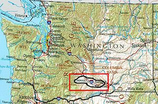
The Yakima Valley AVA was the first American Viticultural Area established within Washington state, gaining the recognition in 1983. Part of the larger Columbia Valley AVA, Yakima Valley AVA is home to more than 18,000 acres (73 km2) of vineyards, giving the area the largest concentration of wineries and vineyards in the state. The most widely planted varietals in the area are Chardonnay, Riesling, Merlot, Cabernet Sauvignon, Pinot gris, and Syrah. Nearly 40% of Washington state yearly wine production is made from Yakima Valley grapes. In addition to grapes, the Yakima Valley is also home to several fruit orchards growing apples, cherries, nectarines, peaches, pears and plums. Around the town of Zillah, there is the Zillah Fruit Loop driving tour through the area's orchards and vineyards. The area is also home to nearly 80% of the US hop production.

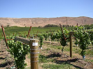
The Red Mountain AVA is an American Viticultural Area that includes the land surrounding Red Mountain in Benton County, Washington. It is part of the Yakima Valley AVA, which in turn is part of the larger Columbia Valley AVA. Located between Benton City and the City of West Richland, the Red Mountain AVA is the smallest in the state at only 4,040 acres (1,630 ha) in area. The area has more than 2,000 acres (810 ha) under cultivation of primarily red varietals including Cabernet Sauvignon, Merlot, Sangiovese, Cabernet Franc and Syrah. The reputation of the wines produced in this area has brought Red Mountain AVA worldwide acclaim. The vineyards in this appellation have produced grapes for some of the most sought after wines in Washington State.

State Route 224 (SR 224) is a 10.15-mile (16.33 km) long state highway located entirely in Benton County, Washington, United States. The highway serves to connect SR 225 to Interstate 82 (I-82) and U.S. Route 12 (US 12), and to link Benton City to West Richland and Richland. Before the 1964 state highway renumbering the highway was numbered Secondary State Highway 3R. SR 224 is a lightly traveled rural highway except through Richland, where an average of 16,000 cars traveled the highway daily in 2009. The Washington State Department of Transportation (WSDOT) rebuilt its southern terminus as a roundabout in 2016, as part of a project to improve traffic congestion near the Red Mountain AVA.

State Route 225 (SR 225) is an 11.32-mile (18.22 km) long two-lane state highway located entirely in Benton County, Washington, United States. The highway travels over the Benton City – Kiona Bridge, which is listed on the Washington Heritage Register and National Register of Historic Places, over the Yakima River. After turning through Benton City, the highway parallels the river for the remainder of the route. Several different proposals have been introduced to alleviate traffic flow issues at the SR 224 / SR 225 interchange, which was ultimately replaced with a roundabout in 2016.

Horn Rapids Dam is a concrete barrage dam on the Yakima River in Benton County, Washington near the intersection of SR 240 and SR 225. The dam is not used for hydroelectric production, rather to fill irrigation canals on either bank of the river.
The Rattlesnake Hills, also known as Rattlesnake Ridge, is a 16-mile (26 km) long anticline mountain ridge in Yakima County and Benton County in the U.S. state of Washington. It should not be confused with the much smaller Rattlesnake Ridge located near the west end of Ahtanum Ridge just south of Yakima, Washington and west of Union Gap, Washington. The highest point in the hills is the 3,629 feet (1,106 m) Lookout Summit, which surpasses the more well-known Rattlesnake Mountain by approximately 100 ft (30 m). The Rattlesnake Hills are part of the Yakima Fold Belt of east-tending long ridges formed by the folding of Miocene Columbia River basalt flows.

The Benton City – Kiona Bridge is a steel box girder and cable-stayed bridge carrying two lanes of Washington State Route 225 over the Yakima River in Benton City, Benton County, Washington. The current span was opened to traffic on July 4, 1957 and measures 400-foot-long (121.9 m) by 26-foot (7.8 m) wide. Two bridges had previously connected the cities of Benton City and Kiona before and were located 300 feet (91 m) downstream. The first bridge was open by 1901, and the immediate predecessor bridge was closed and torn down in 1964. The bridge is owned and maintained by the Washington State Department of Transportation, and was added to the Washington Heritage Register on January 25, 2002.

Whitstran is a small, unincorporated community in Benton County, Washington, located approximately four miles Northeast of Prosser and approximately ten miles west of Benton City. The focal point of the community is at the intersection of North Rothrock Road and Foisy Road, where there is a small grocery store, and nearby Whitstran Elementary School.