The Hanford Site is a decommissioned nuclear production complex operated by the United States federal government on the Columbia River in Benton County in the U.S. state of Washington. It has also been known as Site W and the Hanford Nuclear Reservation. Established in 1943 as part of the Manhattan Project, the site was home to the Hanford Engineer Works and B Reactor, the first full-scale plutonium production reactor in the world. Plutonium manufactured at the site was used in the first atomic bomb, which was tested in the Trinity nuclear test, and in the Fat Man bomb used in the bombing of Nagasaki.

The Tri-Cities are three closely linked cities at the confluence of the Yakima, Snake, and Columbia Rivers in the Columbia Basin of Eastern Washington. The cities border one another, making the Tri-Cities seem like one uninterrupted mid-sized city. The three cities function as the center of the Tri-Cities metropolitan area, which consists of Benton and Franklin counties. The Tri-Cities urban area includes the city of West Richland, the census-designated places (CDP) of West Pasco and Finley, as well as the CDP of Burbank, despite the latter being located in Walla Walla County.

Richland is a city in Benton County, Washington, United States. It is located in southeastern Washington at the confluence of the Yakima and the Columbia Rivers. As of the 2020 census, the city's population was 60,560. Along with the nearby cities of Pasco and Kennewick, Richland is one of the Tri-Cities, and is home to the Hanford nuclear site.
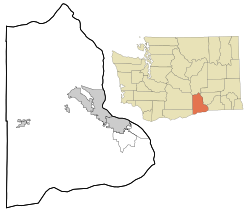
Benton County is a county in the south-central portion of the U.S. state of Washington. As of the 2020 census, its population was 206,873. The county seat is Prosser, and its most populous city is Kennewick. The Columbia River demarcates the county's north, south, and east boundaries.
Kennewick is a city in Benton County in the U.S. state of Washington. It is located along the southwest bank of the Columbia River, just southeast of the confluence of the Columbia and Yakima rivers and across from the confluence of the Columbia and Snake rivers. It is the most populous of the three cities collectively referred to as the Tri-Cities. The United States Census Bureau estimated the population to be 84,750 as of 2022, up from 83,921 at the 2020 United States Census.

Hanford was a small agricultural community in Benton County, Washington, United States. It and White Bluffs were depopulated in 1943 in order to make room for the nuclear production facility known as the Hanford Site. The town was located in what is now the "100F" sector of the site.

The B Reactor at the Hanford Site, near Richland, Washington, was the first large-scale nuclear reactor ever built. The project was a key part of the Manhattan Project, the United States nuclear weapons development program during World War II. Its purpose was to convert natural uranium metal into plutonium-239 by neutron activation, as plutonium is simpler to chemically separate from spent fuel assemblies, for use in nuclear weapons, than it is to isotopically enrich uranium into weapon-grade material. The B reactor was fueled with metallic natural uranium, graphite moderated, and water-cooled. It has been designated a U.S. National Historic Landmark since August 19, 2008 and in July 2011 the National Park Service recommended that the B Reactor be included in the Manhattan Project National Historical Park commemorating the Manhattan Project. Visitors can take a tour of the reactor by advance reservation.

The Hanford Reach National Monument is a national monument in the U.S. state of Washington. It was created in 2000, mostly from the former security buffer surrounding the Hanford Nuclear Reservation. The area has been untouched by development or agriculture since 1943. For this reason, it is considered an involuntary park.

State Route 240 (SR 240) is a state highway in the U.S. state of Washington. It travels diagonally from northwest to southwest within Benton County, serving the Hanford Nuclear Reservation and the Tri-Cities region. The highway begins at a junction with SR 24 and travels around Richland on a limited-access bypass. From there, it briefly overlaps Interstate 182 (I-182) and continues southeast as a freeway along the Columbia River into Kennewick, terminating at an interchange with U.S. Route 395 (US 395). SR 240 is one of the busiest highways in the Tri-Cities region, with a daily average of 76,000 vehicles on a section crossing the Yakima River Delta.
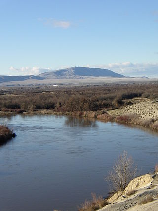
Rattlesnake Mountain is a 3,531 ft windswept treeless ridge overlooking the Hanford nuclear site. Parts of the western slope are privately owned ranchland, while the eastern slope is under the federal protection of the Arid Lands Ecology Reserve, a unit of the Hanford Reach National Monument, managed by the United States Fish and Wildlife Service. The mountain is the second highest point in Benton County, with its neighbor Lookout Summit surpassing it by only 98 ft.

Camp Columbia or Columbia Camp was a prison labor camp established on the north shore of the Yakima River opening on February 1, 1944 near Horn Rapids. The camp was operated between February 1944 and October 1947 by Federal Bureau of Prisons to provide labor supporting the Hanford Site. The camp was used to house "minimum-custody-type improvable male offenders," who had no more than one year to serve. These were violators of national defense, wartime and military laws. Included were conscientious objectors, violators of rationing and price support laws, those convicted of espionage, sabotage and sedition and those convicted by military courts martial. Aliens who failed to register were also in this category but none of them were sent here because the camp was located on the southern edge of the 670 square miles (1,740 km2) Hanford Site.
The Rattlesnake Hills, also known as Rattlesnake Ridge, is a 16-mile (26 km) long anticline mountain ridge in Yakima County and Benton County in the U.S. state of Washington. It should not be confused with the much smaller Rattlesnake Ridge located near the west end of Ahtanum Ridge just south of Yakima, Washington and west of Union Gap, Washington. The highest point in the hills is the 3,629 feet (1,106 m) Lookout Summit, which surpasses the more well-known Rattlesnake Mountain by approximately 100 ft (30 m). The Rattlesnake Hills are part of the Yakima Fold Belt of east-tending long ridges formed by the folding of Miocene Columbia River basalt flows.

The Gold Coast Historic District is a residential area in Richland, Washington, United States. The town that was built during the World War II Manhattan Project to house workers at the Hanford atomic plant. The homes within the district date from 1948–49 and are associated with the Cold War expansion of plutonium manufacturing at the plant.

Plume is a collection of poetry, written by Kathleen Flenniken. Published in 2012 by the University of Washington Press, the poetry presents a brief history of Richland, Washington and the Hanford Nuclear Reservation. The author examines the actions of the US Department of Energy regarding the establishment and operation of Hanford, a nuclear production facility and how their actions affected the health of individuals and families living and working in or near the Reservation. While the US government assured the employees and families who lived in the area that they were safe from exposure to radioactive materials, declassified documents revealed that early protective measures were inadequate, while people were dying of radiation-induced illness. The book was a finalist for both the William Carlos Williams Award from the Poetry Society of America and the Pacific Northwest Booksellers Association Award, while it was the recipient of the Washington State Book Award in 2013.
The 2016 Washington wildfires season were a series of wildfires in the U.S. state of Washington, notable because of brush fires near the Hanford Nuclear Reservation, and because of brush fires near Spokane, Washington.

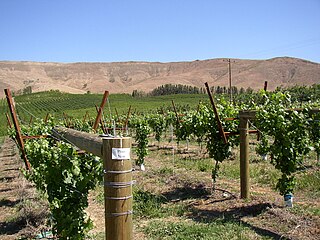
Wahluke Slope is a geographic feature in Grant, Benton and Adams Counties of Eastern Washington. It is a broad, south-facing slope with a grade of about 8%, situated between the Saddle Mountains and the Columbia River's Hanford Reach. It has been described as "basically a 13-mile-wide gravel bar" created by the Glacial Lake Missoula floods at the end of the last ice age about 15,000 years ago. Much of the Slope, part of the Hanford Nuclear Reservation, was added to the Saddle Mountain National Wildlife Refuge in 1999. Much of the remainder is used for viniculture.

Locke Island is an island located in the Hanford Reach of the Columbia River in Washington, United States. The island is protected as part of the Hanford Reach National Monument, which was created out of lands surrounding the Hanford Site. The island is an important archeological site and is on the National Register of Historic Places. These cultural resources are being threatened by erosion resulting from a landslide changing the river's course.
The following is a timeline of the history of the Tri-Cities, an area of the U.S. state of Washington encompassing the cities of Kennewick, Pasco, and Richland.
The Range 12 fire was started on July 30, 2016 in eastern Washington at the Yakima Training Center east of Yakima, Washington near Moxee, Washington. It quickly grew to over 176,000 acres (71,000 ha) to cover parts of Yakima County and Benton County. The fire was the third in recent years to affect the area surrounding the Hanford Reach National Monument and the Arid Lands Ecology Reserve near Rattlesnake Ridge. The fire was eventually contained through the use of controlled burns on Rattlesnake Mountain in Benton County due to concerns that the fire was getting too close to the Hanford Nuclear Reservation, which had recently been compared to the Fukushima nuclear disaster by Newsweek magazine earlier in 2016. A lawsuit was filed by ranchers in the area due to loss of property, but was dismissed due to questions of jurisdiction. Even though there were no findings from the Anderson v. United States of America case, the dismissal document from May 21, 2019, points to a cause for the fire:
The Army training unit continued to engage in live fire training exercises through the afternoon on July 30, 2016. At approximately 4:40 p.m., one of the Army training unit's soldier's fired a machine gun at a target using tracer rounds. SJF ¶ 74. One of the tracer rounds ricocheted from the target area and landed on some brush, which started a brush fire. Id. The fire spread beyond the YTC and onto Plaintiffs' rangeland properties, causing property damage to Plaintiffs' cattle businesses.

The Hanford Engineer Works (HEW) was a nuclear production complex in Benton County, Washington, established by the United States federal government in 1943 as part of the Manhattan Project during World War II. It built and operated the B Reactor, the first full-scale plutonium production reactor. Plutonium manufactured at the HEW was used in the atomic bomb detonated in the Trinity test in July 1945, and in the Fat Man bomb used in the atomic bombing of Nagasaki in August 1945. The plant continued producing plutonium for nuclear weapons until 1971. The HEW was commanded by Colonel Franklin T. Matthias until January 1946, and then by Colonel Frederick J. Clarke.