Yellepit, Washington

Last updated
Yellepit, Washington
Benton County Washington Incorporated and Unincorporated areas.svg
Red pog.svg
Yellepit, Washington
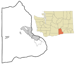
Location of Yellepit, Washington
Coordinates: 46°03′39″N118°57′05″W / 46.0609672°N 118.9513912°W / 46.0609672; -118.9513912 Coordinates: 46°03′39″N118°57′05″W / 46.0609672°N 118.9513912°W / 46.0609672; -118.9513912 [1]
Country United States
State Washington
County Benton
Elevation
[2]
341 ft (104 m)
Time zone UTC-8 (Pacific (PST))
  Summer (DST) UTC-7 (PDT)
ZIP code
99337
Area code(s) 509
GNIS feature ID1511443 [2]

Yellepit was an unincorporated community in Benton County, Washington, United States, located approximately three miles southwest of Wallula on the west bank of the Columbia River.
Contents

History

The community was named Yellepit in honor of a chief of the Walla Walla tribe who was encountered by the Lewis and Clark Expedition. [3] The community once had a large train depot, water tank and other buildings. In 1953 the community site was inundated by the waters of Lake Wallula. [4]

Related Research Articles

Umatilla, Oregon City in Oregon, United States

Umatilla is a city in Umatilla County, Oregon, United States. The population in 2010 was 6,906, but the city's population includes approximately 2,000 inmates incarcerated at Two Rivers Correctional Institution. Umatilla is also home to the only two strip clubs in Eastern Oregon; one of which is owned by the town's former Mayor.

Burbank, Washington CDP in Washington, United States

Burbank is a census-designated place (CDP) in Walla Walla County, Washington, United States, where the Snake River meets the Columbia. The population was 3,291 at the 2010 census. Named for Luther Burbank, the city is located just east of Pasco and Kennewick, across the Snake and Columbia Rivers, respectively. Burbank is part of the Tri-Cities, WA urban area, despite being located in the Walla Walla metropolitan area.

Touchet, Washington CDP in Washington, United States

Touchet is a census-designated place (CDP) in Walla Walla County, Washington, United States. The population was 421 at the 2010 census.

Wallula, Washington CDP in Washington, United States

Wallula is a census-designated place (CDP) in Walla Walla County, Washington, United States. The population was 179 at the 2010 census.

Walla Walla people

Walla Walla, sometimes Waluulapam, are a Sahaptin indigenous people of the Northwest Plateau. The duplication in their name expresses the diminutive form. The name Walla Walla is translated several ways but most often as "many waters."

Walla Walla River

The Walla Walla River is a tributary of the Columbia River, joining the Columbia just above Wallula Gap in southeastern Washington in the United States. The river flows through Umatilla County, Oregon, and Walla Walla County, Washington. Its drainage basin is 1,758 square miles (4,550 km2) in area.

U.S. Route 730 (US 730) is an east–west United States Highway, of which all but 6.08 miles of its 41.78 miles are within the state of Oregon. The highway starts in rural Morrow County in Eastern Oregon at an interchange with Interstate 84 (I-84) and US 30, located east of the city of Boardman. US 730 travels east along the Columbia River as a continuation of Columbia River Highway No. 2 into Umatilla County, intersecting I-82 and US 395 in the city of Umatilla. US 730 and US 395 form a short concurrency within the city before the highways part, with US 730 continuing northeast into Washington. The highway travels through rural Walla Walla County and ends at an intersection with US 12 south of Wallula.

Wallula Gap A large water gap of the Columbia River through basalt anticlines in the U.S. state of Washington

Wallula Gap is a large water gap of the Columbia River through the Horse Heaven Hills basalt anticlines in the Columbia River Basin in the U.S. state of Washington, just south of the confluence of the Walla Walla and Columbia rivers. It has been recognized as a National Natural Landmark by the National Park Service as a site that provides an important illustration of the geological history of the United States.

Lake Lewis

Lake Lewis was a temporary lake in the Pacific Northwest region of North America, largely formed by the Missoula Floods in about the 14th millennium B.C.

Horse Heaven Hills

The Horse Heaven Hills are a long range of high, rolling hills in Klickitat, Yakima, and Benton counties in Washington. The hills are an anticline ridge in the Yakima Fold Belt formed by north–south compression of lava flows in the Columbia River Basalt Group. The highest point is Bickleton Ridge in the west end of the hills. They lie within the rain shadow to the east of the Cascade Range, making them significantly drier and hotter than regions west of the Cascades.

Washington State Route 127

State Route 127 (SR 127) is a 27.05-mile-long (43.53 km) state highway serving the eastern region of the U.S. state of Washington. The highway, listed on the National Highway System, begins in rural Garfield County at U.S. Route 12 (US 12) and travels north across the Snake River on the Elmer Huntley Bridge. The roadway continues into Whitman County before it ends at SR 26 in Dusty. SR 127 formed a section of the Inland Empire Highway and Primary State Highway 3 (PSH 3) prior to becoming US 295 in 1926. US 295 was decommissioned in 1968 and replaced by a longer SR 127, traveling its full length from Dodge to Colfax from its establishment in 1970 until an extension of SR 26 to Colfax in 1979.

Rattlesnake Mountain (Benton County, Washington)

Rattlesnake Mountain is a 3,531 ft windswept treeless sub-alpine ridge overlooking the Hanford nuclear site. Parts of the western slope are privately owned ranchland, while the eastern slope is under the federal protection of the Arid Lands Ecology Reserve, a unit of the Hanford Reach National Monument, managed by the United States Fish and Wildlife Service. The mountain is the second highest point in Benton County, with its neighbor Lookout Summit surpassing it by only 98 ft.

Nile, Washington Unincorporated community & census-designated place in Washington, United States

Nile is a census-designated place and unincorporated community in Yakima County, Washington, United States, located approximately 35 miles northwest of Yakima in the Nile Valley adjacent to the Naches River in the Nile Valley, near the mouth of Rattlesnake Creek.

Rimrock, Washington Unincorporated community in Washington, United States

Rimrock is an unincorporated community in Yakima County, Washington, United States, located approximately 22 miles west of Yakima on the Tieton River, adjacent to Rimrock Lake.

Berrian, Washington Unincorporated community in Washington, United States

Berrian was an unincorporated community in Benton County, Washington, United States, located approximately nine miles east of Umatilla, Oregon on the north bank of the Columbia River.

Chaffee, Washington Unincorporated community in Washington, United States

Chaffee is an unincorporated community in Benton County, Washington, United States, located approximately five miles west of Benton City on the north bank of the Yakima River.

Longview, Benton County, Washington Unincorporated community in Washington, United States

Longview is an unincorporated historic community in Benton County, Washington, United States, located approximately three miles west of Umatilla, Oregon on the north bank of the Columbia River, just above Devil's Bend Rapids.

North McNary, Washington Unincorporated community in Washington, United States

North McNary is an unincorporated community in Benton County, Washington, United States, located immediately north of Umatilla, Oregon on the north bank of the Columbia River near McNary Dam.

Whitcomb, Washington Unincorporated community in Washington, United States

Whitcomb is an unincorporated community in Benton County, Washington, United States, located approximately 22 miles south of Prosser on the north bank of the Columbia River on the south side of Canoe Canyon.

References

  1. "Yellepit". Geographic Names Information System . United States Geological Survey . Retrieved 2012-10-28.
  2. 1 2 "US Board on Geographic Names". United States Geological Survey. 2007-10-25. Retrieved 2008-01-31.
  3. "Station Roster Master List: Yellepit". Northern Pacific Railway Historical Association. Retrieved October 30, 2012.
  4. "Washington Place Names database". Tacoma Public Library. Retrieved October 30, 2012.