
Multnomah Falls is a waterfall located on Multnomah Creek in the Columbia River Gorge, east of Troutdale, between Corbett and Dodson, Oregon, United States. The waterfall is accessible from the Historic Columbia River Highway and Interstate 84. Spanning two tiers on basalt cliffs, it is the tallest waterfall in the state of Oregon at 620 ft (189 m) in height. The Multnomah Creek Bridge, built in 1914, crosses below the falls, and is listed on the National Register of Historic Places.

The Fremont Bridge is a steel tied-arch bridge over the Willamette River located in Portland, Oregon, United States. It carries Interstate 405 and US 30 traffic between downtown and North Portland where it intersects with Interstate 5. It has the longest main span of any bridge in Oregon and is the second longest tied-arch bridge in the world. The bridge was designed by Parsons, Brinckerhoff, Quade and Douglas, and built by Murphy Pacific Corporation. In 2006, Sharon Wood Wortman published the third and latest version of The Portland Bridge Book. This book provides even more detail about the Fremont Bridge than covered here.
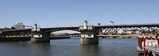
The Burnside Bridge is a 1926-built bascule bridge that spans the Willamette River in Portland, Oregon, United States, carrying Burnside Street. It is the second bridge at the same site to carry that name. It was added to the National Register of Historic Places in November 2012.

The Interstate Bridge is a pair of nearly identical steel vertical-lift, Parker through-truss bridges that carry Interstate 5 traffic over the Columbia River between Vancouver, Washington and Portland, Oregon in the United States.

The Sellwood Bridge is a deck arch bridge that spans the Willamette River in Portland, Oregon, in the United States. The current bridge opened in 2016 and replaced a 1925 span that had carried the same name. The original bridge was Portland's first fixed-span bridge and, being the only river crossing for miles in each direction, the busiest two-lane bridge in Oregon.

Forest Park is a public municipal park in the Tualatin Mountains west of downtown Portland, Oregon, United States. Stretching for more than 8 miles (13 km) on hillsides overlooking the Willamette River, it is one of the country's largest urban forest reserves. The park, a major component of a regional system of parks and trails, covers more than 5,100 acres (2,064 ha) of mostly second-growth forest with a few patches of old growth. More than 80 miles (130 km) of recreational trails, including the Wildwood Trail segment of the city's 40-Mile Loop system, crisscross the park.

Interstate 205 (I-205) is an auxiliary Interstate Highway in the Portland metropolitan area of Oregon and Washington, United States. The north–south freeway serves as a bypass route of I-5 along the east side of Portland, Oregon, and Vancouver, Washington. It intersects several major highways and serves Portland International Airport.

Interstate 405 (I-405), also known as the Stadium Freeway No. 61, is a short north–south Interstate Highway in Portland, Oregon. It forms a loop that travels around the west side of Downtown Portland, between two junctions with I-5 on the Willamette River near the Marquam Bridge to the south and Fremont Bridge to the north.

Downtown Portland is the central business district of Portland, Oregon, United States. It is on the west bank of the Willamette River in the northeastern corner of the southwest section of the city and where most of the city's high-rise buildings are found.
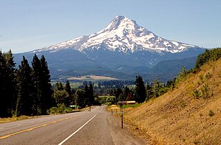
The Mount Hood Highway No. 26 is the Oregon Department of Transportation's designation for a 96.74-mile-long (155.69 km) highway from Portland east around the south side of Mount Hood and north via Bennett Pass to Hood River. It is marked as U.S. Route 26 from Portland to near Mount Hood and Oregon Route 35 the rest of the way to Hood River.

Washington Park is a public urban park in Portland in the U.S. state of Oregon. It includes a zoo, forestry museum, arboretum, rose garden, Japanese garden, amphitheatre, memorials, archery range, tennis courts, soccer field, picnic areas, playgrounds, public art and many acres of wild forest with miles of trails.

Interstate 5 (I-5) in the U.S. state of Oregon is a major Interstate Highway that traverses the state from north to south. It travels to the west of the Cascade Mountains, connecting Portland to Salem, Eugene, Medford, and other major cities in the Willamette Valley and across the northern Siskiyou Mountains. The highway runs 308 miles (496 km) from the California state line near Ashland to the Washington state line in northern Portland, forming the central part of Interstate 5's route between Mexico and Canada.

Interstate 84 (I-84) in the U.S. state of Oregon is a major Interstate Highway that traverses the state from west to east. It is concurrent with U.S. Route 30 (US 30) for most of its length and runs 376 miles (605 km) from an interchange with I-5 in Portland to the Idaho state line near Ontario. The highway roughly follows the Columbia River and historic Oregon Trail in northeastern Oregon, and is designated as part of Columbia River Highway No. 2 and all of the Old Oregon Trail Highway No. 6; the entire length is also designated as the Vietnam Veterans Memorial Highway. I-84 intersects several of the state's main north–south roads, including US 97, US 197, I-82, and US 395.

The Burnside Skatepark is a DIY concrete skatepark located in Portland, Oregon, United States. Burnside was the first DIY skatepark project. It is located under the east end of the Burnside Bridge. The project was started without permission from the city of Portland before being accepted as a public skatepark. Its features include many hips, pools, pyramids, and vertical sections. The skatepark receives no funding from the city of Portland. The park is regarded as an on-going project that is funded by donations.
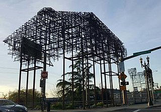
Inversion: Plus Minus is a pair of outdoor sculptures designed by artists and architects Annie Han and Daniel Mihalyo, located in southeast Portland, Oregon. The sculptures, constructed from weathered steel angle iron, are sited near the Morrison Bridge and Hawthorne Bridge along Southeast Grand Avenue and represent "ghosts" of former buildings. The installation on Belmont Street emphasizes "negative space" while the sculpture on Hawthorne Street appears as a more solid matrix of metal. According to the artists, the works are reminiscent of industrial buildings that existed on the project sites historically. Inversion was funded by the two percent for art ordinance as part of the expansion of the Eastside Portland Streetcar line and is managed by the Regional Arts & Culture Council.

The Black Suspension Bridge spans the Colorado River in the inner canyon of Grand Canyon National Park. The span length is 440 feet (130 m). The bridge is part of the South Kaibab Trail and is the river crossing used by mules going to Phantom Ranch. The Black Bridge and Silver Bridge, located about 700 metres (2,300 ft) downstream, are the only spans in hundreds of river miles.

Ned Flanders Crossing is a bicycle and pedestrian bridge spanning Interstate 405 to connect Portland, Oregon's Northwest District and Pearl District, in the United States. In 2019, the project's estimated cost was $6 million. It opened in June 2021 and was originally named Flanders Crossing, as it linked the two parts of Flanders Street separated by the interstate, before being re-dedicated to honor The Simpsons character Ned Flanders.
Human Access Project (HAP) is an organization based in Portland, Oregon, whose mission is "transforming Portland's relationship with the Willamette River". The organization's vision is a city in love with its river. HAP was founded by Willie Levenson, whose official title is the organization's Ringleader, is a tireless and effective advocate for swimming in the Willamette River he brings his love of water to his work as an activist for recreational access to the Willamette River in Portland.

