Lusted Road Bridge

Last updated
Lusted Road Bridge
Lusted Road Bridge, Sandy River (4708135135).jpg
Coordinates 45°26′42″N122°15′13″W / 45.44493°N 122.25364°W / 45.44493; -122.25364 Coordinates: 45°26′42″N122°15′13″W / 45.44493°N 122.25364°W / 45.44493; -122.25364
CarriesLusted Road
Crosses Sandy River
Locale Sandy, Oregon, U.S.
Owner Oregon Department of Transportation
Characteristics
Design Pennsylvania truss
MaterialIron
Total length300 feet (91 m) [1] [2]
Width34 feet (10 m) [2]
History
Construction end1894

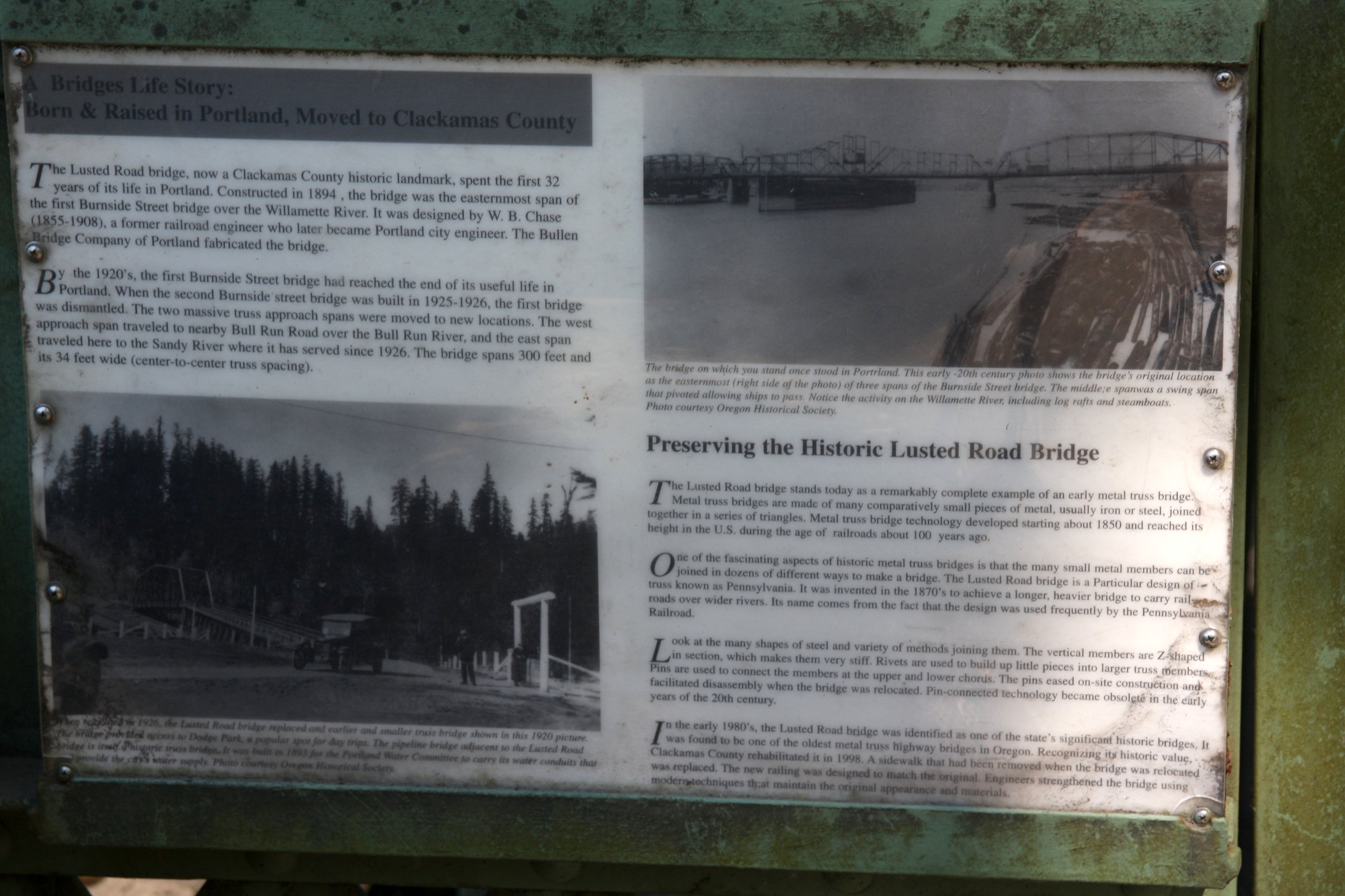
The Lusted Road Bridge, formerly known as the Portland Water Works Bridge, is an iron truss bridge that spans the Sandy River in Sandy, Clackamas County, Oregon, United States. Constructed for the Portland Water Works in 1894, the bridge was originally located in Portland and spanned the Willamette River.

Contents

History

Constructed for the Portland Water Works in 1894, the Lusted Road Bridge was designed by W. B. Chase of Portland, a railroad engineer. [2] It was fabricated by the Bullen Bridge Company. [2] Originally constructed in Portland and spanning the Willamette River, the bridge was known as the Portland Water Works Bridge. [2]

In 1926, after the completion of the Burnside Bridge, the bridge was dismantled and relocated. [2] The west approach of the bridge was located to Bull Run, where it spans the Bull Run River, while its east portion was relocated to its current location in Sandy, where it replaced a pre-existing truss bridge that provided access to Dodge Park. [2]

In the 1980s, the bridge was recognized as one of the state's significant historic bridges, and in 1998, it was rehabilitated by Clackamas County. [2]

Related Research Articles

Willamette River major river in northwest Oregon

The Willamette River is a major tributary of the Columbia River, accounting for 12 to 15 percent of the Columbia's flow. The Willamette's main stem is 187 miles (301 km) long, lying entirely in northwestern Oregon in the United States. Flowing northward between the Oregon Coast Range and the Cascade Range, the river and its tributaries form the Willamette Valley, a basin that contains two-thirds of Oregon's population, including the state capital, Salem, and the state's largest city, Portland, which surrounds the Willamette's mouth at the Columbia.

Wilsonville, Oregon City in Oregon, United States

Wilsonville is a city primarily in Clackamas County, Oregon, United States. A portion of the northern section of the city is in Washington County. It was founded as Boones Landing because of the Boones Ferry which crossed the Willamette River at the location; the community became Wilsonville in 1880. The city was incorporated in 1969 with a population of approximately 1,000. The population was 13,991 at the 2000 census, and grew to 19,509 as of 2010. Slightly more than 90% of residents at the 2000 census were white, with Hispanics comprising the largest minority group.

Portland General Electric

Portland General Electric (PGE) is a Fortune 1000 public utility based in Portland, Oregon. It distributes electricity to customers in parts of Multnomah, Clackamas, Marion, Yamhill, Washington, and Polk counties - 44% of the inhabitants of Oregon. Founded in 1888 as the Willamette Falls Electric Company, the company has been an independent company for most of its existence, though was briefly owned by the Houston-based Enron Corporation from 1997 until 2006 when Enron divested itself of PGE during its bankruptcy.

Molalla River river in the United States of America

The Molalla River is a 51-mile (82 km) tributary of the Willamette River in the northwestern part of Oregon in the United States. Flowing northwest from the Cascade Range through Table Rock Wilderness, it passes the city of Molalla before entering the larger river near Canby. The Molalla is the largest Willamette tributary unblocked by a dam.

Sandy River (Oregon) tributary of the Columbia River in northwestern Oregon in the United States

The Sandy River is a 56-mile (90 km) tributary of the Columbia River in northwestern Oregon in the United States. The Sandy joins the Columbia about 14 miles (23 km) upstream of Portland.

Ross Island Bridge

The Ross Island Bridge is a cantilever truss bridge that spans the Willamette River in Portland, Oregon. It carries U.S. Route 26 across the river between southwest and southeast Portland. The bridge opened in 1926 and was designed by Gustav Lindenthal and honors Oregon pioneer Sherry Ross. It is named for its proximity to Ross Island. Although it looks like a deck arch bridge, it is a cantilever deck truss bridge, a rare type in Oregon.

Sellwood Bridge bridge in United States of America

The Sellwood Bridge is a deck arch bridge that spans the Willamette River in Portland, Oregon, in the United States. The current bridge opened in 2016 and replaced a 1925 span that had carried the same name. The original bridge was Portland's first fixed-span bridge and, being the only river crossing for miles in each direction, the busiest two-lane bridge in Oregon. The Sellwood Bridge links the Sellwood and Westmoreland neighborhoods of Portland on the east side with Oregon Route 43/Macadam Avenue on the west side. At its east end it leads to Tacoma Street. The bridge is owned and operated by Multnomah County. The original span of 1925 was a steel truss bridge, while its 2016 replacement is a deck-arch-type bridge.

Abernethy Bridge bridge in United States of America

The George Abernethy Bridge, or simply Abernethy Bridge, is a steel plate and box girder bridge that spans the Willamette River between Oregon City and West Linn, Oregon, United States, and which carries Interstate 205. It is also known as the Oregon City Freeway Bridge and the I-205 Bridge.

Oregon Route 212 Highway in Oregon

Oregon Route 212 is an Oregon state highway that serves the eastern Portland metro area. It is an east–west route, running between Boring and Clackamas.

Oregon Route 43 Highway in Oregon

Oregon Route 43 is an Oregon state highway that runs between the cities of Oregon City and Portland, mostly along the western flank of the Willamette River. While it is technically known by the Oregon Department of Transportation as the Oswego Highway No. 3, on maps it is referred to by its route number or by the various street names it has been given.

Bull Run River (Oregon) tributary of the Sandy River in the U.S. state of Oregon

The Bull Run River is a 21.9-mile (35.2 km) tributary of the Sandy River in the U.S. state of Oregon. Beginning at the lower end of Bull Run Lake in the Cascade Range, it flows generally west through the Bull Run Watershed Management Unit (BRWMU), a restricted area meant to protect the river and its tributaries from contamination. The river, impounded by two artificial storage reservoirs as well as the lake, is the primary source of drinking water for the city of Portland, Oregon.

National Register of Historic Places listings in Oregon Wikimedia list article

This is a list of properties and historic districts in Oregon that are listed on the National Register of Historic Places. There are listings in all of Oregon's 36 counties.

Carver, Oregon Unincorporated community in Oregon, United States

Carver is an unincorporated community in Clackamas County, Oregon, United States, which, between 2004 and 2016, was part of the city of Damascus, Oregon. Before 2004, when the city of Damascus incorporated, Carver was an independent, unincorporated community. The city of Damascus disincorporated in 2016 returning Carver to its previous status.

Johnson Creek (Willamette River) Willamette River tributary in Oregon

Johnson Creek is a 25-mile (40 km) tributary of the Willamette River in the Portland metropolitan area of the U.S. state of Oregon. Part of the drainage basin of the Columbia River, its catchment consists of 54 square miles (140 km2) of mostly urban land occupied by about 180,000 people as of 2012. Passing through the cities of Gresham, Portland, and Milwaukie, the creek flows generally west from the foothills of the Cascade Range through sediments deposited by glacial floods on a substrate of basalt. Though polluted, it is free-flowing along its main stem and provides habitat for salmon and other migrating fish.

Steamboats of the Willamette River

The Willamette River flows northwards down the Willamette Valley until it meets the Columbia River at a point 101 miles from the Pacific Ocean, in the U.S. state of Oregon.

Sauvie Island Bridge

The Sauvie Island Bridge crosses the Multnomah Channel of the Willamette River near Portland, Oregon, United States. The original Parker truss bridge, built in 1950 with a 200-foot (61 m) main span, was replaced with a tied arch bridge with a 360-foot (110 m) span in 2008 due to cracks discovered in 2001.

Van Buren Street Bridge

The Van Buren Street Bridge is a swing span, steel motor vehicle bridge spanning the Willamette River at Corvallis in the U.S. state of Oregon. Opened in 1913, the black colored bridge was the first bridge across the river at Corvallis and is now the third oldest bridge across the river. Owned by the state and maintained by the Oregon Department of Transportation (ODOT), the 708-foot (216 m) long span is of a through truss design and carries one lane of traffic of Oregon Route 34 eastbound from Corvallis into neighboring Linn County. The bridge no longer is able to swing open.

Fir Creek (Bull Run River) river in the United States of America

Fir Creek is a tributary, about 5 miles (8 km) long, of the Bull Run River in the U.S. state of Oregon. Part of the system that provides drinking water to the city of Portland, it flows generally northwest through a protected part of the Mount Hood National Forest in Clackamas and Multnomah counties. It joins the Bull Run River at the upper end of Bull Run Reservoir 1, about 14 miles (23 km) from the larger stream's confluence with the Sandy River.

Course of the Willamette River

The Willamette River is a 187-mile (301 km) tributary of the Columbia River in the U.S. state of Oregon. The upper tributaries of the Willamette originate in mountains south and southeast of the twin cities of Eugene and Springfield. Formed by the confluence of the Middle Fork Willamette River and Coast Fork Willamette River near Springfield, the main stem meanders generally north from source to mouth. The river's two most significant course deviations occur at Newberg, where the stream turns sharply east, and about 18 miles (29 km) downriver from Newberg, where it turns north again. Near its mouth, the river splits into two channels that flow around Sauvie Island. The main channel enters the Columbia about 101 miles (163 km) from the larger stream's mouth on the Pacific Ocean, and the smaller Multnomah Channel enters the Columbia about 14.5 miles (23.3 km) further downstream near St. Helens in Columbia County.

George Rogers Park

George Rogers Park is a 26-acre (11 ha) public park at intersection of Ladd and South State streets in Lake Oswego, Oregon, United States. This park contains two baseball fields, a soccer field, access to the Willamette River, a memorial garden area, restrooms, a playground, and two outdoor tennis courts. The park also features the Oregon Iron Company Furnace, which was placed on the National Register of Historic Places by the Department of the Interior. The park is named after George Rogers—a City Councilman—in appreciation for his devoted efforts to develop and maintain the grounds.

References

  1. "Lusted Rd over Sandy River". Bridge Reports. National Bridge Inventory. Retrieved December 29, 2019.
  2. 1 2 3 4 5 6 7 8 "Lusted Road Bridge: Historical Marker Plaque". State of Oregon . Retrieved December 29, 2019.