Charbonneau, Oregon

Last updated
Charbonneau
Neighborhood
Charbonneau Oregon commercial.JPG
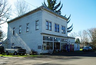
Commercial district in Charbonneau
Country United States
State Oregon
Region Clackamas County
City Wilsonville
Coordinates 45°17′14″N122°45′29″W / 45.28722°N 122.75806°W / 45.28722; -122.75806 Coordinates: 45°17′14″N122°45′29″W / 45.28722°N 122.75806°W / 45.28722; -122.75806
Timezone Pacific
Postal code 97070
Elevation 141 feet (43 m) [1]
Pond and footbridge Charbonneau Oregon pond.JPG
Pond and footbridge

Charbonneau (also known as the Charbonneau District) is a private planned community within the city limits of Wilsonville in Clackamas County, Oregon, United States. It is on the opposite side the Willamette River from the main area of the city. [2] The development was named for Jean Baptiste Charbonneau, the son of Sacagawea. [3]

Planned community any community or city that was carefully planned from its inception

A planned community, planned city, or planned town is any community that was carefully planned from its inception and is typically constructed on previously undeveloped land. This contrasts with settlements that evolve in a more ad hoc fashion. Land use conflicts are less frequent in these communities.

Wilsonville, Oregon City in Oregon, United States

Wilsonville is a city primarily in Clackamas County, Oregon, United States. A portion of the northern section of the city is in Washington County. It was founded as Boones Landing because of the Boones Ferry which crossed the Willamette River at the location; the community became Wilsonville in 1880. The city was incorporated in 1969 with a population of approximately 1,000. The population was 13,991 at the 2000 census, and grew to 19,509 as of 2010. Slightly more than 90% of residents at the 2000 census were white, with Hispanics comprising the largest minority group.

Clackamas County, Oregon County in the United States

Clackamas County is a county in the U.S. state of Oregon. As of the 2010 census, the population was 375,992, making it Oregon's third-most populous county. Its county seat is Oregon City. The county was named after the Native Americans living in the area, the Clackamas Indians, who were part of the Chinookan people.

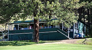
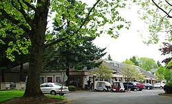
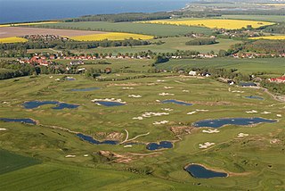
Charbonneau began in 1972 as a nine-hole golf course and 228 town homes; it now has a population of about 3,500 living in 1,158 multi-family units and 510 houses with an integrated 27-hole golf course. [4] There is also a small commercial district with about 10 shops including a grocery store and restaurant. [5] As one of the oldest communities of its type in Oregon, its construction helped lead to the adoption of land-use planning and an urban growth boundary to attempt to prevent urban sprawl. [5]

Golf course series of holes designed for the game of golf

A golf course is the grounds where the game of golf is played. It comprises a series of holes, each consisting of a teeing ground, a fairway, the rough and other hazards, and a green with a flagstick ("pin") and hole ("cup"). A standard round of golf consists of 18 holes. Most courses contain 18 holes; some share fairways or greens, and a subset has nine holes, played twice per round. Par-3 courses consist of nine or 18 holes all of which have a par of three strokes.

Land-use planning is the process of regulating the use of land in an effort to promote more desirable social and environmental outcomes as well as a more efficient use of resources. Goals of land-use planning may include environmental conservation, restraint of urban sprawl, minimization of transport costs, prevention of land-use conflicts, and a reduction in exposure to pollutants. By and large, the uses of land determine the diverse socioeconomic activities that occur in a specific area, the patterns of human behavior they produce, and their impact on the environment.

An urban growth boundary, or UGB, is a regional boundary, set in an attempt to control urban sprawl by, in its simplest form, mandating that the area inside the boundary be used for urban development and the area outside be preserved in its natural state or used for agriculture. Legislating for an "urban growth boundary" is one way, among many others, of managing the major challenges posed by unplanned urban growth and the encroachment of cities upon agricultural and rural land.

Charbonneau's 200 primary and secondary students are served by the Canby School District. [5]

Canby School District is an 85-square-mile (220 km2) public school district based in Canby, Oregon, United States, and serving students in Canby and the surrounding rural area of Clackamas County, including the community of Carus, parts of the city of Wilsonville, and as far south as the Ninety-One School near Hubbard. There are approximately 5,000 students enrolled in the district's eight schools, which include five elementary schools, one middle school, one K-8 school, and one high school. The superintendent is Jeff Rose.

Related Research Articles

Salem, Oregon State capital city in Oregon, United States

Salem is the capital of the U.S. state of Oregon, and the county seat of Marion County. It is located in the center of the Willamette Valley alongside the Willamette River, which runs north through the city. The river forms the boundary between Marion and Polk counties, and the city neighborhood of West Salem is in Polk County. Salem was founded in 1842, became the capital of the Oregon Territory in 1851, and was incorporated in 1857.

Lincoln City, Oregon City in Oregon, United States

Lincoln City is a city in Lincoln County on the Oregon Coast between Tillamook and Newport. It is named after the county, which was named in honor of former U.S. President Abraham Lincoln. The population was estimated to be 8,452 in 2016. During the solar eclipse of August 21, 2017, this city was the first in the path of totality to view a total solar eclipse.

Welches, Oregon Unincorporated community in Oregon, United States

Welches is an unincorporated community in Clackamas County, Oregon, United States. It is located within the Mount Hood Corridor between Zigzag and Wemme along U.S. Route 26. It is one of the communities that make up the Villages at Mount Hood.

Danner, Oregon Unincorporated community in Oregon, United States

Danner is an unincorporated community located in Malheur County, Oregon, United States. It lies along Danner Road off U.S. Route 95 west of Jordan Valley. Jordan Creek flows by Danner.

Oregon Institute of Technology

The Oregon Institute of Technology is a public polytechnic university in Oregon with a residential campus in Klamath Falls, Oregon, an urban campus in Wilsonville, Oregon, and additional locations in Salem, La Grande, and Seattle. Oregon Tech provides a total of 32 degree programs in engineering, health technologies, management, communication, psychology and applied sciences with a total of 37 majors. Almost all students complete externships, co-ops, or other hands-on training inside and outside the classroom.

Metro (Oregon regional government) regional government agency and metropolitan planning organization in the Oregon portion of the Portland metropolitan area

Metro is the regional government for the Oregon portion of the Portland metropolitan area. It is the only directly elected regional government and metropolitan planning organization in the United States. Metro is responsible for managing the Portland region's solid waste system, coordinating the growth of the cities in the region, managing a regional parks and natural areas system, and overseeing the Oregon Zoo, Oregon Convention Center, Portland's Centers for the Arts, and the Portland Expo Center.

Orenco, Oregon Neighborhood in Washington County, Oregon, United States

Orenco is a former company town in Washington County, Oregon, United States, located between Hillsboro and Aloha. The former community of Orenco now forms the Orenco neighborhood in Hillsboro, which is the site of the Orenco Station housing development.

Riviera Country Club

The Riviera Country Club is an exclusive private club with a championship golf course in the western United States, located in southern California in Pacific Palisades, a community within the city limits of Los Angeles. It's in Santa Monica Canyon, just below the Santa Monica Mountains and a block south of Sunset Boulevard. Designed by golf course architects George C. Thomas, Jr. and William P. Bell, it has been the primary host for the Genesis Open, an annual event on the PGA Tour in February. The 2018 edition was the 55th held at Riviera.

Oregon Route 551 highway in Oregon

Oregon Route 551 is an Oregon state highway that runs between the cities of Wilsonville and Hubbard. It is known as the Wilsonville-Hubbard Highway No. 51 and is also called the "Hubbard Cutoff." It is 5.94 miles (9.56 km) long, and is a two-lane limited access highway for its entire length.

South Metro Area Regional Transit

South Metro Area Regional Transit (SMART) is a public transit system operated by the city government of Wilsonville, Oregon, United States. The system currently consists of seven routes and is funded by local businesses. It was created when Wilsonville petitioned to withdraw from the TriMet service district in the late 1980s. Offices of the agency are in the former city hall off Wilsonville Road.

Sunriver, Oregon Census-designated place in Oregon, United States

Sunriver, Oregon is a census-designated place and 3,300-acre (13 km2) planned residential and resort community in Deschutes County, Oregon, United States. As of the 2010 census it had a population of 1,393. It is part of the Bend Metropolitan Statistical Area, located on the eastern side of the Deschutes River, about fifteen miles (25 km) south of Bend at the base of the Cascade Range.

Clackamas Community College

Clackamas Community College (CCC) is a community college located in Oregon City, Oregon, United States. Founded in 1966, it is one of the largest community colleges in the state of Oregon. Clackamas Community College offers courses at three campuses: the central campus in Oregon City, Harmony Community Campus in Clackamas, and the Wilsonville campus. Extension sites are also located in the towns of Canby and Molalla, where CCC offers English as a Second Language, GED in Spanish, computer science and community education classes. CCC is also the only college to offer an urban agriculture certificate in the state of Oregon.

Eagle Creek, Oregon Unincorporated community in Oregon, United States

Eagle Creek is an unincorporated community in Clackamas County, Oregon, United States. It is located seven miles southwest of Sandy, seven miles north of Estacada, and five miles southeast of Carver, at the junction of Oregon Routes 224 and 211, on the Clackamas River.

Christmas Valley, Oregon Unincorporated community in Oregon, United States

Christmas Valley is an unincorporated community in Lake County, Oregon, United States. The community was named after nearby Christmas Lake, usually dry, east of the present townsite and the site of the former Lake post office, which ran from 1906 until 1943. Real estate development around a planned community by M. Penn Phillips, called Christmas Valley, started after World War II. The Christmas Valley post office was established in 1963 as a rural station of Silver Lake.

The Reserve Vineyards and Golf Club

The Reserve Vineyards & Golf Club is a 36-hole private and public golf club in the northwest United States, located near Hillsboro, Oregon, a suburb west of Portland.

Kinzua, Oregon Ghost town in Oregon, United States

Kinzua is a ghost town or former town site in Wheeler County, Oregon, United States. It existed as company town from 1927 to 1978. Kinzua lies directly east of Fossil and uses a Fossil mailing address.

Robert McCallister is an American professional golfer who played on the PGA Tour and the Senior PGA Tour.

Town Center Park

Town Center Park is a small municipal park in Wilsonville, Oregon, United States. Located in the middle of Wilsonville's town center, the 5-acre (2.0 ha) park cost $4.5 million to complete. The park includes the Oregon Korean War Memorial, a visitor's center, paths, a play area, picnic tables, and an amphitheater among other features. Completed in 2005, Town Center Park is also home to Wilsonville's first interactive water feature.

Lancaster, Oregon Unincorporated community in Oregon, United States

Lancaster is an unincorporated community in Lane County, Oregon, United States. It is located about two miles south of Harrisburg and two miles north of Junction City, on Oregon Route 99E near the Willamette River.

References

  1. "Charbonneau". Geographic Names Information System . United States Geological Survey. March 29, 2012. Retrieved November 14, 2009.
  2. "City of Wilsonville" (PDF). Oregon Department of Transportation. 2011. Retrieved March 29, 2012.
  3. McArthur, Lewis A.; McArthur, Lewis L. (2003) [1928]. Oregon Geographic Names (7th ed.). Portland, Oregon: Oregon Historical Society Press. p. 190. ISBN   978-0875952772.
  4. "Charbonneau History". Charbonneau Country Club. Retrieved March 29, 2012.
  5. 1 2 3 Tims, Dana (April 19, 2001). "Southwest Zoner: Charbonneau, Setting the Tone". The Oregonian .