
Sandy is a city located in Clackamas County, Oregon, United States, settled c. 1853 and named after the nearby Sandy River. Located in the foothills of the Cascade Mountain Range, the city serves as the western gateway to the Mount Hood Corridor, and is located approximately 27 miles (43 km) east of Portland.

Troutdale is a city in Multnomah County, Oregon, United States, immediately north of Gresham and east of Wood Village. As of the 2010 census, the city population was 15,962. The city serves as the western gateway to the Historic Columbia River Highway, the Mount Hood Scenic Byway, and the Columbia River Gorge. It is approximately 12 miles (19 km) east of Portland.

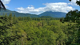
The Mount Hood Corridor is a part of Oregon between Sandy and Government Camp, in Clackamas County. It is named after Mount Hood and has served travelers going in both directions since the days of Native Americans and Oregon Trail migrants. The area between Alder Creek and Government Camp is sometimes known as Hoodland.

Rhododendron is an unincorporated community in Clackamas County, Oregon, United States. It is located within the Mount Hood Corridor, between Government Camp and Zigzag on U.S. Route 26. It is one of the communities that make up the Villages at Mount Hood.

Zigzag is an unincorporated community in Clackamas County, Oregon, United States. It is located within the Mount Hood Corridor, between Rhododendron and Welches on U.S. Route 26. The community is part of a local type of government called a village as one of the communities making up the Villages at Mount Hood, which stretches from the border of Sandy to Government Camp.
Welches is an unincorporated community in Clackamas County, Oregon, United States. It is located within the Mount Hood Corridor between Zigzag and Wemme along U.S. Route 26. It is one of the many communities that make up the Villages at Mount Hood.

Brightwood is an unincorporated community within the Mount Hood Corridor in Clackamas County, Oregon, United States. It is located between Wemme and Sandy just off U.S. Route 26 at an elevation of 1165 feet. It is one of the communities that make up the Villages at Mount Hood.

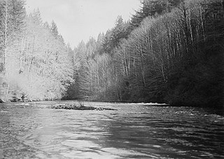
The Sandy River is a 56-mile (90 km) tributary of the Columbia River in northwestern Oregon in the United States. The Sandy joins the Columbia about 14 miles (23 km) upstream of Portland.

Mount Hood is an unincorporated community and census-designated place (CDP) in Hood River County, Oregon, United States, about 3 miles (5 km) northeast of Parkdale on Oregon Route 35. As of the 2010 census it had a population of 286. Mount Hood is the terminus of Oregon Route 281, the Hood River Highway.

The Barlow Road is a historic road in what is now the U.S. state of Oregon. It was built in 1846 by Sam Barlow and Philip Foster, with authorization of the Provisional Legislature of Oregon, and served as the last overland segment of the Oregon Trail. Its construction allowed covered wagons to cross the Cascade Range and reach the Willamette Valley, which had previously been nearly impossible. Even so, it was by far the most harrowing 100 miles (160 km) of the nearly 2,000-mile (3,200 km) Oregon Trail.

The Bull Run Hydroelectric Project was a Portland General Electric (PGE) development in the Sandy River basin in the U.S. state of Oregon. Originally built between 1908 and 1912 near the town of Bull Run, it supplied hydroelectric power for the Portland area for nearly a century, until it was removed in 2007 and 2008. The project used a system of canals, tunnels, wood box flumes and diversion dams to feed a remote storage reservoir and powerhouse. The entire project was removed because of rising environmental costs. Marmot Dam on the Sandy River was demolished in 2007, and the Little Sandy Dam on the Little Sandy River was taken down in 2008.

The Bull Run River is a 21.9-mile (35.2 km) tributary of the Sandy River in the U.S. state of Oregon. Beginning at the lower end of Bull Run Lake in the Cascade Range, it flows generally west through the Bull Run Watershed Management Unit (BRWMU), a restricted area meant to protect the river and its tributaries from contamination. The river, impounded by two artificial storage reservoirs as well as the lake, is the primary source of drinking water for the city of Portland, Oregon.

The Zigzag River is a tributary, about 12 miles (19 km) long, of the Sandy River in the U.S. state of Oregon. The Zigzag and one of its major tributaries, the Little Zigzag River, drain the Zigzag Glacier on Mount Hood, a high volcanic peak in the Cascade Range. Their waters flow westward to meet the Sandy River near the community of Zigzag. The river's flow ranges from 200 to 1,000 cubic feet per second.
Adolph Aschoff was a homesteader in the U.S. state of Oregon in the late 19th century. He established the community of Marmot, Oregon in the western foothills of Mount Hood in the late 19th century. Most of the buildings burned down in 1931.

Bull Run is an unincorporated community in Clackamas County, Oregon, United States. It is located about 5 miles northeast of Sandy, near the Bull Run River and the powerhouse of the defunct Mount Hood Railway and Power Company.
Cottrell is an unincorporated crossroads community in north Clackamas County, Oregon, United States. It was founded by Georgia Andrews, the wife of Charles Ida Andrews. Georgia and her mother Carrie Arabella (Townsley) Cottrell moved to Oregon from Milwaukee, Wisconsin after Georgia's father and Carrie's husband George Cottrell, was killed in a railroad accident. Georgia typically went by and wrote her name as 'Georgie'. There was a Cottrell post office from 1894 until 1904; it probably closed when Rural Free Delivery was extended to the area. There is also a Cottrell Road and a Cottrell school a mile east of the locale, and there was a Cottrell station on the defunct Mount Hood Electric Railway line about a mile to the north. The now-abandoned station was across the county line in Multnomah County. Georgia and her mother Carrie both died in Ashland, in 1953 and 1943 respectively.
Dee is an unincorporated community and former company town in Hood River County, Oregon, United States, on Oregon Route 281, about 11 miles south of Hood River.
The Little Sandy River is a tributary, roughly 15 miles (24 km) long, of the Bull Run River in the U.S. state of Oregon. Forming west of Mount Hood in the Mount Hood National Forest, it flows generally west, roughly parallel to the Sandy River to the south. Its entire course lies in Clackamas County, and most of its main stem and tributaries are within the Bull Run Watershed Management Unit (BRWMU), a restricted zone that protects Portland's main water supply.
Cherryville is an unincorporated community and former town in Clackamas County, Oregon, United States, founded in 1884. It is located approximately 6 miles (9.7 km) east of Sandy on U.S. Route 26, near the route of the Barlow Road.
Faubion is an unincorporated community in Clackamas County, Oregon, United States. It is located about 2 miles northwest of Rhododendron, in the Mount Hood Corridor on a loop road off U.S. Route 26 near the Zigzag River.


