Jennings Lodge, Oregon

Last updated

Jennings Lodge, Oregon
Clackamas County Oregon Incorporated and Unincorporated areas Jennings Lodge Highlighted.svg
Location of Jennings Lodge, Oregon
Coordinates: 45°23′35″N122°36′55″W / 45.39306°N 122.61528°W / 45.39306; -122.61528
Country United States
State Oregon
County Clackamas
Area
[1]
  Total1.67 sq mi (4.32 km2)
  Land1.59 sq mi (4.12 km2)
  Water0.08 sq mi (0.20 km2)
Elevation
[2]
95 ft (29 m)
Population
 (2020) [3]
  Total7,503
  Density4,718.87/sq mi (1,822.50/km2)
Time zone UTC-8 (Pacific (PST))
  Summer (DST) UTC-7 (PDT)
ZIP code
97267
Area code 503
FIPS code 41-37400 [4]
GNIS feature ID2408444 [2]

Jennings Lodge is a census-designated place and unincorporated community in Clackamas County, Oregon, United States, between Milwaukie and Gladstone. For statistical purposes, the United States Census Bureau has defined Jennings Lodge as a census-designated place (CDP). The census definition of the area may not precisely correspond to local understanding of the area with the same name. As of the United States Census, 2010, it had a total population of 7,315.

Contents

Even though Jennings Lodge is not part of Oregon City; the local elementary school (along with nearby Candy Lane Elementary) forms an exclave of the Oregon City School District.[ citation needed ]

History

According to Oregon Geographic Names , Jennings Lodge was platted as a townsite in 1905 and named after Berryman Jennings, an Oregon pioneer, one of whose children still owned Jennings' house in 1927.

Geography

Jennings Lodge is located along the Willamette River.

According to the United States Census Bureau, the CDP has a total area of 1.7 square miles (4.4 km2), of which 1.6 square miles (4.1 km2) is land and 0.1 square miles (0.26 km2) is water. The total area is 5.85% water.

Demographics

Historical population
CensusPop.Note
2020 7,503
U.S. Decennial Census [5] [3]

As of the census [4] of 2000, there were 7036 people in the area, organized into 2840 households and 1800 families. The population density was 4,368.1 inhabitants per square mile (1,686.5/km2). There were 3,004 housing units at an average density of 1,864.9 per square mile (720.0/km2). The racial makeup of the CDP was 89.10% White, 1.42% Asian, 0.87% Black or African American, 0.47% Native American, 0.13% Pacific Islander, 5.30% from other races, and 2.71% from two or more races. 10.77% of the population were Hispanic or Latino of any race.

There were 2,840 households, out of which 30.5% had children under the age of 18 living with them, 45.7% were married couples living together, 12.1% had a female householder with no husband present, and 36.6% were non-families. 28.3% of all households were made up of individuals, and 12.8% had someone living alone who was 65 years of age or older. The average household size was 2.47 and the average family size was 3.03.

The population was spread out, with 25.1% under the age of 18, 9.8% from 18 to 24, 29.9% from 25 to 44, 21.6% from 45 to 64, and 13.6% who were 65 years of age or older. The median age was 36 years. For every 100 females, there were 94.5 males. For every 100 females age 18 and over, there were 91.4 males.

The median income for a household in the CDP was $43,159, and the median income for a family was $50,996. Males had a median income of $38,850 versus $26,913 for females. The per capita income for the CDP was $19,891. 10.5% of the population and 6.8% of families were below the poverty line. Out of the total population, 15.0% of those under the age of 18 and 5.2% of those 65 and older were living below the poverty line.

Related Research Articles

<span class="mw-page-title-main">Pinson, Alabama</span> City in Alabama, United States

Pinson is a city in Jefferson County near Birmingham, Alabama, United States, northwest of Center Point. As of the 2010 census, the population was 7,163.

<span class="mw-page-title-main">Lodge Pole, Montana</span> Census-designated place in Montana, United States

Lodge Pole is a census-designated place (CDP) in Blaine County, Montana, United States. The population was 265 at the 2010 census. It lies within the Fort Belknap Indian Reservation, near the reservation's southern end.

<span class="mw-page-title-main">Oak Grove, Oregon</span> Unincorporated community in the state of Oregon, United States

Oak Grove is an unincorporated community in Clackamas County, Oregon, United States, in the Portland metropolitan area. For statistical purposes, the United States Census Bureau has defined Oak Grove as a census-designated place (CDP). The census definition of the area may not precisely correspond to local understanding of the area with the same name. The population was 16,629 at the 2010 census.

<span class="mw-page-title-main">Oatfield, Oregon</span> Unincorporated community in the state of Oregon, United States

Oatfield is an unincorporated community and census-designated place in Clackamas County, Oregon, United States. It is in the Portland metropolitan area. As of the 2010 census, the population of the CDP was 13,415.

<span class="mw-page-title-main">Bunker Hill, Oregon</span> CDP in Oregon, United States

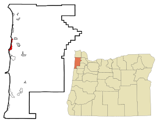
Bunker Hill is a census-designated place (CDP) in Coos County, Oregon, United States. As of the 2010 census the population was 1,444.

<span class="mw-page-title-main">Green, Oregon</span> Unincorporated community in the state of Oregon, United States

Green is a census-designated place (CDP) and unincorporated community in Douglas County, Oregon, United States. The population was 7,614 at the 2020 census.

<span class="mw-page-title-main">Roseburg North, Oregon</span> CDP in Oregon, United States

Roseburg North is a census-designated place (CDP) in Douglas County, Oregon, United States. The population was 5,912 at the 2010 census. Winchester, Oregon is included as part of Roseburg North.

<span class="mw-page-title-main">Rose Lodge, Oregon</span> Unincorporated community in the state of Oregon, United States

Rose Lodge is a census-designated place (CDP) and unincorporated community in Lincoln County, Oregon, United States, along the 45th parallel. The population was 1,894 at the 2010 census.

<span class="mw-page-title-main">Marion, Oregon</span> Unincorporated community in the state of Oregon, United States

Marion is an unincorporated community in Marion County, Oregon, United States. For statistical purposes, the United States Census Bureau has defined Marion as a census-designated place (CDP). The census definition of the area may not precisely correspond to local understanding of the area with the same name. The population was 307 at the 2020 census. Marion is part of the Salem Metropolitan Statistical Area.

<span class="mw-page-title-main">Mehama, Oregon</span> Unincorporated community in the state of Oregon, United States

Mehama is an unincorporated community in Marion County, Oregon, United States, located on Oregon Route 22 and the North Santiam River. For statistical purposes, the United States Census Bureau has defined Mehama as a census-designated place (CDP). The census definition of the area may not precisely correspond to local understanding of the area with the same name. The population was 317 at the 2020 census. It is part of the Salem Metropolitan Statistical Area.

<span class="mw-page-title-main">Rickreall, Oregon</span> Unincorporated community in the state of Oregon, United States

Rickreall is an unincorporated community in Polk County, Oregon, United States. For statistical purposes, the United States Census Bureau has defined Rickreall as a census-designated place (CDP). The census definition of the area may not precisely correspond to local understanding of the area with the same name. The population of the CDP was 76 at the 2020 census. Rickreall is part of the Salem Metropolitan Statistical Area. Rickreall Creek runs along the community's southern edge.

<span class="mw-page-title-main">Beaver, Oregon</span> Unincorporated community in the state of Oregon, United States

Beaver is an unincorporated community in Tillamook County, Oregon, United States, along U.S. Route 101 and the Nestucca River, about 12 miles (19 km) south of Tillamook. For statistical purposes, the United States Census Bureau has defined Beaver as a census-designated place (CDP). The census definition of the area may not precisely correspond to local understanding of the area with the same name. The population of the CDP was 122 at the 2010 census.

<span class="mw-page-title-main">Cape Meares, Oregon</span> Unincorporated community in the state of Oregon, United States

Cape Meares is a census-designated place (CDP) and unincorporated community in Tillamook County, Oregon, United States. The population was 110 at the 2000 census.

<span class="mw-page-title-main">Cayuse, Oregon</span> Unincorporated community in the state of Oregon, United States

Cayuse is a census-designated place (CDP) and unincorporated community in Umatilla County, Oregon, United States, located 11 miles (18 km) east of Pendleton on the Umatilla Indian Reservation. The population was 59 at the 2000 census. It is part of the Pendleton–Hermiston Micropolitan Statistical Area.

<span class="mw-page-title-main">Kirkpatrick, Oregon</span> Unincorporated community in the state of Oregon, United States

Kirkpatrick is a census-designated place (CDP) in Umatilla County, Oregon, United States. The population was 172 at the 2000 census. It is part of the Pendleton–Hermiston Micropolitan Statistical Area.

<span class="mw-page-title-main">Mission, Oregon</span> Unincorporated community in the state of Oregon, United States

Mission is an unincorporated community in Umatilla County, Oregon, United States. For statistical purposes, the United States Census Bureau has defined Mission as a census-designated place (CDP). The population was 1,019 at the 2000 census.

<span class="mw-page-title-main">Chenoweth, Oregon</span> Community in Oregon, United States

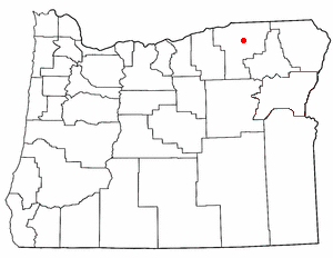
Chenoweth is an unincorporated community in Wasco County, Oregon, United States. Locally the alternative spelling of Chenowith is used, such as for the 'Chenowith Elementary School'. For statistical purposes, the United States Census Bureau has defined Chenoweth as a census-designated place (CDP). The census definition of the area may not precisely correspond to local understanding of the area with the same name. The population of the CDP was 3,412 at the 2000 census.
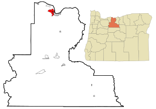
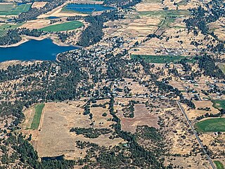
<span class="mw-page-title-main">Wamic, Oregon</span> Unincorporated community in the state of Oregon, United States

Wamic is a census-designated place (CDP) and unincorporated community in Wasco County, Oregon, United States. Wamic was named for the Womack family, which settled the area. A post office was established at Wamic in 1884 and it closed in 1958. The population was 36 at the 2000 census.

<span class="mw-page-title-main">Frederickson, Washington</span> CDP in Washington, United States

Frederickson is a census-designated place (CDP) in Pierce County, Washington, United States. The population was 24,906 at the 2020 census.

<span class="mw-page-title-main">Hillandale, Maryland</span> Census-designated place in Maryland, United States

Hillandale is an unincorporated area and census-designated place located in Montgomery and Prince George's counties, Maryland, United States. As of the 2020 census, it had a population of 5,774. Hillandale is contained between the Prince George's / Montgomery County line to the east, the Anacostia River to the west, McCeney Avenue to the north, and D.C.'s Capital Beltway to the south. It borders the communities of Adelphi, Avenel, White Oak and Beltsville.

References

  1. "ArcGIS REST Services Directory". United States Census Bureau. Retrieved October 12, 2022.
  2. 1 2 U.S. Geological Survey Geographic Names Information System: Jennings Lodge, Oregon
  3. 1 2 "Census Population API". United States Census Bureau. Retrieved October 12, 2022.
  4. 1 2 "U.S. Census website". United States Census Bureau . Retrieved January 31, 2008.
  5. "Census of Population and Housing". Census.gov. Retrieved June 4, 2016.