Oak Grove, Oregon

Last updated

Oak Grove, Oregon
Oak Grove Oregon.jpg
View from main street (Oak Grove Boulevard) in Oak Grove
Clackamas County Oregon Incorporated and Unincorporated areas Oak Grove Highlighted.svg
Location of Oak Grove, Oregon
Coordinates: 45°24′56″N122°38′05″W / 45.41556°N 122.63472°W / 45.41556; -122.63472
Country United States
State Oregon
County Clackamas
Area
[1]
  Total4.17 sq mi (10.80 km2)
  Land3.90 sq mi (10.11 km2)
  Water0.27 sq mi (0.69 km2)
Elevation
[2]
200 ft (60 m)
Population
 (2020) [3]
  Total17,290
  Density4,429.93/sq mi (1,710.30/km2)
Time zone UTC-8 (Pacific (PST))
  Summer (DST) UTC-7 (PDT)
ZIP codes
97222, 97267, 97268
Area code(s) 503, 971
FIPS code 41-53900 [4]
GNIS feature ID2408962 [2]

Oak Grove is an unincorporated community in Clackamas County, Oregon, United States, in the Portland metropolitan area. For statistical purposes, the United States Census Bureau has defined Oak Grove as a census-designated place (CDP). The census definition of the area may not precisely correspond to local understanding of the area with the same name. The population was 16,629 at the 2010 census. [5]

Contents

History

New Urban High School, 2009 New Urban High School Milwaukie Oregon.jpg
New Urban High School, 2009
Sign during the 1973 oil crisis FUEL SHORTAGE IN THE PACIFIC NORTHWEST RESULTED IN A SIGN ABOUT SHORTER HOURS LIKE THIS AT A GASOLINE STATION AT OAK... - NARA - 555452.tif
Sign during the 1973 oil crisis

Oak Grove was named at the suggestion of Edward W. Cornell, a member of the surveying party that platted the townsite in the 1890s. [6] The company that was developing the property had not been able to come up with a good name for the place, and Cornell suggested "Oak Grove" after a crew ate lunch in a stand of oak trees in the northwestern part of the tract. [6]

The area was served first from the Milwaukie post office. [6] In 1904, Creighton post office was established, named for Susan Creighton, on whose donation land claim the office stood. [6] Postal authorities did not name the office "Oak Grove" in order to avoid duplication. [6] There had once been an Oak Grove post office in Josephine County. [7] The first postmaster was noted Oregon botanist Thomas J. Howell. [6]

Oak Grove railroad station was originally named "Center", and another station, St. Theresa, was originally named "Oak Grove". [6] In order to prevent confusion, in 1907 the Post Office Department changed the name of the post office to "Oak Grove", and the Center railroad station was renamed to match. [6] The railroad no longer passes through the community. [6]

Concord School is a historic building and former school (Concord Elementary School) in Oak Grove.

Oak Grove is home to a LINCC library operated by Clackamas County. [8]

Geography

Oak Grove is located in northwestern Clackamas County, bordered to the north by the city of Milwaukie, to the east by unincorporated Oatfield, to the south by unincorporated Jennings Lodge, and to the west by the Willamette River, whose opposite shore hosts the cities of West Linn and Lake Oswego. Oregon Route 99E runs through Oak Grove as McLoughlin Boulevard; it leads north 8 miles (13 km) to downtown Portland and south 4 miles (6 km) to Oregon City.

According to the United States Census Bureau, the Oak Grove CDP has a total area of 4.1 square miles (10.7 km2), of which 3.9 square miles (10.1 km2) is land and 0.27 square miles (0.7 km2), or 6.35%, is water. [5]

Hog Island, an island in the Willamette River, is located within the boundaries of Oak Grove.

Demographics

Historical population
CensusPop.Note
2020 17,290
U.S. Decennial Census [9] [3]

As of the census [4] of 2000, there were 12,808 people, 5,641 households, and 3,249 families residing in the CDP. The population density was 4,379.6 inhabitants per square mile (1,691.0/km2). There were 6,015 housing units at an average density of 2,056.8 per square mile (794.1/km2). The racial makeup of the CDP was 91.47% White, 0.56% African American, 0.78% Native American, 1.79% Asian, 0.10% Pacific Islander, 2.55% from other races, and 2.75% from two or more races. Hispanic or Latino of any race were 5.89% of the population.

There were 5,641 households, out of which 24.7% had children under the age of 18 living with them, 43.9% were married couples living together, 9.9% had a female householder with no husband present, and 42.4% were non-families. 35.2% of all households were made up of individuals, and 18.8% had someone living alone who was 65 years of age or older. The average household size was 2.24 and the average family size was 2.89.

In the CDP, the population was spread out, with 21.5% under the age of 18, 7.5% from 18 to 24, 27.5% from 25 to 44, 23.3% from 45 to 64, and 20.2% who were 65 years of age or older. The median age was 40 years. For every 100 females, there were 89.0 males. For every 100 females age 18 and over, there were 85.8 males.

The median income for a household in the CDP was $40,530, and the median income for a family was $49,141. Males had a median income of $36,867 versus $29,877 for females. The per capita income for the CDP was $22,643. About 6.6% of families and 8.8% of the population were below the poverty line, including 14.1% of those under age 18 and 7.0% of those age 65 or over.

See also

Related Research Articles

<span class="mw-page-title-main">Washington County, Oregon</span> County in Oregon, United States

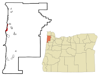
Washington County is one of 36 counties in the U.S. state of Oregon and part of the Portland metropolitan area. The 2020 census recorded the population as 600,372, making it the second most populous county in the state and most populous "Washington County" in the United States. Hillsboro is the county seat and largest city, while other major cities include Beaverton, Tigard, Cornelius, Banks, Gaston, Sherwood, North Plains, and Forest Grove, the county's oldest city. Originally named Twality when created in 1843, the Oregon Territorial Legislature renamed it for the nation's first president in 1849 and included the entire northwest corner of Oregon before new counties were created in 1854. The Tualatin River and its drainage basin lie almost entirely within the county, which shares its boundaries with the Tualatin Valley. It is bordered on the west and north by the Northern Oregon Coast Range, on the south by the Chehalem Mountains, and on the north and east by the Tualatin Mountains, or West Hills.

<span class="mw-page-title-main">Clackamas County, Oregon</span> County in Oregon, United States

Clackamas County is one of the 36 counties in the U.S. state of Oregon. As of the 2020 census, the population was 421,401, making it Oregon's third-most populous county. Its county seat is Oregon City. The county was named after the American Indians living in the area, the Clackamas people, who are part of the Chinookan peoples.

<span class="mw-page-title-main">Clackamas, Oregon</span> Unincorporated community in the state of Oregon, United States

Clackamas is an unincorporated community and former census-designated place (CDP) in Clackamas County, Oregon, United States, and is a suburb of Portland. The population was approximately 7,000 as of 2010.

<span class="mw-page-title-main">Jennings Lodge, Oregon</span> Unincorporated community in the state of Oregon, United States

Jennings Lodge is a census-designated place and unincorporated community in Clackamas County, Oregon, United States, between Milwaukie and Gladstone. For statistical purposes, the United States Census Bureau has defined Jennings Lodge as a census-designated place (CDP). The census definition of the area may not precisely correspond to local understanding of the area with the same name. As of the United States Census, 2010, it had a total population of 7,315.

<span class="mw-page-title-main">Mount Hood Village, Oregon</span> Unincorporated community in the state of Oregon, United States

Mount Hood Village is the name of a census-designated place (CDP) within the Mount Hood Corridor in Clackamas County, Oregon, United States. As of the 2010 census, the CDP had a population of 4,864. The Villages at Mount Hood is the name of the combined government of several of the communities encompassed by the CDP and is a separate entity.

<span class="mw-page-title-main">Oatfield, Oregon</span> Unincorporated community in the state of Oregon, United States

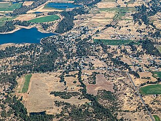
Oatfield is an unincorporated community and census-designated place in Clackamas County, Oregon, United States. It is in the Portland metropolitan area. As of the 2010 census, the population of the CDP was 13,415.

<span class="mw-page-title-main">Sunnyside, Clackamas County, Oregon</span> Unincorporated community in the state of Oregon, United States

Sunnyside is a former census-designated place in Clackamas County in the U.S. state of Oregon. Located in the Portland metropolitan area along Interstate 205, the population was 6,791 at the 2000 census. The area was not recorded as a distinct place for the 2010 census.

<span class="mw-page-title-main">Rose Lodge, Oregon</span> Unincorporated community in the state of Oregon, United States

Rose Lodge is a census-designated place (CDP) and unincorporated community in Lincoln County, Oregon, United States, along the 45th parallel. The population was 1,894 at the 2010 census.

<span class="mw-page-title-main">Butteville, Oregon</span> Unincorporated community in the state of Oregon, United States

Butteville is a census-designated place and unincorporated community in Marion County, Oregon, United States. For statistical purposes, the United States Census Bureau has defined Butteville as a census-designated place (CDP). The census definition of the area may not precisely correspond to local understanding of the area with the same name. As of the 2020 census the population was 273. It is part of the Salem Metropolitan Statistical Area.

<span class="mw-page-title-main">Mehama, Oregon</span> Unincorporated community in the state of Oregon, United States

Mehama is an unincorporated community in Marion County, Oregon, United States, located on Oregon Route 22 and the North Santiam River. For statistical purposes, the United States Census Bureau has defined Mehama as a census-designated place (CDP). The census definition of the area may not precisely correspond to local understanding of the area with the same name. The population was 317 at the 2020 census. It is part of the Salem Metropolitan Statistical Area.

<span class="mw-page-title-main">Eola, Oregon</span> Unincorporated community in the state of Oregon, United States

Eola is an unincorporated community in Polk County, Oregon, United States four miles west of Salem on Oregon Route 22 at the confluence of Rickreall Creek and the Willamette River.

<span class="mw-page-title-main">Rickreall, Oregon</span> Unincorporated community in the state of Oregon, United States

Rickreall is an unincorporated community in Polk County, Oregon, United States. For statistical purposes, the United States Census Bureau has defined Rickreall as a census-designated place (CDP). The census definition of the area may not precisely correspond to local understanding of the area with the same name. The population of the CDP was 76 at the 2020 census. Rickreall is part of the Salem Metropolitan Statistical Area. Rickreall Creek runs along the community's southern edge.

<span class="mw-page-title-main">Beaver, Oregon</span> Unincorporated community in the state of Oregon, United States

Beaver is an unincorporated community in Tillamook County, Oregon, United States, along U.S. Route 101 and the Nestucca River, about 12 miles (19 km) south of Tillamook. For statistical purposes, the United States Census Bureau has defined Beaver as a census-designated place (CDP). The census definition of the area may not precisely correspond to local understanding of the area with the same name. The population of the CDP was 122 at the 2010 census.

<span class="mw-page-title-main">Cape Meares, Oregon</span> Unincorporated community in the state of Oregon, United States

Cape Meares is a census-designated place (CDP) and unincorporated community in Tillamook County, Oregon, United States. The population was 110 at the 2000 census.

<span class="mw-page-title-main">Cloverdale, Oregon</span> Census-designated place in Oregon, United States

Cloverdale is an unincorporated community in Tillamook County, Oregon, United States. For statistical purposes, the United States Census Bureau has defined Cloverdale as a census-designated place (CDP). The census definition of the area may not precisely correspond to local understanding of the area with the same name. The population was 242 at the 2000 census.

<span class="mw-page-title-main">Cayuse, Oregon</span> Unincorporated community in the state of Oregon, United States

Cayuse is a census-designated place (CDP) and unincorporated community in Umatilla County, Oregon, United States, located 11 miles (18 km) east of Pendleton on the Umatilla Indian Reservation. The population was 59 at the 2000 census. It is part of the Pendleton–Hermiston Micropolitan Statistical Area.

<span class="mw-page-title-main">Wamic, Oregon</span> Unincorporated community in the state of Oregon, United States

Wamic is a census-designated place (CDP) and unincorporated community in Wasco County, Oregon, United States. Wamic was named for the Womack family, which settled the area. A post office was established at Wamic in 1884 and it closed in 1958. The population was 36 at the 2000 census.

<span class="mw-page-title-main">West Haven-Sylvan, Oregon</span> CDP in Oregon, United States

West Haven-Sylvan is a census-designated place (CDP) in Washington and Multnomah counties, Oregon, United States, north of U.S. Route 26. As of the 2020 census, the CDP population was 9,299.

<span class="mw-page-title-main">Barberton, Washington</span> Census-designated place in Washington, United States

Barberton is a census-designated place (CDP) in Clark County, Washington, United States. The population was 5,661 at the 2010 census, up from 4,617 at the 2000 census.

<span class="mw-page-title-main">Milwaukie, Oregon</span> City in Oregon, United States

Milwaukie is a city mostly in Clackamas County, Oregon, United States; a very small portion of the city extends into Multnomah County. The population was 21,119 at the 2020 census. Founded in 1847 on the banks of the Willamette River, the city, known as the Dogwood City of the West, was incorporated in 1903 and is the birthplace of the Bing cherry. The city is now a suburb of Portland and also adjoins the unincorporated areas of Clackamas and Oak Grove.

References

  1. "ArcGIS REST Services Directory". United States Census Bureau. Retrieved October 12, 2022.
  2. 1 2 U.S. Geological Survey Geographic Names Information System: Oak Grove, Oregon
  3. 1 2 "Census Population API". United States Census Bureau. Retrieved October 12, 2022.
  4. 1 2 "U.S. Census website". United States Census Bureau . Retrieved January 31, 2008.
  5. 1 2 "Geographic Identifiers: 2010 Demographic Profile Data (G001): Oak Grove CDP, Oregon". U.S. Census Bureau, American Factfinder. Archived from the original on March 10, 2015. Retrieved March 9, 2015.
  6. 1 2 3 4 5 6 7 8 9 McArthur, Lewis A.; Lewis L. McArthur (2003) [1928]. Oregon Geographic Names (7th ed.). Portland, Oregon: Oregon Historical Society Press. p. 713. ISBN   0-87595-277-1.
  7. U.S. Geological Survey Geographic Names Information System: Oak Grove Post Office (historical)
  8. Library Hours & Locations Archived September 14, 2010, at the Wayback Machine from the Clackamas County website
  9. "Census of Population and Housing". Census.gov. Retrieved June 4, 2016.