West Linn is a city in Clackamas County, Oregon, United States. A southern suburb within the Portland metropolitan area, West Linn developed out of Linn City, an earlier settlement built around the Sullivan hydroelectric plant that harvested energy from nearby Willamette Falls. It was named after U.S. Senator Lewis F. Linn of Ste. Genevieve, Missouri, who had advocated the American occupation of Oregon as a counterclaim to the British. As of the 2010 census, the city had a population of 25,109.

The Tualatin River is a tributary of the Willamette River in Oregon in the United States. The river is about 83 miles (134 km) long, and it drains a fertile farming region called the Tualatin Valley southwest and west of Portland at the northwest corner of the Willamette Valley. There are approximately 500,000 people residing on 15 percent of the land in the river's watershed.

The Portland metropolitan area is a metro area in the U.S. states of Oregon and Washington centered on the principal city of Portland, Oregon. The U.S. Office of Management and Budget (OMB) identifies it as the Portland–Vancouver–Hillsboro, OR–WA Metropolitan Statistical Area, a metropolitan statistical area used by the United States Census Bureau (USCB) and other entities. The OMB defines the area as comprising Clackamas, Columbia, Multnomah, Washington, and Yamhill Counties in Oregon, and Clark and Skamania Counties in Washington. The area's population is estimated at 2,753,168 in 2017.
Interstate 205 (I-205) is an auxiliary Interstate Highway in the Portland metropolitan area of Oregon and Washington. The north–south freeway serves as a bypass route of I-5 along the east side of Portland, Oregon, and Vancouver, Washington. It intersects several major highways and serves Portland International Airport.

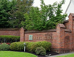
Marylhurst University was a private applied liberal arts and business university in Marylhurst, Oregon. It was among the oldest collegiate degree-granting institutions in Oregon, having awarded its first degree in 1897. Marylhurst was founded as St. Mary's College and run for many years by the Sisters of the Holy Names of Jesus and Mary. The former campus is located about nine miles south of Portland, Oregon on the Willamette River. Although Marylhurst University was a Roman Catholic school, it served students of all faiths and backgrounds.

Dunthorpe is an affluent unincorporated suburb of Portland, Oregon, United States. It is located just south of the Portland city limits and north of the Multnomah County line on the west side of the Willamette River. Lewis & Clark College, Tryon Creek State Park, and Lake Oswego are nearby.

Oregon Route 43 is an Oregon state highway that runs between the cities of Oregon City and Portland, mostly along the western flank of the Willamette River. While it is technically known by the Oregon Department of Transportation as the Oswego Highway No. 3, on maps it is referred to by its route number or by the various street names it has been given.
Lake Grove is a neighborhood of Lake Oswego, Oregon, United States, located west of Oswego Lake, south of the Mountain Park neighborhood, east of Interstate 5, and north of Rivergrove.
Collins View is a neighborhood in the Southwest section of Portland, Oregon. It borders the neighborhoods of Marshall Park and Arnold Creek to the west, Tryon Creek State Natural Area to the south, Dunthorpe, River View Cemetery and River View Natural Area to the east, and the South Burlingame neighborhood to the north. The campus of Lewis & Clark College is located the southeastern portion of the neighborhood.
Far Southwest is a neighborhood in the Southwest section of Portland, Oregon. It is bordered on the west by I-5; on the north by I-5, SW Pasadena St., and SW Pomona St.; on the east by SW 49th Ave. and Kerr Parkway; and on the south by SW Kruse Ridge Dr. and the southern border of the Portland Community College Sylvania Campus. The neighborhood is adjacent to the city of Tigard on the west, the neighborhoods of Ashcreek and Crestwood on the north, West Portland Park on the north and east, and the city of Lake Oswego on the east and south.

Stafford is an unincorporated community, classified as a hamlet, in Clackamas County, Oregon, United States. It is a census-designated place (CDP), with a population of 1,577 as of the 2010 census. The community covers approximately 15.7 km2 located in a rough triangle south of Lake Oswego, east of Tualatin, and west of West Linn. Students in the area attend the schools of the West Linn-Wilsonville School District.
The West Linn Tidings is a weekly newspaper published in West Linn, Oregon, United States, a suburb of Portland. It is owned by the Pamplin Media Group. It was founded in 1980, and was published by the Lake Oswego Review prior to its purchase by the Pamplin group.

Crystal Springs Creek, a 2.7-mile (4.3 km) tributary of Johnson Creek, flows entirely within the city of Portland in the U.S. state of Oregon. The stream rises from springs near the Reed College campus in the southeastern part of the city and runs generally southwest to meet Johnson Creek in the Portland neighborhood of Sellwood.
Shadowood is an unincorporated community in Clackamas County, Oregon, United States, about four miles south of Lake Oswego on the Tualatin River east of Shipley Bridge. Its elevation is 190 feet. Shadowood has a West Linn ZIP code.

The B.P. John Administrative Building is a building on the now defunct Marylhurst University campus, in Marylhurst, Oregon, United States. It was designed by Joseph Jacobberger and completed in 1929. The building originally housed the entire college, and included an auditorium, a bakery and cafeteria, a chapel, classrooms, a gymnasium, a library, and a swimming pool. The second floor originally had living areas for the Sisters of the Holy Names. The 100-seat music venue Wiegand Hall was added during the 1990s. In 2013, the building's chapel was renovated. The university closed in late 2018.

Flavia Hall is a building on the now defunct Marylhurst University campus, in Marylhurst, Oregon, United States. It was designed by architects Joseph Jacobberger and Alfred H. Smith, and completed c. 1937. The building originally served as a dormitory, and was later converted into an office building. The university closed in late 2018.

Sisters' Cemetery, also known as Holy Names Cemetery, is a cemetery adjacent to the Marylhurst University campus, in Marylhurst, Oregon, United States. It is owned by the Sisters of the Holy Names of Jesus and Mary (SNJM), U.S.-Ontario Province and maintained by the SNJM Oregon Regional Office.

Aquinas Hall is a building on the now defunct Marylhurst University campus in Marylhurst, Oregon, United States. The building was designed by Joseph Jacobberger and Alfred Smith, and completed c. 1930. Aquinas Hall exhibits the Mediterranean architectural style, and was used as student housing, and later administrative offices until the university closed in late 2018.

St. Catherine Hall, original known as St. Rose's Residence Hall, is a building on the now defunct Marylhurst University campus in Marylhurst, Oregon, United States. It was built during the 1930s. The university closed in late 2018.
The Street of Dreams is an annual showcase of new homes in the Portland metropolitan area of Oregon, U.S. It is put on by the Home Builders Association of Metropolitan Portland and features high-end homes designed to showcase new designs and amenities. Started in 1976, a previous incarnation of the event was known as the Parade of Homes.