Brightwood, Oregon

Last updated

Brightwood
Brightwood.jpg
Coordinates: 45°22′30″N122°01′12″W / 45.37500°N 122.02000°W / 45.37500; -122.02000
Country United States
State Oregon
County Clackamas
Elevation
[1]
1,145 ft (349 m)
Time zone UTC-8 (Pacific (PST))
  Summer (DST) UTC-7 (PDT)
ZIP codes
97011
GNIS feature ID1167849 [1]

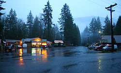
Brightwood is an unincorporated community within the Mount Hood Corridor in Clackamas County, Oregon, United States. It is located between Wemme and Sandy just off U.S. Route 26 at an elevation of 1165 feet (355 meters). It is one of the communities that make up the Villages at Mount Hood.

Contents

A post office called "Salmon" was established in the area in 1891, named after the nearby Salmon River. [2] The post office was renamed Brightwood in 1910. [2] The name Brightwood was said to have been coined by a local resident, Mr. Alcorn, for the pleasing effect of the sun shining on the cottonwood trees in the spring. [2]

Climate

This region experiences warm and dry summers, with no average monthly temperatures above 71.6 °F (22.0 °C). According to the Köppen Climate Classification system, Brightwood has a warm-summer Mediterranean climate, abbreviated "Csb" on climate maps. [3]

Notable people

See also

Related Research Articles

<span class="mw-page-title-main">Rhododendron, Oregon</span> Unincorporated community in the state of Oregon, United States

Rhododendron is an unincorporated community in Clackamas County, Oregon, United States. It is located within the Mount Hood Corridor, between Government Camp and Zigzag on U.S. Route 26. It is one of the communities that make up the Villages at Mount Hood.

<span class="mw-page-title-main">Zigzag, Oregon</span> Unincorporated community in the state of Oregon, United States

Zigzag is an unincorporated community in Clackamas County, Oregon, United States. It is located within the Mount Hood Corridor, between Rhododendron and Welches on U.S. Route 26. The community is part of a local type of government called a village as one of the communities making up the Villages at Mount Hood, which stretches from the border of Sandy to Government Camp.

<span class="mw-page-title-main">Welches, Oregon</span> Unincorporated community in the state of Oregon, United States

Welches is an unincorporated community in Clackamas County, Oregon, United States. It is located within the Mount Hood Corridor between Zigzag and Wemme along U.S. Route 26. It is one of the many communities that make up the Villages at Mount Hood.

<span class="mw-page-title-main">Wemme, Oregon</span> Unincorporated community in the state of Oregon, United States

Wemme is an unincorporated community in the northwest United States, located in Clackamas County, Oregon, east of Portland. It is located within the Mount Hood Corridor, between Welches and Brightwood along U.S. Route 26. It is one of the communities that make up the Villages at Mount Hood.

<span class="mw-page-title-main">Otis, Oregon</span> Unincorporated community in the state of Oregon, United States

Otis is an unincorporated community in Lincoln County, Oregon, United States, a half mile north of Otis Junction on Oregon Route 18. It is near the Salmon River.

Midland is an unincorporated community in Klamath County, Oregon, United States, about 8 miles (13 km) south of Klamath Falls on U.S. Route 97. The site was platted in 1908 and named Midland, with a post office established in 1909. At the time it was said the name was chosen because the town was halfway between Portland and San Francisco on the proposed Cascade Line of the Southern Pacific Railroad. It is not halfway, however, and it is now thought that the name refers to the town's site on land partly surrounded by marshes.

<span class="mw-page-title-main">Mount Hood, Oregon</span> Unincorporated community in the state of Oregon, United States

Mount Hood is an unincorporated community and census-designated place (CDP) in Hood River County, Oregon, United States, about 3 miles (5 km) northeast of Parkdale on Oregon Route 35. As of the 2010 census it had a population of 286. Mount Hood is the terminus of Oregon Route 281, the Hood River Highway.

<span class="mw-page-title-main">Alvadore, Oregon</span> Unincorporated community in the state of Oregon, United States

Alvadore is an unincorporated community in Lane County, Oregon, United States, located nine miles northwest of downtown Eugene and one mile northeast of Fern Ridge Reservoir.

<span class="mw-page-title-main">Mulino, Oregon</span> Unincorporated community in the state of Oregon, United States

Mulino, Oregon is a hamlet and census-designated place (CDP) located in Clackamas County, Oregon, United States, on Oregon Route 213 between the cities of Oregon City and Molalla. As of the 2010 census it had a population of 2,103.

<span class="mw-page-title-main">Eagle Creek, Oregon</span> Unincorporated community in the state of Oregon, United States

Eagle Creek is an unincorporated community in Clackamas County, Oregon, United States. It is located seven miles southwest of Sandy, seven miles north of Estacada, and five miles southeast of Carver, at the junction of Oregon Routes 224 and 211, on the Clackamas River.

<span class="mw-page-title-main">Days Creek, Oregon</span> Unincorporated community in the state of Oregon, United States

Days Creek is an unincorporated community and census-designated place in Douglas County, Oregon, United States. At the 2010 census it had a population of 272.

<span class="mw-page-title-main">Wedderburn, Oregon</span> Unincorporated community in the state of Oregon, United States

Wedderburn is an unincorporated coastal community in Curry County, Oregon, United States. It is to the north of, and across the mouth of the Rogue River from Gold Beach, on U.S. Route 101. The Isaac Lee Patterson Bridge connects Wedderburn with Gold Beach.

Marmot is an unincorporated community in Clackamas County, Oregon, United States located in the Mount Hood Corridor. It is within the boundaries of the Villages at Mount Hood, on a ridge known as Devil's Backbone, which lies between the Sandy and Little Sandy rivers, along the historic Barlow Road.

London Springs is an unincorporated community in Lane County, Oregon, United States. It lies 11.33 miles (18.23 km) south-southwest of Cottage Grove at an elevation of 896 feet (273 m). London Springs is near the Coast Fork Willamette River, south of Cottage Grove Lake.

<span class="mw-page-title-main">Curtin, Oregon</span> Unincorporated community in the state of Oregon, United States

Curtin is an unincorporated community in Douglas County, Oregon, United States. It is on Interstate 5 and the former Southern Pacific railroad line about 7 miles (11 km) northeast of Drain along Pass Creek. It stands at an elevation of 404 feet.

Broadbent is an unincorporated community in Coos County, Oregon, United States. Broadbent is on Oregon Route 542 south of Myrtle Point along the South Fork Coquille River. Broadbent has a post office with ZIP code 97414.

Denmark is an unincorporated community in Curry County, Oregon, United States, between Bandon and Port Orford where U.S. Route 101 crosses Willow Creek.

Mountain Air Park is an unincorporated community in Clackamas County, Oregon, United States, served by the Brightwood, Oregon 97011 post office. It is on Mount Hood Highway 26 northwest of Mount Hood Village, Oregon near Wildwood Recreation Site.

New Era is an unincorporated community in Clackamas County, Oregon, United States. Its post office opened in 1876 and closed in 1940.

<span class="mw-page-title-main">Bohemia Mountain</span> Mountain in Oregon, United States

Bohemia Mountain is a mountain in the Cascade Range of the U.S. state of Oregon, within the Umpqua National Forest. Its elevation is 5,994 feet (1,827 m). A trail traverses the mountain and leads to the summit. There is a location east of the trail's end where on a clear day one can see Mount Shasta, Mount Hood, and other peaks of the Cascades. Camping is available in the area. An abundance of wildflowers and plants bloom on the mountain from late June to mid-August, which attracts butterflies to the area.

References

  1. 1 2 U.S. Geological Survey Geographic Names Information System: Brightwood, Oregon
  2. 1 2 3 McArthur, Lewis A.; McArthur, Lewis L. (2003) [1928]. Oregon Geographic Names (7th ed.). Portland, Oregon: Oregon Historical Society Press. p. 112. ISBN   978-0875952772.
  3. Climate Summary for Brightwood, Oregon

Commons-logo.svg Media related to Brightwood, Oregon at Wikimedia Commons