Rhododendron, Oregon

Last updated

Rhododendron
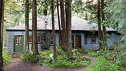
Alderbrook Lodge - Rhododendron Oregon.jpg
The Alderbrook Lodge
USA Oregon location map.svg
Red pog.svg
Rhododendron
Location within the state of Oregon
Usa edcp location map.svg
Red pog.svg
Rhododendron
Rhododendron (the United States)
Coordinates: 45°18′11″N121°52′46″W / 45.30306°N 121.87944°W / 45.30306; -121.87944
Country United States
State Oregon
County Clackamas
Elevation
[1]
2,116 ft (645 m)
Time zone UTC-8 (Pacific (PST))
  Summer (DST) UTC-7 (PDT)
ZIP code
97049
Area code(s) 503 and 971
GNIS feature ID2805458 [1]

Rhododendron is an unincorporated community in Clackamas County, Oregon, United States. It is located within the Mount Hood Corridor, between Government Camp and Zigzag on U.S. Route 26 (a.k.a. the Mount Hood Scenic Byway). [2] It is one of the communities that make up the Villages at Mount Hood.

A post office was established in the area in 1909 and named "Rowe" after Henry S. Rowe, a mayor of Portland, Oregon who was interested in developing the state's scenic attractions. [3] In 1917 the office was renamed "Zig Zag" and shortly thereafter "Zigzag". [3] (The name was later reused for the post office in the current community of Zigzag.) [3] In 1920 the office was renamed "Rhododendron" because of the large number of rhododendrons growing near there. [3] The community started out as a summer resort colony, but with the increased popularity of skiing, it became a year-round settlement. [3]

See also

Related Research Articles

<span class="mw-page-title-main">Mount Hood Village, Oregon</span> Unincorporated community in the state of Oregon, United States

Mount Hood Village is the name of a census-designated place (CDP) within the Mount Hood Corridor in Clackamas County, Oregon, United States. As of the 2010 census, the CDP had a population of 4,864. The Villages at Mount Hood is the name of the combined government of several of the communities encompassed by the CDP and is a separate entity.

<span class="mw-page-title-main">Zigzag, Oregon</span> Unincorporated community in the state of Oregon, United States

Zigzag is an unincorporated community in Clackamas County, Oregon, United States. It is located within the Mount Hood Corridor, between Rhododendron and Welches on U.S. Route 26. The community is part of a local type of government called a village as one of the communities making up the Villages at Mount Hood, which stretches from the border of Sandy to Government Camp.

<span class="mw-page-title-main">Welches, Oregon</span> Unincorporated community in the state of Oregon, United States

Welches is an unincorporated community in Clackamas County, Oregon, United States. It is located within the Mount Hood Corridor between Zigzag and Wemme along U.S. Route 26. It is one of the many communities that make up the Villages at Mount Hood.

<span class="mw-page-title-main">Wemme, Oregon</span> Unincorporated community in the state of Oregon, United States

Wemme is an unincorporated community in the northwest United States, located in Clackamas County, Oregon, east of Portland. It is located within the Mount Hood Corridor, between Welches and Brightwood along U.S. Route 26. It is one of the communities that make up the Villages at Mount Hood.

<span class="mw-page-title-main">Brightwood, Oregon</span> Unincorporated community in the state of Oregon, United States

Brightwood is an unincorporated community within the Mount Hood Corridor in Clackamas County, Oregon, United States. It is located between Wemme and Sandy just off U.S. Route 26 at an elevation of 1165 feet. It is one of the communities that make up the Villages at Mount Hood.

<span class="mw-page-title-main">Sandy River (Oregon)</span> River in Oregon, United States

The Sandy River is a 56-mile (90 km) tributary of the Columbia River in northwestern Oregon in the United States. The Sandy joins the Columbia about 14 miles (23 km) upstream of Portland.

<span class="mw-page-title-main">Mount Hood, Oregon</span> Unincorporated community in the state of Oregon, United States

Mount Hood is an unincorporated community and census-designated place (CDP) in Hood River County, Oregon, United States, about 3 miles (5 km) northeast of Parkdale on Oregon Route 35. As of the 2010 census it had a population of 286. Mount Hood is the terminus of Oregon Route 281, the Hood River Highway.

<span class="mw-page-title-main">Zigzag River</span> River in Oregon, United States

The Zigzag River is a tributary, about 12 miles (19 km) long, of the Sandy River in the U.S. state of Oregon. The Zigzag and one of its major tributaries, the Little Zigzag River, drain the Zigzag Glacier on Mount Hood, a high volcanic peak in the Cascade Range. Their waters flow westward to meet the Sandy River near the community of Zigzag. The river's flow ranges from 200 to 1,000 cubic feet per second.

<span class="mw-page-title-main">Bull Run, Oregon</span> Unincorporated community in the state of Oregon, United States

Bull Run is an unincorporated community in Clackamas County, Oregon, United States. It is located about 5 miles (8.0 km) northeast of Sandy, near the Bull Run River and the powerhouse of the defunct Mount Hood Railway and Power Company.

Cottrell is an unincorporated crossroads community in north Clackamas County, Oregon, United States. It was founded by Georgia Andrews, the wife of Charles Ida Andrews. Georgia and her mother Carrie Arabella (Townsley) Cottrell moved to Oregon from Milwaukee, Wisconsin after Georgia's father and Carrie's husband George Cottrell, was killed in a railroad accident. Georgia typically went by and wrote her name as 'Georgie'. There was a Cottrell post office from 1894 until 1904; it probably closed when Rural Free Delivery was extended to the area. There is also a Cottrell Road and a Cottrell school a mile east of the locale, and there was a Cottrell station on the defunct Mount Hood Electric Railway line about a mile to the north. The now-abandoned station was across the county line in Multnomah County. Georgia and her mother Carrie both died in Ashland, in 1953 and 1943 respectively.

<span class="mw-page-title-main">Tom Dick and Harry Mountain</span> Volcanic mountain in Clackamas County, Oregon, United States

Tom Dick and Harry Mountain is a 2-mile-long (3.2 km) volcanic mountain in Clackamas County in the U.S. state of Oregon. It is located 7.2 miles (11.6 km) southwest of Mount Hood, 1.9 miles (3.1 km) west-southwest of Government Camp between the Zigzag River and Still Creek, south of Zigzag Mountain. Because of its proximity to Mount Hood, it is considered a foothill.

<span class="mw-page-title-main">Valley Falls, Oregon</span> Unincorporated community in the state of Oregon, United States

Valley Falls is a small unincorporated community in Lake County, Oregon, United States. The settled area is located at the junction of U.S. Route 395 and Oregon Route 31. The community is named for a small falls on the Chewaucan River just north of the occupied site. East of Valley Falls, the cliff face of Abert Rim overlooks the community.

London Springs is an unincorporated community in Lane County, Oregon, United States. It lies 11.33 miles (18.23 km) south-southwest of Cottage Grove at an elevation of 896 feet (273 m). London Springs is near the Coast Fork Willamette River, south of Cottage Grove Lake.

<span class="mw-page-title-main">Zigzag Mountain</span> Volcanic mountain in Clackamas County, Oregon, United States

Zigzag Mountain is a volcanic mountain in Clackamas County in the U.S. state of Oregon. It is located 7.1 miles (11.4 km) west-southwest of Mount Hood, 5.2 miles (8.4 km) northwest of Government Camp, 5.3 miles (8.5 km) east of Zigzag, and north of the Zigzag River. Because of its proximity to Mount Hood, it is considered a foothill.

<span class="mw-page-title-main">Little Zigzag River</span> River in Oregon, United States

The Little Zigzag River is a tributary, about 5 miles (8.0 km) long, of the Zigzag River in the U.S. state of Oregon. The Zigzag and Little Zigzag drain the Zigzag Glacier on Mount Hood, a high volcanic peak in the Cascade Range. Their combined waters flow westward to meet the Sandy River near the community of Zigzag. Little Zigzag Falls, a popular hiking destination, is on the river near U.S. Route 26 east of Zigzag.

Wyeth is an unincorporated locale in Hood River County, Oregon, United States. It is the site of a campground area in the Columbia River Gorge National Scenic Area off Interstate 84 (I-84).

Blazed Alder Creek is a tributary, about 4 miles (6 km) long, of the Bull Run River in the U.S. state of Oregon. Part of the system that provides drinking water to the city of Portland, it flows generally north through a protected part of the Mount Hood National Forest in Clackamas and Multnomah counties. The creek is named after a 24-inch (61 cm) blazed (marked) alder tree that was used as a benchmark during early watershed surveys.

Cherryville is an unincorporated community and former town in Clackamas County, Oregon, United States, founded in 1884. It is located approximately 6 miles (9.7 km) east of Sandy on U.S. Route 26, near the route of the Barlow Road.

<span class="mw-page-title-main">Henry S. Rowe</span> American politician

Henry Spoor Rowe was an American businessman and politician. He served as the Mayor of Portland, Oregon, from 1900 to 1902.

Faubion is an unincorporated community in Clackamas County, Oregon, United States. It is located about 2 miles northwest of Rhododendron, in the Mount Hood Corridor on a loop road off U.S. Route 26 near the Zigzag River.

References

  1. 1 2 U.S. Geological Survey Geographic Names Information System: Rhododendron, Oregon
  2. "Rhododendron". Geographic Names Information System . United States Geological Survey, United States Department of the Interior. November 28, 1980. Retrieved August 12, 2011.
  3. 1 2 3 4 5 McArthur, Lewis A.; McArthur, Lewis L. (2003) [1928]. Oregon Geographic Names (7th ed.). Portland, Oregon: Oregon Historical Society Press. p. 807. ISBN   978-0875952772.