Northwest District, Portland, Oregon

Last updated

Northwest District
Neighborhood
NW 23rd at Irving.jpeg
NW 23rd Ave at Irving Street in the Northwest District
Portland map.png
Red pog.svg
Northwest District
Coordinates: 45°31′58″N122°41′55″W / 45.53264°N 122.69872°W / 45.53264; -122.69872 PDF map
Country United States
State Oregon
City Portland
Government
  Association Northwest District Association
  Coalition Neighbors West/Northwest
Area
  Total1.33 sq mi (3.44 km2)
Population
 (2000) [1]
  Total11,455
  Density8,600/sq mi (3,300/km2)
Housing
[1]
  No. of households7,567
  Occupancy rate94% occupied
  Owner-occupied1,137 households (15%)
  Renting6,430 households (85%)
  Avg. household size1.51 persons

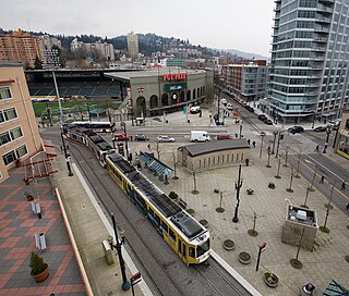
The Northwest District is a densely populated retail and residential neighborhood in the northwest section of Portland, Oregon, United States. Craftsman-style and Old Portland-style houses are packed tightly together with old apartment buildings and new condominiums, within walking distance of restaurants, bars, and shops. The Portland Streetcar's first line (the NS Line) terminates there, connecting the district to the Pearl District, Downtown Portland and points south to the South Waterfront, and several TriMet bus lines also serve the district.

Contents

The district stretches west to east from the base of the West Hills (Tualatin Mountains) to I-405 (between NW 15th and 16th avenues), and north to south from NW Nicolai Street and the Willamette River to W Burnside St. It borders the neighborhoods of Forest Park and Hillside on the west, Northwest Industrial on the north, the Pearl District on the east, and Goose Hollow on the south.

This part of Portland is known more by names for various streets and areas within it than by its official name. These include:
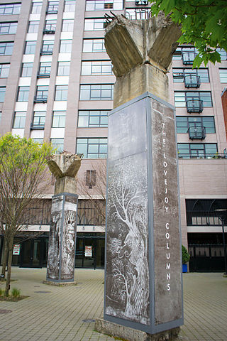
The Alphabet Historic District, a portion of the larger Alphabet District area zoned for historic preservation, extending roughly between NW 17th and 24th Avenues, and between W Burnside and NW Marshall Streets, is listed as a historic district on the National Register of Historic Places. [10] [11]

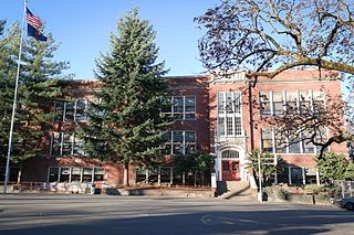
Beyond NW 21st and 23rd are residential districts and recreational areas, such as the forested Macleay Park (acquired 1897, in the Forest Park neighborhood). Parks within the Northwest District include Couch Park (1977) and Wallace Park (1920). Northwest District public schools include Chapman Elementary School and the Metropolitan Learning Center. Legacy Good Samaritan Hospital and Medical Center and Linfield University-Portland Campus are located between NW 23rd and NW 22nd avenues.

Several characters in Portland native Matt Groening's television show The Simpsons have names based on the alphabetically named streets in the Northwest District, e.g. Reverend Lovejoy, Mayor Quimby and the bully Kearney. [12]

See also

Related Research Articles

<span class="mw-page-title-main">Portland, Oregon</span> Largest city in Oregon, United States

Portland is a port city in the Pacific Northwest and the most populous city in the U.S. state of Oregon. Situated in the northwestern area of the state at the confluence of the Willamette and Columbia rivers, Portland is the county seat of Multnomah County, the most populous county in Oregon. As of 2020, Portland had a population of 652,503, making it the 26th-most populated city in the United States, the sixth-most populous on the West Coast, and the second-most populous in the Pacific Northwest, after Seattle. Approximately 2.5 million people live in the Portland–Vancouver–Hillsboro, OR–WA metropolitan statistical area, making it the 25th most populous in the United States. About half of Oregon's population resides within the Portland metropolitan area.

The Pearl District is an area of Portland, Oregon, formerly occupied by warehouses, light industry and railroad classification yards and now noted for its art galleries, upscale businesses and residences. The area has been undergoing significant urban renewal since the mid-1980s when it was reclassified as mixed use from industrial, including the arrival of artists, the removal of a viaduct and construction of the Portland Streetcar. It now consists of industrial building conversion to offices, high-rise condominiums and warehouse-to-loft conversions.

<span class="mw-page-title-main">John H. Couch</span>

John Heard Couch was an American sea captain and pioneer in the Oregon Country in the 19th century. Often referred to as Captain Couch, he became famous for his singular skill at navigation of the Columbia Bar. He was a founder of Portland, Oregon.

<span class="mw-page-title-main">Hawthorne, Portland, Oregon</span> Area of Portland, Oregon, U.S.

The Hawthorne District in Portland, Oregon, is an area of Southeast Portland on SE Hawthorne Blvd. that runs from 12th to 60th Avenues, with the primary core of businesses between 30th and 50th Avenues. The area has numerous retail stores, including clothing shops, restaurants, bars, brewpubs, and microbreweries.

<span class="mw-page-title-main">Transportation in Portland, Oregon</span> Overview of movement of goods and passengers in Portland

Like transportation in the rest of the United States, the primary mode of local transportation in Portland, Oregon is the automobile. Metro, the metropolitan area's regional government, has a regional master plan in which transit-oriented development plays a major role. This approach, part of the new urbanism, promotes mixed-use and high-density development around light rail stops and transit centers, and the investment of the metropolitan area's share of federal tax dollars into multiple modes of transportation. In the United States, this focus is atypical in an era when automobile use led many areas to neglect their core cities in favor of development along interstate highways, in suburbs, and satellite cities.

Portland is "an international pioneer in transit orientated developments."

<span class="mw-page-title-main">Downtown Portland, Oregon</span> Neighborhood in Portland, Oregon, United States

Downtown Portland is the central business district of Portland, Oregon, United States. It is on the west bank of the Willamette River in the northeastern corner of the southwest section of the city and where most of the city's high-rise buildings are found.

<span class="mw-page-title-main">Old Town Chinatown</span> Neighborhood in Portland, Oregon, United States

Old Town Chinatown is the official Chinatown of the northwest section of Portland, Oregon. The Willamette River forms its eastern boundary, separating it from the Lloyd District and the Kerns and Buckman neighborhoods. It includes the Portland Skidmore/Old Town Historic District and the Portland New Chinatown/Japantown Historic District, which are listed on the National Register of Historic Places. It has been referred to as the "skid row" of Portland.

<span class="mw-page-title-main">Buckman, Portland, Oregon</span> Neighborhood in Portland, Oregon, United States

Buckman is a neighborhood in the Southeast section of Portland, Oregon. The neighborhood is bounded by the Willamette River on the west, E Burnside St. on the north, SE 28th Ave. on the east, and SE Hawthorne Blvd. on the south.

<span class="mw-page-title-main">Couch Park</span> Public park in Portland, Oregon, U.S.

Couch Park is a city park in Portland, Oregon, located at the intersection of Northwest 19th Avenue and Glisan Street. Named after merchant John H. Couch, the park was acquired in 1977.

<span class="mw-page-title-main">Providence Park station</span> Light rail station in Portland, Oregon

Providence Park is a light rail station on the MAX Blue and Red lines located in the Goose Hollow neighborhood of Portland, Oregon. It is named after the adjacent stadium, Providence Park. The station primarily serves Providence Park and residential areas around West Burnside Street. The station, consisting of separate eastbound and westbound platforms built into city sidewalks between SW 17th and SW 18th Avenues on SW Yamhill and SW Morrison Streets, opened on August 31, 1997.

<span class="mw-page-title-main">Elephants Delicatessen</span> Delicatessen and catering company based in Portland, Oregon, U.S.

Elephants Delicatessen is a local delicatessen and catering company based in Portland, Oregon, in the United States, established in 1979. Its flagship store is located on Northwest 22nd Avenue.

<span class="mw-page-title-main">Burnside Street</span> Street in Portland, Oregon, U.S.

Burnside Street is a major thoroughfare of Portland, in the U.S. state of Oregon, and one of a few east–west streets that runs uninterrupted on both sides of the Willamette River. It serves as the dividing line between North Portland and South Portland. Its namesake bridge, Burnside Bridge, is one of the most heavily traversed in Portland. In Gresham between approximately the east 18300 block to Mt. Hood Hwy, Burnside runs southeast–northwest and is no longer the divide between northeast and southeast on the City of Portland-Multnomah County street grid. Additionally, SE Burnside St becomes NW Burnside Road at SE 202nd/NW Birdsdale Ave, and NE Burnside Rd at N Main Ave in Gresham. Burnside Road's eastern terminus is where it meets Mt. Hood Hwy (US-26), E Powell Blvd (US-26), and SE Powell Valley Road.

<span class="mw-page-title-main">Alphabet Historic District</span> Historic district in Oregon, United States

The Alphabet Historic District, is a historic district in the Northwest District of Portland, Oregon which was listed on the National Register of Historic Places in 2000. It is 156.9 acres (63.5 ha) in area and includes 478 contributing buildings. It is roughly bounded by NW Lovejoy St., NW Marshall St., NW 17th Ave., W. Burnside St., and NW 24th Ave.

<span class="mw-page-title-main">LGBT culture in Portland, Oregon</span>

LGBT culture in Portland, Oregon is an important part of Pacific Northwest culture.

<i>Lovejoy Columns</i> Columns with murals in Portland, Oregon

The Lovejoy Columns, located in Portland, Oregon, United States, supported the Lovejoy Ramp, a viaduct that from 1927 to 1999 carried the western approach to the Broadway Bridge over the freight tracks in what is now the Pearl District. The columns were painted by Greek immigrant Tom Stefopoulos between 1948 and 1952. In 1999, the viaduct was demolished but the columns were spared due to the efforts of the architectural group Rigga. For the next five years, attempts to restore the columns were unsuccessful and they remained in storage beneath the Fremont Bridge.

<span class="mw-page-title-main">Cornell Road</span> Street in Portland and Washington County, Oregon, United States

Cornell Road is an east–west street and traffic corridor in the Portland metropolitan area, in Multnomah and Washington counties in the U.S. state of Oregon. It crosses the Tualatin Mountains between the Willamette Valley and the city of Portland on the east and the Tualatin Valley and the city of Hillsboro on the west.

<span class="mw-page-title-main">2016 Portland gas explosion</span> Gas explosion

A large natural gas explosion occurred in the Northwest District of Portland, Oregon, USA, at NW 23rd Avenue and NW Glisan Street on October 19, 2016. Nearby excavation caused a natural gas leak that triggered the explosion, which injured eight people and caused $17.2 million in property damages. The PUC determined the cause to be inadequate notification by the contractor, Loy Clark Pipeline. Thirteen buildings were damaged, including total destruction of the Alfred C.F. Burkhardt House, built in 1906 and listed on the NRHP.

<span class="mw-page-title-main">Grassa (restaurant)</span> Restaurant chain in the Portland, Oregon metropolitan area

Grassa is a restaurant with multiple locations in the Portland, Oregon metropolitan area, in the United States. The original restaurant opened in Southwest Portland in 2013; subsequent locations have opened in Northwest Portland's Northwest District, in Southeast Portland's Buckman neighborhood, and in Vancouver, Washington.

Northwest Portland is one of the sextants of Portland, Oregon, United States.

<span class="mw-page-title-main">Portland New Chinatown/Japantown Historic District</span> Historic district in Portland, Oregon, U.S.

The Portland New Chinatown/Japantown Historic District is a historic district in Portland, Oregon's Old Town Chinatown neighborhood, in the United States. The district is listed on the National Register of Historic Places.

References

  1. 1 2 Demographics (2000)
  2. "Portland's NW 23rd Avenue". www.viamagazine.com. Archived from the original on October 28, 2004.
  3. Carlin, Peter Ames (December 24, 2010). "Terry Currier and Music Millennium: The growth, and near-death, of a Portland icon". The Oregonian . Retrieved February 6, 2011.
  4. "Neighborhood Briefs". Portland Tribune . August 21, 2007. Archived from the original on April 24, 2016. Retrieved September 21, 2014.
  5. Chemotti, Lucas (September 6, 2015). "Buy PDX: The New Tender Loving Empire on NW 23rd". Willamette Week . Retrieved October 29, 2016.
  6. Adams, Anne (April 27, 2010). "PDX monthly: Tender Loving Empire". Portland Monthly . Retrieved April 13, 2016.
  7. "NW Portland explosion: What you need to know". The Oregonian (OregonLive.com). October 21, 2016. Retrieved October 29, 2016.
  8. "Historic Alphabet District: Community Design Guidelines Addendum". PortlandOregon.gov. Bureau Of Planning Portland, Oregon. September 5, 2000. Archived from the original on August 24, 2016. Retrieved June 7, 2016.
  9. "Alphabet District Street Names".
  10. City of Portland, PortlandMaps , retrieved May 18, 2014.
  11. "Oregon National Register List" (PDF). Oregon Parks and Recreation Department. June 6, 2011. p. 29. Archived from the original (PDF) on June 9, 2011. Retrieved June 20, 2011.
  12. Carroll, Larry (July 26, 2007). "'Simpsons' Trivia, From Swearing Lisa To 'Burns-Sexual' Smithers". MTV. Archived from the original on December 18, 2007. Retrieved August 17, 2007.