Eastmoreland is an early-twentieth century, tree-filled neighborhood in inner southeast Portland, Oregon, United States. Eastmoreland was named for a local real estate developer, Judge J.C. Moreland.

The Hawthorne District in Portland, Oregon, is an area of Southeast Portland on SE Hawthorne Blvd. that runs from 12th to 60th Avenues, with the primary core of businesses between 30th and 50th Avenues. The area has numerous retail stores, including clothing shops, restaurants, bars, brewpubs, and microbreweries.

Mount Tabor is the name of a volcanic cinder cone, the city park on the volcano, and the neighborhood of Southeast Portland that surrounds it, all in the U.S. state of Oregon. The name refers to Mount Tabor, Israel. It was named by Plympton Kelly, son of Oregon City pioneer resident Clinton Kelly.
Germantown is a neighborhood three miles southeast of downtown Louisville, Kentucky, USA. Germantown is also a general term for an area of Louisville from the Original Highlands to St Joseph and Bradley neighborhoods that were predominantly settled by Germans. The actual neighborhood is bounded by Barrett Ave, Eastern Parkway, and the South Fork of Beargrass Creek.

Hillcrest is a residential neighborhood in the southeast quadrant of Washington, D.C., United States. Hillcrest is located on the District-Maryland line in Ward 7, east of the Anacostia River.

Woodstock is a neighborhood located in inner southeast Portland, Oregon, United States.
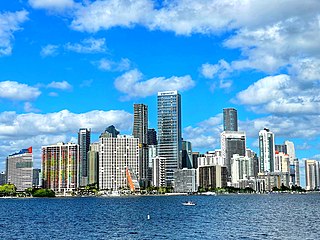
Brickell is a neighborhood in Miami, Florida, historically referenced at times as Southside, located directly east of Interstate 95, south of the Miami River, and north of Coconut Grove. Brickell is known as the financial district of Miami, as well as South Florida.

Ardenwald-Johnson Creek is a neighborhood straddling the border between Portland and Milwaukie, Oregon. It is recognized by both Portland's Office of Neighborhood Involvement as well as Milwaukie's Neighborhoods Program.
The Beaumont-Wilshire neighborhood of Portland, Oregon is located in the city's northeast section, on Alameda Ridge with views of Downtown, the Willamette River, and the Cascades. It is bordered by the Alameda, Concordia, Cully, Rose City Park, and Grant Park neighborhoods. "Beaumont Village", located on NE Fremont Street, from NE 33rd Ave. to NE 50th Ave., is the main commercial district in the neighborhood, but the neighborhood also lies within walking distance of the Hollywood District, a major commercial and shopping area to the south.

Sunnyside is a neighborhood in the south east section of Portland, between SE Stark Street and SE Hawthorne Blvd. and from SE 28th Ave. to SE 49th Ave.. The Sunnyside Neighborhood motto is "Proud Past, Bright Future". Sunnyside has a "strong sense of Portland individuality" with many locally owned coffee shops and businesses. Sunnyside is bordered by Laurelhurst to the north, Richmond to the south, Buckman to the west, and Mount Tabor to the east. Because of its Victorian architecture and bohemian culture, Hawthorne/Belmont is often compared to San Francisco's Haight Ashbury district. Sunnyside has been called Portland's "uncontested champion of eco-consciousness".

Buckman is a neighborhood in the Southeast section of Portland, Oregon. The neighborhood is bounded by the Willamette River on the west, E Burnside St. on the north, SE 28th Ave. on the east, and SE Hawthorne Blvd. on the south.

The Lents neighborhood in the Southeast section of Portland, Oregon is bordered by SE Powell Blvd. on the north, the Clackamas County line or City of Portland line on the south, SE 82nd Ave. to the west, and roughly SE 112th on the east. The NE corner overlaps with the Powellhurst-Gilbert neighborhood. In addition to Powellhurst-Gilbert on the north and east, Lents also borders Foster-Powell, Mt. Scott-Arleta, and Brentwood-Darlington on the west and Pleasant Valley on the east.
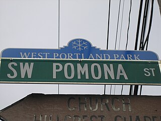
West Portland Park is a neighborhood in the Southwest section of Portland, Oregon. It lies between SW 53rd Ave. in the west and SW 35th Ave. in the east, and I-5 in the north and SW Stephenson St. in the south. South of SW Pomona St., the western border is SW 49th Ave. The neighborhood borders Crestwood and Far Southwest to the west, Multnomah to the north, Markham and Arnold Creek to the east, and the city of Lake Oswego to the south.

Creston-Kenilworth is a neighborhood in the Southeast section of Portland, Oregon, lying between SE 26th Ave. on the west and SE Foster Rd. on the east, and between SE Powell Blvd. on the north and SE Holgate Blvd. on the south. It is adjacent to the neighborhoods of Brooklyn to the west, Hosford-Abernethy, and Richmond to the north, Foster-Powell and Mt. Scott-Arleta to the east, and Reed and Woodstock to the south.
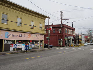
The Belmont Area is a retail and residential district running along SE Belmont St. in the inner Southeast section of Portland, Oregon in a parallel fashion to the Hawthorne District, 6 blocks to the south. From west to east the area extends 48 blocks, from SE 12th Ave. to SE 60th Ave., passing through the Buckman, Sunnyside, and Mount Tabor neighborhoods. The area is seven blocks wide, running from SE Belmont St. 4 blocks north to SE Stark St. and 3 blocks south to SE Salmon St. SE Belmont St. between SE 33rd Ave. and SE 35th Ave., in Sunnyside, is the heart of the district.
The Mt. Scott-Arleta neighborhood of Portland, Oregon is located in the city's southeast quadrant. It is bounded on the north by SE Foster Road, west by SE 60th Avenue, east by SE 82nd Avenue, and south by SE Duke. Mt. Scott-Arleta borders the neighborhoods of Woodstock on the west, Foster-Powell on the north, Lents on the east, and Brentwood-Darlington on the south.

Randle Highlands is a neighborhood in Southeast Washington, D.C., east of the Anacostia River.
Montavilla is a neighborhood in the Northeast and Southeast sections of Portland, Oregon, United States, and contains an area east of Mount Tabor and west of Interstate 205, from the Banfield to SE Division. It is bordered by North Tabor, Mount Tabor, South Tabor, Madison South, Hazelwood, and Powellhurst-Gilbert.

Martin Luther King Jr. Avenue is a major street in the District of Columbia traversing through both the Southwest and Southeast quadrants.

Southeast Bybee Boulevard is a light rail station in Portland, Oregon, United States, served by TriMet as part of the MAX Light Rail system. It is the 14th station southbound on the Orange Line, which operates between Portland City Center, Southeast Portland, and Milwaukie. The grade-separated, island platform station adjoins Union Pacific Railroad (UP) freight tracks to the east and McLoughlin Boulevard to the west. Its entrances are located on the Bybee Bridge, which spans over the platform and connects Portland's Sellwood-Moreland and Eastmoreland neighborhoods. Nearby places of interest include Westmoreland Park, Eastmoreland Golf Course, Crystal Springs Rhododendron Garden, and Reed College.

