
Portland is the most populous city in the U.S. state of Oregon, located in the Pacific Northwest region. Situated in the northwestern area of the state at the confluence of the Willamette and Columbia rivers, it is the county seat of Multnomah County, Oregon's most populous county. As of 2020, Portland's population was 652,503, making it the 26th-most populous city in the United States, the sixth-most populous on the West Coast, and the second-most populous in the Pacific Northwest, after Seattle. Approximately 2.5 million people live in the Portland metropolitan area, making it the 25th-most populous in the United States. About half of Oregon's population resides within the Portland metro area.

Forest Park is a public municipal park in the Tualatin Mountains west of downtown Portland, Oregon, United States. Stretching for more than 8 miles (13 km) on hillsides overlooking the Willamette River, it is one of the country's largest urban forest reserves. The park, a major component of a regional system of parks and trails, covers more than 5,100 acres (2,064 ha) of mostly second-growth forest with a few patches of old growth. More than 80 miles (130 km) of recreational trails, including the Wildwood Trail segment of the city's 40-Mile Loop system, crisscross the park.

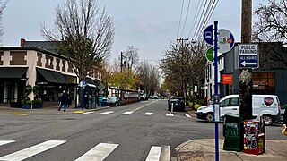
St. Johns is a neighborhood of Portland, Oregon, United States, located in North Portland on the tip of the peninsula formed by the confluence of the Willamette River and the Columbia River. The iconic St. Johns Bridge crosses the Willamette from the south, leading into downtown St. Johns. It was a separate, incorporated city from 1902 until 1915, when citizens of both St. Johns and Portland voted to approve its annexation to Portland, which took effect on July 8, 1915.
Kenton is a neighborhood in the north section of Portland, Oregon, United States. The neighborhood was originally a company town founded in 1911 for the Swift Meat Packing Company.
The Northwest District is a densely populated retail and residential neighborhood in the northwest section of Portland, Oregon, United States. Craftsman-style and Old Portland-style houses are packed tightly together with old apartment buildings and new condominiums, within walking distance of restaurants, bars, and shops. The Portland Streetcar's first line terminates there, connecting the district to the Pearl District, Downtown Portland and points south to the South Waterfront, and several TriMet bus lines also serve the district.

Albina is a historical American city that was consolidated into Portland, Oregon in 1891.

Sullivan's Gulch is a neighborhood in the Northeast section of Portland, Oregon. The name commemorates Timothy Sullivan, an early farmer in the area. Sullivan settled his donation land claim on January 27, 1851. He was born in Ireland in 1805, received citizenship in the United States in 1855, and most likely received title to the claim around 1863.
Portsmouth is a neighborhood in the north section of Portland, Oregon, United States. It is bordered by Columbia Boulevard to the north, Lombard Street to the south, Chautauqua Boulevard to the east, and a BNSF Railway cut to the west.

Portland University was a private, Methodist post-secondary school in Portland, Oregon, United States. Founded in 1891 in a split from Willamette University, the school closed in 1900. The campus was located in what is now the University Park neighborhood and later became home of the University of Portland. The original campus building, West Hall, still stands and is listed on the National Register of Historic Places.
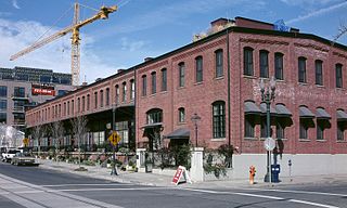
The North Bank Depot Buildings, in central Portland, Oregon, United States, are a pair of buildings formerly used as a freight warehouse and passenger terminal for the Spokane, Portland and Seattle Railway (SP&S). Formed in 1905, the SP&S was commonly known as the North Bank Road during the period in which these buildings were in use. The Portland buildings' passenger facilities were also used by the Oregon Electric Railway after that railway was acquired by the SP&S. Located in what is now known as the Pearl District, the buildings were listed on the National Register of Historic Places in 1996. They were in use by the SP&S and its successor, Burlington Northern Railroad, from 1908 until the 1980s. Only the east building was used as a passenger station, and this usage lasted from 1908 until 1931.

Povey Brothers Studio, also known as Povey Brothers Art Glass Works or Povey Bros. Glass Co., was an American producer of stained glass windows based in Portland, Oregon. The studio was active from 1888 to 1928. As the largest and best known art glass company in Oregon, it produced windows for homes, churches, and commercial buildings throughout the West. When the firm was founded in 1888, it was the only creative window firm in Portland, then a city of 42,000 residents.

Stephen Coffin was an investor, promoter, builder, and militia officer in mid-19th century Portland in the U.S. state of Oregon. Born in Maine, he moved to Oregon City in 1847, and in 1849 he bought a half-interest in the original Portland townsite.

The People's Transportation Company operated steamboats on the Willamette River and its tributaries, the Yamhill and Tualatin rivers, in the State of Oregon from 1862 to 1871. For a brief time this company operated steamers on the Columbia River, and for about two months in 1864, the company operated a small steamer on the Clackamas River.

Alice was a stern-wheel driven steamboat that operated on the Willamette and Columbia rivers in the 1870s and 1880s. Alice was the largest vessel built above Willamette Falls and was considered in its day to be the "Queen of the River". This steamer was rebuilt after near-destruction in a fire at Oregon City, Oregon in May 1873. In 1876, it was withdrawn from the upper Willamette River and transferred to the Columbia River, where it was worked as a towboat moving ocean-going ships to and from Portland and Astoria, Oregon, near the mouth of the Columbia River.

Albany was a stern-wheel driven steamboat that operated on the Willamette River from 1868 to 1875. This vessel should not be confused with the later sternwheeler Albany, which ran, also on the Willamette River, from 1896 to 1906, when it was rebuilt and renamed Georgie Burton.

Jessie Harkins was a propeller-driven steamboat that operated on the Columbia River in the USA starting in 1903. It was rebuilt at least twice. Originally, Jessie Harkins was one of the larger gasoline-engined vessels to operate on the Columbia River. Jessie Harkins was built for the Harkins Transportation Company.

Joseph Kellogg was a stern-wheel driven steamboat that operated on the Willamette, Columbia, and Cowlitz rivers for the Kellogg Transportation Company. It was named after the company's founder, Joseph Kellogg (1812-1903). The sternwheeler Joseph Kellogg was built in 1881 at Portland, Oregon.

New Columbia is a housing development in the Portsmouth neighborhood of Portland, Oregon. It was previously called Columbia Villa. It is operated by the city's public housing authority, Home Forward, and is the largest public housing development in the state.

Undine was a sternwheel-driven steamboat that operated from 1887 to 1935 on the Columbia and lower Willamette rivers. From 1935 to 1940 the same vessel was operated under the name The Dalles.
The following is a timeline of the history of Oregon in the United States of America.


