Eastmoreland is an early-twentieth century, tree-filled neighborhood in inner southeast Portland, Oregon, United States. Eastmoreland was named for a local real estate developer, Judge J.C. Moreland.

Larchmont is a half-square-mile neighborhood in the central region of the City of Los Angeles, California. It has three schools and one small park. It has been the site of early and recent motion picture shoots.

Rosa Parks is a light rail station on the MAX Yellow Line in the Arbor Lodge neighborhood of Portland, Oregon. It is the 6th stop northbound on the Interstate MAX extension. It was originally named North Portland Boulevard, but following the city's decision in fall 2006 to rename Portland Blvd. to Rosa Parks Way, TriMet indicated it would support the change by renaming the station, at a then-undetermined future date. The signs at the station continued to show the old name until Feb. 4, 2009, when a dedication ceremony was held, unveiling new signs renaming it as "Rosa Parks" station. On TriMet's maps and other media, the station is shown as "N Rosa Parks Way".
Kenton is a neighborhood in the north section of Portland, Oregon, United States. The neighborhood was originally a company town founded in 1911 for the Swift Meat Packing Company.
South Portland is a long, narrow neighborhood just south of Downtown Portland, Oregon, hemmed in between the Willamette River and the West Hills. It stretches from I-405 and the Marquam Bridge on the north, to SW Canby St. and the Sellwood Bridge in the south. The Willamette forms the eastern boundary, and SW Barbur Blvd. most of the western boundary. In addition to Downtown to the north, other bordering neighborhoods are Southwest Hills, Homestead, Hillsdale, and South Burlingame to the west, and Hosford-Abernethy, Brooklyn, and Sellwood-Moreland across the river on the east.

Mid-City West is a area in the western part of Central Los Angeles that is served by the Mid City West Neighborhood Council. It contains the neighborhoods of Beverly–Fairfax, Beverly Grove, Burton Way, Carthay Circle, Melrose, Miracle Mile and Park La Brea.

Buckman is a neighborhood in the Southeast section of Portland, Oregon. The neighborhood is bounded by the Willamette River on the west, E Burnside St. on the north, SE 28th Ave. on the east, and SE Hawthorne Blvd. on the south.
North Tabor Neighborhood in Portland, Oregon, United States, is on the east side of the Willamette River on the northern slope of Mount Tabor. The Banfield Expressway forms its northern boundary, separating it from the Hollywood District, Rose City Park, and Madison South neighborhoods to the north. NE/SE 44th Avenue separates it from Laurelhurst to the west while NE 68th Avenue separates it from Montavilla to the east. East Burnside Street forms most of the southern boundary, except for a section west of SE 49th Avenue for which SE Stark Street forms the boundary with the Sunnyside neighborhood.
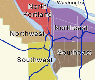
Portland, Oregon is divided into six sections: North Portland, Northeast Portland, Northwest Portland, South Portland, Southeast Portland, and Southwest Portland. There are 95 officially recognized neighborhoods, each of which is represented by a volunteer-based neighborhood association. No neighborhood associations overlap the Willamette River, but a few overlap the addressing sextants. For example, most addresses in the South Portland Neighborhood Association are South, but a portion of the neighborhood is west of SW View Point Terrace where addresses have a SW prefix. Similarly the Buckman Neighborhood Association spans both NE and SE Portland.
South Burlingame is a neighborhood in the Southwest section of Portland, Oregon. It is bordered by Multnomah to the west, Hillsdale and South Portland to the north, the River View Cemetery to the east, and Markham, Marshall Park, and Collins View to the south.
Overlook is a neighborhood in the North section of Portland, Oregon on the east shore of the Willamette River. It borders University Park and Arbor Lodge on the north, Humboldt and Boise on the east, Eliot on the southeast, and Northwest Industrial and the Northwest District across the Willamette on the west.
Portsmouth is a neighborhood in the north section of Portland, Oregon, United States. It is bordered by Columbia Boulevard to the north, Lombard Street to the south, Chautauqua Boulevard to the east, and a BNSF Railway cut to the west.
University Park is a neighborhood in the north section of Portland, Oregon on the east shore of the Willamette River. University Park is bounded by North Lombard Street and the Portsmouth neighborhood to the north, North Chautauqua Boulevard and the Arbor Lodge neighborhood to the east, The Willamette River and Mock's Bottom industrial area to the south, and the North Portland railroad cut with Cathedral Park and St. Johns neighborhoods to the west.
Montavilla is a neighborhood in the Northeast and Southeast sections of Portland, Oregon, United States, and contains an area east of Mount Tabor and west of Interstate 205, from the Banfield to SE Division. It is bordered by North Tabor, Mount Tabor, South Tabor, Madison South, Hazelwood, and Powellhurst-Gilbert.

The neighborhoods of Albany, New York are listed below.
Portland, Maine, is home to many neighborhoods.

Hollins Market is a neighborhood in the Sowebo area of Baltimore. It takes its name from the Hollins Market, the oldest public market building still in use in Baltimore City, which is located in the heart of the neighborhood.

Lombard Street is a main thoroughfare in North and Northeast Portland, Oregon. It serves as a boundary and main commercial street for several North Portland neighborhoods.


