
The Hawthorne District in Portland, Oregon, is an area of Southeast Portland on SE Hawthorne Blvd. that runs from 12th to 60th Avenues, with the primary core of businesses between 30th and 50th Avenues. The area has numerous retail stores, including clothing shops, restaurants, bars, brewpubs, and microbreweries.

West Garfield Park on the West Side of Chicago, Illinois, is one of 77 officially designated Chicago community areas. It is directly west of Garfield Park.

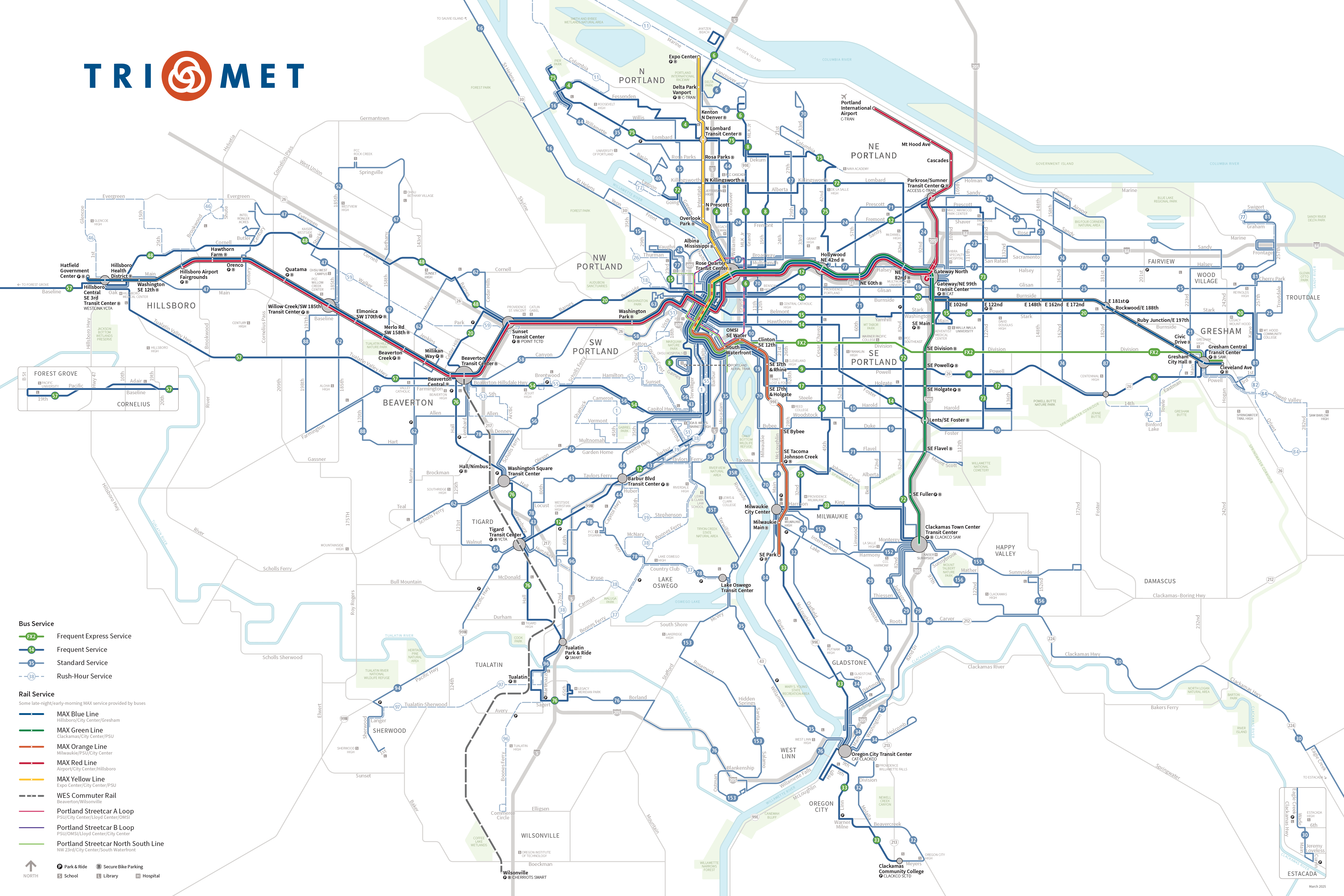
The MAX Yellow Line is a light rail line serving Portland, Oregon, United States. Operated by TriMet as part of the MAX Light Rail system, it connects North Portland, Portland City Center, and Portland State University (PSU). The line serves 17 stations; it runs north–south from Expo Center station to PSU South/Southwest 6th and College station, interlining with the Green and Orange lines within the Portland Transit Mall. Service runs for 21 hours per day with headways of up to 15 minutes. The Yellow Line is the fourth-busiest service in the MAX system; it carried an average 12,960 riders per weekday in September 2019.
Kenton is a neighborhood in the north section of Portland, Oregon, United States. The neighborhood was originally a company town founded in 1911 for the Swift Meat Packing Company.
The western border of Santa Monica, California, is the 3-mile (4.8 km) stretch of Santa Monica Bay. On its other sides, the city is bordered by various districts of Los Angeles: the northwestern border is Pacific Palisades, the eastern border is Brentwood north of Wilshire Boulevard and West Los Angeles south of Wilshire, the northeastern border is generally San Vicente Boulevard up to the Riviera Country Club, the southwestern border is Venice Beach and the southern border is with West Los Angeles and Mar Vista.

Albina is a historical American city that was consolidated into Portland, Oregon in 1891.

Arbor Lodge is a neighborhood in the North section of Portland, Oregon. Interstate 5 forms the eastern boundary of the neighborhood. The south boundary is formed by Ainsworth Street, the west boundary is formed by a combination of Willamette Boulevard and Chataqua Boulevard, and the north boundary is formed by Lombard Street. The bordering neighborhoods are Piedmont to the east, Overlook to the south, University Park to the west, and Kenton to the north.

Buckman is a neighborhood in the Southeast section of Portland, Oregon. The neighborhood is bounded by the Willamette River on the west, E Burnside St. on the north, SE 28th Ave. on the east, and SE Hawthorne Blvd. on the south.

The Lents neighborhood in the Southeast section of Portland, Oregon is bordered by SE Powell Blvd. on the north, the Clackamas County line or City of Portland line on the south, SE 82nd Ave. to the west, and roughly SE 112th on the east. The NE corner overlaps with the Powellhurst-Gilbert neighborhood. In addition to Powellhurst-Gilbert on the north and east, Lents also borders Foster-Powell, Mt. Scott-Arleta, and Brentwood-Darlington on the west and Pleasant Valley on the east.

Wilkes is the northeasternmost neighborhood in Portland, Oregon, bordered on the north by the Columbia River and on the east by the city of Gresham, where it expands into the city as the neighborhood of Wilkes East. It adjoins the neighborhoods of Argay, Russell, and Hazelwood on the west, and Glenfair on the south. Interstate 84 runs through the middle of the neighborhood.

Rose City Park is a neighborhood in Northeast Portland, Oregon. It borders Beaumont-Wilshire, Grant Park, and the Hollywood District on the west, Cully on the north, Roseway and Madison South on the east, and Center on the south.
Portsmouth is a neighborhood in the north section of Portland, Oregon, United States. It is bordered by Columbia Boulevard to the north, Lombard Street to the south, Chautauqua Boulevard to the east, and a BNSF Railway cut to the west.
University Park is a neighborhood in the north section of Portland, Oregon, United States, on the east shore of the Willamette River. University Park is bounded by North Lombard Street and the Portsmouth neighborhood to the north, North Chautauqua Boulevard and the Arbor Lodge neighborhood to the east, The Willamette River and Mock's Bottom industrial area to the south, and the North Portland railroad cut with Cathedral Park and St. Johns neighborhoods to the west.

Madison South is a neighborhood in the Northeast section of Portland, Oregon. It is bordered by the Roseway, Sumner, Cully, Parkrose, Montavilla, and Rose City Park neighborhoods, and by the enclave city of Maywood Park. The neighborhood roughly conforms to the boundaries of Interstate 84 to the south, Interstate 205 to the east, NE Sandy Boulevard to the north, and NE 65th Avenue to the west.
Parkrose is a neighborhood in the Northeast section of Portland, Oregon, and is considered part of East Portland. It is bordered by Sumner to the west, the Columbia River to the north, Argay to the east, and Parkrose Heights and the city of Maywood Park to the south. Sandy Boulevard crosses the neighborhood, with a primarily industrial area prevailing to the north and primarily residential area to the south.

Foster-Powell is a neighborhood in the Southeast section of Portland, Oregon. The triangular neighborhood is bounded by three major transit arteries: Powell Boulevard to the north, Foster Road to the south, and 82nd Avenue to the east.
Montavilla is a neighborhood in the Northeast and Southeast sections of Portland, Oregon, United States, and contains an area east of Mount Tabor and west of Interstate 205, from the Banfield to SE Division. It is bordered by North Tabor, Mount Tabor, South Tabor, Madison South, Hazelwood, and Powellhurst-Gilbert.
Waite Park is a neighborhood in the Northeast community in Minneapolis, Minnesota. Its boundaries are 37th Avenue NE to the north, NE Stinson Boulevard to the East, Saint Anthony Parkway to the south, and NE Central Avenue to the west. It is the furthest northeast neighborhood within Minneapolis. It is one of ten neighborhoods in Ward 1 of Minneapolis, currently represented by Council President Elliott Payne, and falls under the jurisdiction of the second precinct of the Minneapolis Police Department.

82nd Avenue of the Roses is a street in Portland, Oregon, and comprises the northern end of Oregon Route 213, also known as the Cascade Highway. It is one of the longest streets in Portland, running down the entire east side of the city, and extending into suburbs to the south.


