
Oregon Route 10 is an Oregon state highway which serves Portland and some of its western suburbs.
Oregon Route 217 is an Oregon state highway which serves the western suburbs of Portland. OR 217 is a controlled-access highway which connects U.S. Route 26 with Interstate 5.
Interstate 405 is a short Interstate Highway in Portland, Oregon. It forms a loop that travels around Downtown Portland west of the Willamette River, between two junctions with I-5 at the Marquam Bridge and Fremont Bridge.

Goose Hollow/Southwest Jefferson Street is a light rail station on the MAX Blue and Red Lines in the Goose Hollow neighborhood of Portland, Oregon. It is the third stop westbound on the Westside MAX alignment and makes several cameo appearances in the movie What the Bleep Do We Know!? as the stop where Marlee Matlin's character boards the train to get into town.

Like transportation in the rest of the United States, the primary mode of local transportation in Portland, Oregon is the automobile. Metro, the metropolitan area's regional government, has a regional master plan in which transit-oriented development plays a major role. This approach, part of the new urbanism, promotes mixed-use and high-density development around light rail stops and transit centers, and the investment of the metropolitan area's share of federal tax dollars into multiple modes of transportation. In the United States, this focus is atypical in an era when automobile use led many areas to neglect their core cities in favor of development along interstate highways, in suburbs, and satellite cities.
Portland is "an international pioneer in transit orientated developments."

Downtown Portland is the city center of Portland, Oregon, United States. It is on the west bank of the Willamette River in the northeastern corner of the southwest section of the city and where most of the city's high-rise buildings are found.

Oregon Route 43 is an Oregon state highway that runs between the cities of Oregon City and Portland, mostly along the western flank of the Willamette River. While it is technically known by the Oregon Department of Transportation as the Oswego Highway No. 3, on maps it is referred to by its route number or by the various street names it has been given.
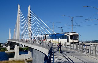
The MAX Orange Line is a light rail service in Portland, Oregon, United States, operated by TriMet as part of the MAX Light Rail system. It connects Portland City Center to Portland State University (PSU), Southeast Portland, Milwaukie, and Oak Grove. The service starts near Portland Union Station and runs southbound only within downtown Portland along the Portland Transit Mall on 5th Avenue. From there, it operates the 7.3-mile (11.7 km) Portland–Milwaukie Light Rail segment through the South Waterfront, across the Willamette River into Southeast Portland, then south to Oak Grove, just outside Milwaukie proper in unincorporated Clackamas County. The line serves 17 stations between Union Station/Northwest 5th & Glisan and Southeast Park Avenue and runs for 201⁄2 hours daily with a minimum headway of 15 minutes during most of the day.

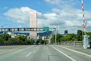
Harbor Drive is a short roadway in Portland, Oregon, functioning mainly as a ramp to and from Interstate 5. It was once much longer, running along the western edge of the Willamette River in the downtown area. Most of the road was replaced with Tom McCall Waterfront Park in the 1970s. Signed as U.S. Route 99W, it had been the major route through the city and its removal is often cited as the first instance of freeway removal in the US and as a milestone in urban planning.

South Portland is a long, narrow neighborhood just south of Downtown Portland, Oregon, hemmed in between the Willamette River and the West Hills. It stretches from I-405 and the Marquam Bridge on the north, to SW Canby St. and the Sellwood Bridge in the south. The Willamette forms the eastern boundary, and SW Barbur Blvd. most of the western boundary. In addition to Downtown to the north, other bordering neighborhoods are Southwest Hills, Homestead, Hillsdale, and South Burlingame to the west, and Hosford-Abernethy, Brooklyn, and Sellwood-Moreland across the river on the east.
Homestead is a Southwest Portland, Oregon, United States, neighborhood in the city's West Hills. The neighborhood is home to Marquam Nature Park, which offers urban hiking in the form of the Marquam Trail, which one can follow to Downtown. The neighborhood also features a scenic boulevard, SW Terwilliger Blvd. Parkway. The parkway has a wide, paved path for walking, running and biking.
Southwest Hills is a neighborhood in the West Hills in the southwest section of Portland, Oregon, United States. The northeastern part of the neighborhood, above Goose Hollow and Downtown Portland, is known as Portland Heights. Much of the western portion of the neighborhood lies outside the Portland city limits, in unincorporated Multnomah County.
Interstate 5 (I-5) in the U.S. state of Oregon is a major Interstate Highway that traverses the state from north to south. It travels to the west of the Cascade Mountains, connecting Portland to Salem, Eugene, Medford, and other major cities in the Willamette Valley and across the northern Siskiyou Mountains. The highway runs 308 miles (496 km) from the California state line near Ashland to the Washington state line in northern Portland, forming the central part of Interstate 5's route between Mexico and Canada.

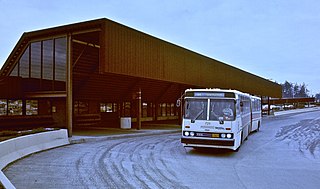
Tigard Transit Center, formally known as Thomas M. Brian Tigard Transit Center, is a transport hub in Tigard, Oregon, United States, that is owned and operated by TriMet. It is a transfer facility for bus routes mainly serving the westside communities of the Portland metropolitan area and the third southbound station from Beaverton Transit Center on WES Commuter Rail. The transit center is the located in downtown Tigard just south of Oregon Route 99W on Commercial Street. It recorded 1,627 average weekday boardings in fall 2019. The facility opened in 1988 as a bus transit center, and a platform for WES was added in 2009.
Burnside Street is a major thoroughfare of Portland, in the U.S. state of Oregon, and one of a few east–west streets that run uninterrupted on both sides of the Willamette River. It serves as the dividing line between North Portland and South Portland. Its namesake bridge, Burnside Bridge, is one of the most heavily traversed in Portland. In Gresham between approximately the east 18300 block to Mt. Hood Hwy, Burnside runs southeast–northwest and is no longer the divide between northeast and southeast on the City of Portland-Multnomah County street grid. Additionally, SE Burnside St becomes NW Burnside Road at SE 202nd/NW Birdsdale Ave, and NE Burnside Rd at N Main Ave in Gresham. Burnside Road's eastern terminus is where it meets Mt. Hood Hwy (US-26), E Powell Blvd (US-26), and SE Powell Valley Road.
The Barbur Boulevard Transit Center is a TriMet transit center located at 9750 SW Barbur Boulevard, near the intersection with Capitol Highway in southwest Portland, Oregon. Barbur TC is proposed to be a future stop on the MAX Green Line as part of the SW Corridor MAX Project, which would extend the Green Line from its current terminus at the PSU South stations southward to Bridgeport Village in Tualatin.

James Terwilliger was an Oregon pioneer and one of the first residents of Portland, Oregon. He is the namesake of Portland's Terwilliger Boulevard and Terwilliger School.

Cornell Road is an east–west street and traffic corridor in the Portland metropolitan area, in Multnomah and Washington counties in the U.S. state of Oregon. It crosses the Tualatin Mountains between the Willamette Valley and the city of Portland on the east and the Tualatin Valley and the city of Hillsboro on the west.

Naito Parkway is a major thoroughfare of Portland in the U.S. state of Oregon. It was formerly known as Front Avenue and Front Street and was renamed in 1996 to honor Bill Naito. It runs between SW Barbur Boulevard and NW Front Avenue, and adjacent to Tom McCall Waterfront Park through Downtown Portland.
