
Portland is the most populous city in the U.S. state of Oregon, located in the Pacific Northwest region. Situated in the northwestern area of the state at the confluence of the Willamette and Columbia rivers, it is the county seat of Multnomah County, Oregon's most populous county. As of 2020, Portland's population was 652,503, making it the 26th-most populous city in the United States, the sixth-most populous on the West Coast, and the second-most populous in the Pacific Northwest, after Seattle. Approximately 2.5 million people live in the Portland–Vancouver–Hillsboro, OR–WA metropolitan statistical area, making it the 25th most populous in the United States. About half of Oregon's population resides within the Portland metropolitan area.

A skatepark, or skate park, is a purpose-built recreational environment made for skateboarding, BMX, scootering, and aggressive inline skating. A skatepark may contain half-pipes, handrails, funboxes, vert ramps, stairsets, quarter pipes, ledges, spine transfers, pyramids, banked ramps, full pipes, pools, bowls, snake runs, and any number of other objects.
The Pearl District is an area of Portland, Oregon, formerly occupied by warehouses, light industry and railroad classification yards and now noted for its art galleries, upscale businesses and residences. The area has been undergoing significant urban renewal since the mid-1980s when it was reclassified as mixed use from industrial, including the arrival of artists, the removal of a viaduct and construction of the Portland Streetcar. It now consists of industrial building conversion to offices, high-rise condominiums and warehouse-to-loft conversions.

The Tualatin River is a tributary of the Willamette River in Oregon in the United States. The river is about 83 miles (134 km) long, and it drains a fertile farming region called the Tualatin Valley southwest and west of Portland at the northwest corner of the Willamette Valley. There are approximately 500,000 people residing on 15 percent of the land in the river's watershed.
The Burnside Bridge is a 1926-built bascule bridge that spans the Willamette River in Portland, Oregon, United States, carrying Burnside Street. It is the second bridge at the same site to carry that name. It was added to the National Register of Historic Places in November 2012.

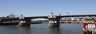
St. Johns is a neighborhood of Portland, Oregon, United States, located in North Portland on the tip of the peninsula formed by the confluence of the Willamette River and the Columbia River. The iconic St. Johns Bridge crosses the Willamette from the south, leading into downtown St. Johns. It was a separate, incorporated city from 1902 until 1915, when citizens of both St. Johns and Portland voted to approve its annexation to Portland, which took effect on July 8, 1915.

Waterways is a suburb in Melbourne, Victoria, Australia, 25 km (16 mi) south-east of Melbourne's Central Business District, located within the City of Kingston local government area. Waterways recorded a population of 2,422 at the 2021 census.
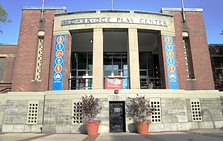
Highbridge Park is a public park on the western bank of the Harlem River in Washington Heights, Manhattan, New York City. It stretches between 155th Street and Dyckman Street in Upper Manhattan. The park is operated by the New York City Department of Parks and Recreation. The City maintains the southern half of the park, while the northern half is maintained by the non-profit New York Restoration Project. Prominent in the park are the Manhattan end of the High Bridge, the High Bridge Water Tower, and the Highbridge Play Center.

Gabriel Park is a 90.65-acre (366,800 m2) public park in Portland, Oregon, United States. It features a baseball field, softball field, soccer field, basketball courts, tennis courts, skatepark, volleyball courts, disabled access play area, disabled access restrooms, dog off-leash area, paved and unpaved paths, reservable picnic sites, and WiFi. The park is located between the Maplewood, Multnomah, and Hillsdale neighborhoods of Southwest Portland at 45th Avenue and Vermont Street.

The Burnside Skatepark is a DIY concrete skatepark located in Portland, Oregon, United States. Burnside was the first DIY skatepark project. It is located under the east end of the Burnside Bridge. The project was started without permission from the city of Portland before being accepted as a public skatepark. Its features include many hips, pools, pyramids, and vertical sections. The skatepark receives no funding from the city of Portland. The park is regarded as an on-going project that is funded by donations.

The Columbia Slough is a narrow waterway, about 19 miles (31 km) long, in the floodplain of the Columbia River in the U.S. state of Oregon. From its source in the Portland suburb of Fairview, the Columbia Slough meanders west through Gresham and Portland to the Willamette River, about 1 mile (1.6 km) from the Willamette's confluence with the Columbia. It is a remnant of the historic wetlands between the mouths of the Sandy River to the east and the Willamette River to the west. Levees surround much of the main slough as well as many side sloughs, detached sloughs, and nearby lakes. Drainage district employees control water flows with pumps and floodgates. Tidal fluctuations cause reverse flow on the lower slough.

Vancouver is a city on the north bank of the Columbia River in the U.S. state of Washington, located in Clark County. Founded in 1825 and incorporated in 1857, Vancouver had a population of 190,915 as of the 2020 census, making it the fourth-most populous city in Washington state. Vancouver is the seat of government of Clark County and forms part of the Portland-Vancouver metropolitan area, the 25th-largest metropolitan area in the United States. Originally established in 1825 around Fort Vancouver, a fur-trading outpost, the city is located on the Washington–Oregon border along the Columbia River, directly north of Portland.

Blue Lake Regional Park is a public park in Fairview, in the U.S. state of Oregon. The 101-acre (41 ha) park, near the south shore of the Columbia River in Multnomah County, includes many covered and uncovered picnic areas, playing fields for sports such as softball, a cross country course and infrastructure related to lake recreation including swimming, boating, and fishing. Encompassing wooded areas, three ponds, and a wetland in addition to the lake, the park is frequented by migrating birds and other wildlife. Paved paths run through the park, which is near the 40-Mile Loop hiking and biking trail. Park vegetation includes cottonwoods, willows, and other trees and shrubs as well as wetland plants such as cattails.
Reedville Creek Park is a municipal park in the Reedville neighborhood of Hillsboro, Oregon, United States. Opened in 2003, the 9.6-acre (39,000 m2) park is along Cornelius Pass Road at Francis Street in the southeast area of the city. The park includes basketball courts, children’s play equipment, a picnic shelter, tennis courts, and sports fields among other amenities. Reedville Creek was the first and is the only park in Hillsboro with a skatepark.
Wilsonville Memorial Park is a large municipal park in Wilsonville, Oregon, United States. Opened in 1969, the 126-acre (51 ha) park is the largest and oldest in the city. Located off Wilsonville Road east of Interstate 5, the park includes a plaza with water features, athletic fields and courts, trails, a skatepark, picnic areas, a dog park, and playground equipment. Part of the park fronts the Willamette River and includes a public boat dock.

Pioneer Courthouse Square, also known as Portland's living room, is a public space occupying a full 40,000-square-foot (3,700 m2) city block in the center of downtown Portland, Oregon, United States. Opened in 1984, the square is bounded by Southwest Morrison Street on the north, Southwest 6th Avenue on the east, Southwest Yamhill Street on the south, and Southwest Broadway on the west.

Director Park is a city park in Portland in the U.S. state of Oregon. Opened in 2009 at a cost of $9.5 million, it covers a 700-space underground parking garage, which connects underground to the Fox Tower and the Park Avenue West Tower. Located in downtown on Southwest Park Avenue, the nearly half-acre urban park lacks any natural areas and contains little vegetation.

Graham Oaks Nature Park is a 250 acres (100 ha) nature park in Wilsonville in the U.S. state of Oregon. Opened in 2010, the park is owned and operated by Metro, the regional government in the Oregon portion of the Portland metropolitan area.

Barretto Point Park is a waterfront public park on the East River located in the Hunts Point neighborhood of the Bronx. New York City. Its namesake is Francis J. Barretto, a 19th-century merchant and State Assemblyman who lived in the area.


