
The Willamette River is a major tributary of the Columbia River, accounting for 12 to 15 percent of the Columbia's flow. The Willamette's main stem is 187 miles (301 km) long, lying entirely in northwestern Oregon in the United States. Flowing northward between the Oregon Coast Range and the Cascade Range, the river and its tributaries form the Willamette Valley, a basin that contains two-thirds of Oregon's population, including the state capital, Salem, and the state's largest city, Portland, which surrounds the Willamette's mouth at the Columbia.

The East Coast Greenway is a 3,000-mile (4,800 km) pedestrian and bicycle route between Maine and Florida along the East Coast of the United States. The nonprofit East Coast Greenway Alliance was created in 1991 with the goal to use the entire route with off-road, shared-use paths; as of 2021, over 1,000 mi (1,600 km) of the route (35%) meets these criteria. In 2020, the Greenway received over 50 million visits.

The Portland Aerial Tram or OHSU Tram is an aerial tramway in Portland, Oregon, that connects the city's South Waterfront district and the main Oregon Health & Science University (OHSU) campus, located in the Marquam Hill neighborhood. It is one of only two commuter aerial tramways in the United States, the other being New York City's Roosevelt Island Tramway. The tram travels a horizontal distance of 3,300 feet (1,000 m) and a vertical distance of 500 feet (152 m) in a ride that lasts three minutes.

The Rose Fitzgerald Kennedy Greenway is a linear park located in several Downtown Boston neighborhoods. It consists of landscaped gardens, promenades, plazas, fountains, art, and specialty lighting systems that stretch over one mile through Chinatown, the Financial District, the Waterfront, and North End neighborhoods. Officially opened in October 2008, the 17-acre Greenway sits on land created from demolition of the John F. Fitzgerald Expressway as part of the Big Dig project.

Governor Tom McCall Waterfront Park is a 36.59-acre (148,100 m2) park located in downtown Portland, Oregon, along the Willamette River. After the 1974 removal of Harbor Drive, a major milestone in the freeway removal movement, the park was opened to the public in 1978. The park covers 13 tax lots and is owned by the City of Portland. The park was renamed in 1984 to honor Tom McCall, the Oregon governor who pledged his support for the beautification of the west bank of the Willamette River—harkening back to the City Beautiful plans at the turn of the century which envisioned parks and greenways along the river. The park is bordered by RiverPlace to the south, the Steel Bridge to the north, Naito Parkway to the west, and Willamette River to the east. In October 2012, Waterfront Park was voted one of America's ten greatest public spaces by the American Planning Association.

Downtown Portland is the central business district of Portland, Oregon, United States. It is on the west bank of the Willamette River in the northeastern corner of the southwest section of the city and where most of the city's high-rise buildings are found.

The South Waterfront is a high-rise district under construction on former brownfield industrial land in the South Portland neighborhood south of downtown Portland, Oregon, U.S. It is one of the largest urban redevelopment projects in the United States. It is connected to downtown Portland by the Portland Streetcar and MAX Orange Line, and to the Oregon Health & Science University (OHSU) main campus atop Marquam Hill by the Portland Aerial Tram, as well as roads to Interstate 5 and Oregon Route 43.

Air Line State Park Trail is a rail trail and linear state park located in Connecticut. The trail is divided into sections designated South, North a piece of the East Coast Greenway, and the Thompson addition. An additional 3.6-mile spur to Colchester is sometimes designated as part of the Air Line trail. At the Massachusetts state line, the trail connects to the Southern New England Trunkline Trail, a 22-mile-long trail to Franklin, MA built on the same right-of-way. Since 2018, the town of Portland, Connecticut has also maintained a 2.3-mile portion of the Air Line trail, connecting to the southern end of the state park at the town line with East Hampton.

Brooklyn Bridge Park is an 85-acre (34 ha) park on the Brooklyn side of the East River in New York City. Designed by landscape architecture firm Michael Van Valkenburgh Associates, the park is located on a 1.3-mile (2.1 km) plot of land from Atlantic Avenue in the south, under the Brooklyn Heights Promenade and past the Brooklyn Bridge, to Jay Street north of the Manhattan Bridge. From north to south, the park includes the preexisting Empire–Fulton Ferry and Main Street Parks; the historic Fulton Ferry Landing; and Piers 1–6, which contain various playgrounds and residential developments. The park also includes Empire Stores and the Tobacco Warehouse, two 19th-century structures, and is a part of the Brooklyn Waterfront Greenway, a series of parks and bike paths around Brooklyn.

The Manhattan Waterfront Greenway is a waterfront greenway for walking or cycling, 32 miles (51 km) long, around the island of Manhattan, in New York City. The largest portions are operated by the New York City Department of Parks and Recreation. It is separated from motor traffic, and many sections also separate pedestrians from cyclists. There are three principal parts — the East, Harlem and Hudson River Greenways.

The Hudson River Waterfront Walkway, also known as the Hudson River Walkway, is a promenade along the Hudson Waterfront in New Jersey. The ongoing and incomplete project located on Kill van Kull and the western shore of Upper New York Bay and the Hudson River was implemented as part of a New Jersey state-mandated master plan to connect the municipalities from the Bayonne Bridge to the George Washington Bridge with an urban linear park and provide contiguous unhindered access to the water's edge.

Hackensack River Greenway, once known as the Hackensack RiverWalk, a is partially constructed greenway along the Newark Bay and Hackensack River in Hudson County, New Jersey, United States.
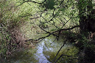
Fanno Creek is a 15-mile (24 km) tributary of the Tualatin River in the U.S. state of Oregon. Part of the drainage basin of the Columbia River, its watershed covers about 32 square miles (83 km2) in Multnomah, Washington, and Clackamas counties, including about 7 square miles (18 km2) within the Portland city limits.

Tilikum Crossing, Bridge of the People is a cable-stayed bridge across the Willamette River in Portland, Oregon, United States. It was designed by TriMet, the Portland metropolitan area's regional transit authority, for its MAX Orange Line light rail passenger trains. The bridge also serves city buses and the Portland Streetcar, as well as bicycles, pedestrians, and emergency vehicles. Private cars and trucks are not permitted on the bridge. It is the first major bridge in the U.S. that was designed to allow access to transit vehicles, cyclists and pedestrians but not cars.

The East River Greenway is an approximately 9.44-mile-long (15.19 km) foreshoreway for walking or cycling on the east side of the island of Manhattan on the East River. It is part of the Manhattan Waterfront Greenway. The largest portions are operated by the New York City Department of Parks and Recreation. It is separated from motor traffic, and many sections also separate pedestrians from cyclists. The greenway is parallel to the Franklin D. Roosevelt East River Drive for a majority of its length.
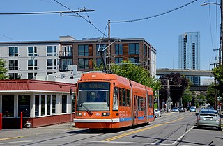
The North South Line is a streetcar service of the Portland Streetcar system in Portland, Oregon, United States. Operated by Portland Streetcar, Inc. and TriMet, it travels approximately 4.1 miles (6.6 km) per direction from Northwest 23rd & Marshall to Southwest Lowell & Bond and serves 39 stations. The line connects Portland's Northwest District, Pearl District, downtown, Portland State University (PSU), and South Waterfront. It runs every day of the week between 15 and 18 hours per day and operates on headways of 15 to 20 minutes.
The James Beard Public Market is a proposed public market in Portland, Oregon. It is named after James Beard, a Portland-born chef and cookbook writer. The market was planned to be located at the west end of the Morrison Bridge in downtown Portland, in what are currently parking lots, but this site was dropped in November 2016 after concerns over pedestrian accessibility due to the bridgehead ramps. The developer, Melvin Mark Development, still plans to build a 17-story building at the same site. Original designs for the market called for it to have two halls, totaling 80,000 square feet (7,400 m2), along with 60 permanent and 30 to 40 temporary stalls for food vendors. Design for the market is being led by the Norwegian architectural firm Snøhetta.

The A and B Loop is a streetcar circle route of the Portland Streetcar system in Portland, Oregon, United States. Operated by Portland Streetcar, Inc. and TriMet, it is made up of two separate services: the 6.1-mile (9.8 km) A Loop, which runs clockwise, and the 6.6-mile (10.6 km) B Loop, which runs counterclockwise. The route travels a loop between the east and west sides of the Willamette River by crossing the Broadway Bridge in the north and Tilikum Crossing in the south.

Vancouver Waterfront Park is a 7.3-acre (3.0 ha) waterfront park in Vancouver, Washington, in the United States.

The South Bronx Greenway is a project to improve waterfront access, recreational facilities, and transportation systems, including pedestrian and bicycle paths, in the South Bronx in New York City.
