Brooklyn is a mostly residential neighborhood in southeast Portland, Oregon. It sits along the east side of the Willamette River in the vicinity of Reed College. Founded as a neighborhood in the late 1860s, the neighborhood today is a middle-class area comprising mainly single family homes, interspersed with remaining industrial sites along the river and a large railyard. This railyard was home to Southern Pacific 4449 as well as several other large antique steam and diesel-electric locomotives.

The Hawthorne District in Portland, Oregon, is an area of Southeast Portland on SE Hawthorne Blvd. that runs from 12th to 60th Avenues, with the primary core of businesses between 30th and 50th Avenues. The area has numerous retail stores, including clothing shops, restaurants, bars, brewpubs, and microbreweries.
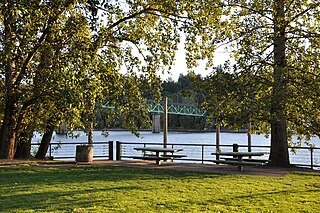
Sellwood-Moreland is a neighborhood on a bluff overlooking the Willamette River in Southeast Portland, Oregon, bordering Brooklyn to the north, Eastmoreland to the east, and the city of Milwaukie to the south. The neighborhood is linked to Southwest Portland across the Willamette River by the Sellwood Bridge, the southernmost of Portland's bridges.
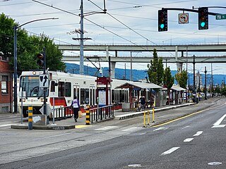
Albina/Mississippi station is a light rail station on the MAX Yellow Line in Portland, Oregon, United States. It is the second stop northbound on the Interstate MAX extension. The station is located in the median of Interstate Avenue near the intersection of N Albina Street. The station serves the Lower Albina Industrial District, Emanuel Hospital, and an emerging and redeveloping commercial district. The station is a center platform, with its main artistic theme drawing upon the lively jazz scene that thrived in Albina in the post-World War II era. During planning for Interstate MAX, this station was located at the intersection of Interstate Avenue and Russell Street. The Union Pacific Railroad raised concerns on conflicts between pedestrian and truck traffic at the Russell Street intermodal entrance to Albina Yard, which led designers to shift the station two blocks south.

St. Johns is a neighborhood of Portland, Oregon, United States, located in North Portland on the tip of the peninsula formed by the confluence of the Willamette River and the Columbia River. It was a separate, incorporated city from 1902 until 1915, when citizens of both St. Johns and Portland voted to approve its annexation to Portland, which took effect on July 8, 1915.
Kenton is a neighborhood in the north section of Portland, Oregon, United States. The neighborhood was originally a company town founded in 1911 for the Swift Meat Packing Company.
Highland Park was a city near and eventually neighborhood in Louisville, Kentucky, United States, that was razed as a part of the expansion of Louisville International Airport. Its boundaries were roughly the CSX railroad tracks to the west, and what would become the Kentucky State Fair & Exposition Center and the airport on all other sides.

East Portland was a city in the U.S. state of Oregon that was consolidated into Portland in 1891. In modern usage, the term generally refers to the portion of present-day Portland that lies east of 82nd Avenue, most of which the City of Portland annexed in the 1980s and 1990s.
University Park is a neighborhood in the north section of Portland, Oregon on the east shore of the Willamette River. University Park is bounded by North Lombard Street and the Portsmouth neighborhood to the north, North Chautauqua Boulevard and the Arbor Lodge neighborhood to the east, The Willamette River and Mock's Bottom industrial area to the south, and the North Portland railroad cut with Cathedral Park and St. Johns neighborhoods to the west.
Eliot is a neighborhood in the North and Northeast sections of Portland, Oregon. It is approximately bounded by the Willamette River on the west, NE Fremont Street on the north, NE 7th Avenue on the east, and NE/N Broadway on the south.
Parkrose is a neighborhood in the Northeast section of Portland, Oregon, and is considered part of East Portland. It is bordered by Sumner to the west, the Columbia River to the north, Argay to the east, and Parkrose Heights and the city of Maywood Park to the south. Sandy Boulevard crosses the neighborhood, with a primarily industrial area prevailing to the north and primarily residential area to the south.

The Albina Yard is a 200-acre (81 ha) rail yard located in the Albina District of Portland, Oregon, currently operated by the Union Pacific Railroad. One of several yards operated by the Union Pacific Railroad in Portland, as of year 2000 the Albina yard processes an average of 1,200 rail cars a day.

The Patton Home is a historic building and low-income housing facility in Portland, Oregon, United States. It was once known as the Patton Home for the Friendless. It was listed on the National Register of Historic Places in 2021.
The East Portland Grand Avenue Historic District, located in southeast Portland, Oregon, is listed on the National Register of Historic Places. The district includes approximately 20 city blocks on or near Southeast Grand Avenue on the east side of the Willamette River, roughly bounded on the south by SE Main Street, north by SE Ankeny Street, west by SE Martin Luther King Jr. Boulevard, and east by SE Seventh Avenue. Most structures in the district are commercial buildings rising two to three stories. Immediately to the west of the historic district is Portland's east side industrial area, and to the east are industrial and residential areas.

North Williams Avenue is a north-south street located in Portland, Oregon, United States, and it defines the eastern boundary of North Portland. North Williams Avenue stretches from its southern terminus at Northeast Winning Way, near the Moda Center, to its northern terminus at North Winchell Street, a distance of 3.3 miles (5.3 km). It is a street common to the Portland neighborhoods Eliot, Boise, Humboldt, and Piedmont.
The Mayo House is a historical house built by Martin Nicholas Mayo in the 1890s. It was built in Portland, Oregon's Eliot neighborhood. It is notable for being relocated in 1912, 1930, and 2019 to avoid demolition in order to make room for new construction projects. The house utilizes the Queen Anne architecture style. The relocation of the house in 2019 will see the house repurposed by local artist Cleo Davis as a site for local art and history to be archived and made available for the public. This new archive will be used to show the history of African-Americans in the local area of Portland. In order to reduce the cost of the relocation, the Portland City Council waived $40,000 in fees. The house was relocated in late January 2019.

Albina is a collection of neighborhoods located in the North and Northeast sections of Portland, Oregon, United States. For most of the 20th century it was home to the majority of the city’s African American population. The area derives its name from Albina, Oregon, a historical American city that was consolidated into Portland in 1891. Albina includes the modern Portland neighborhoods of Eliot, Boise, Humboldt, Overlook, and Piedmont.

Lombard Street is a main thoroughfare in Portland, Oregon, United States. It serves as a boundary and main commercial street for several north Portland neighborhoods.
Hawthorne Boulevard is an east–west street in Portland, Oregon, and the dividing line between multiple neighborhoods, although "Hawthorne" is often itself considered its own neighborhood. The street stretches from the Willamette River on the west,, and 92nd Avenue on the east. Mount Tabor blocks the street between 60th Street and 72nd Avenue. Hawthorne Boulevard is a principal street west of 50th Avenue and a residential street to the east. The most famous portion of Hawthorne Boulevard is between 29th Avenue and Cesar Chavez Boulevard serving as a cultural hot spot for Portland's hippie movement. This section of the street is filled with local businesses, boutiques, restaurants, and gift stores, as well as the first Fred Meyer grocery at 36th and Hawthorne, and a bakery at 12th and Hawthorne. It the grocery closed in the 1930s. Hawthorne Boulevard is often compared to Haight Street in San Francisco due to the similar culture of both streets. The street is named for Doctor James C. Hawthorne, a politician and physician. Dr. Hawthorne donated land for the Oregon Hospital for the Insane near the modern day Colonel Summers Park in 1862. The Hospital for the Insane is often called the Hawthorne Asylum, and the street, originally named U Street, took on the moniker Asylum Avenue. The Asylum closed in 1883, and an ordinance was passed to rename the street to Hawthorne Avenue in 1888.

Louisa Flowers (1849–1928) was a civic leader and property owner in Portland, Oregon where she was a resident for 45 years.
