Related Research Articles

The Oregon Trail was a 2,170-mile (3,490 km) east–west, large-wheeled wagon route and emigrant trail in the United States that connected the Missouri River to valleys in Oregon Territory. The eastern part of the Oregon Trail spanned part of what is now the state of Kansas and nearly all of what are now the states of Nebraska and Wyoming. The western half of the trail spanned most of the current states of Idaho and Oregon.

Elgin is a city in Union County, Oregon, United States. The population was 1,711 at the 2010 census. The community is named after the Lady Elgin, a ship lost on Lake Michigan.

Summerville is a city in Union County, Oregon, United States. The population was 135 at the 2010 census.

The Grande Ronde River is a 210-mile (340 km) long tributary of the Snake River, flowing through northeast Oregon and southeast Washington in the United States. Its watershed is situated in the eastern Columbia Plateau, bounded by the Blue Mountains and Wallowa Mountains to the west of Hells Canyon. The river flows generally northeast from its forested headwaters west of La Grande, Oregon, through the agricultural Grande Ronde Valley in its middle course, and through rugged canyons cut from ancient basalt lava flows in its lower course. While it joins the Snake River upstream of Asotin, Washington, more than 90 percent of the river's watershed is in Oregon.

The Oregon Railroad and Navigation Company (OR&N) was a rail and steamboat transport company that operated a rail network of 1,143 miles (1,839 km) running east from Portland, Oregon, United States, to northeastern Oregon, northeastern Washington, and northern Idaho. It operated from 1896 as a consolidation of several smaller railroads.

The Oregon Steam Navigation Company (O.S.N.) was an American company incorporated in 1860 in Washington with partners J. S. Ruckle, Henry Olmstead, and J. O. Van Bergen. It was incorporated in Washington because of a lack of corporate laws in Oregon, though it paid Oregon taxes.
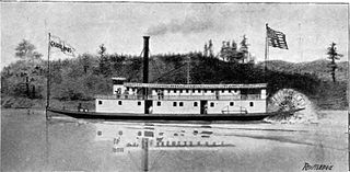
The Colonel Wright was the first steamboat to operate on the Columbia River above The Dalles in the parts of the Oregon Country that later became the U.S. states of Oregon, Washington and Idaho. She was the first steamboat to run on the Snake River. She was named after Colonel George Wright, an army commander in the Indian Wars in the Oregon Country in the 1850s. She was generally called the Wright during her operating career.

The Belle of Oregon City, generally referred to as Belle, was built in 1853, and was the first iron steamboat built on the west coast of North America.

The Shoshone was the first steamboat built on the Snake River, Idaho, above Hells Canyon and the first of only two steamboats to be brought down through Hells Canyon to the lower Snake River. This was considered one of the most astounding feats of steamboat navigation ever accomplished.

Onward was an early steamboat on the Willamette River built at Canemah, Oregon in 1858. This vessel should not be confused other steamboats named Onward, including in particular the Onward of 1867, a similar but somewhat smaller vessel built at Tualatin Landing, which operated on the Tualatin River under Capt. Joseph Kellogg.

James D. Miller (1830-1914) was a steamboat captain in the Pacific Northwest from 1851 to 1903. He became well known for his long length of service, the large number of vessels he commanded, and the many different geographical areas in which he served.
The Grande Ronde Valley is a valley in Union County in northeastern Oregon, United States. It is surrounded by the Blue Mountains and Wallowa Mountains, and is drained by the Grande Ronde River. La Grande is its largest community. The valley is 35 miles (56 km) long, north to south, from Pumpkin Ridge to Pyles Canyon, and 15 miles (24 km) wide, east to west, from Cove to the Grande Ronde River's canyon. Its name, fittingly, means, "great circle."

The Tenino was the second steamboat to run on the Columbia River above Celilo Falls and on the Snake River. Following a reconstruction or major salvage in 1876 this vessel was named the New Tenino.
The Carrie Ladd was an important early steamboat on the lower Columbia and lower Willamette rivers. The vessel established the basic design of the Columbia River steamboat, which was later used throughout the Pacific Northwest, British Columbia, Alaska, and the Yukon.
The history of rail in Oregon predates the transcontinental railroad in 1869.
Colonel Joseph S. Ruckle was a businessman who moved to Oregon in 1855.

The Oregon Portage Railroad was the first railroad in the U.S. state of Oregon. It was located on the south bank of the Cascades canal of the Columbia River.

Emma Hayward commonly called the Hayward, was a steamboat that served in the Pacific Northwest. This vessel was once one of the finest and fastest steamboats on the Columbia River and Puget Sound. As newer vessels came into service, Emma Hayward was relegated to secondary roles, and, by 1891, was converted into a Columbia river tow boat.

The People's Transportation Company operated steamboats on the Willamette River and its tributaries, the Yamhill and Tualatin rivers, in the State of Oregon from 1862 to 1871. For a brief time this company operated steamers on the Columbia River, and for about two months in 1864, the company operated a small steamer on the Clackamas River.

Orient was a light-draft sternwheel-driven steamboat built in 1875 for the Willamette River Transportation Company, a concern owned by pioneer businessman Ben Holladay. Shortly after its completion, it was acquired by the Oregon Steam Navigation Company. Orient was a near-twin vessel of a steamer built at the same time, the Occident.
References
- 1 2 3 4 5 6 7 Deumling, Dietrich (May 1972). The roles of the railroad in the development of the Grande Ronde Valley (masters thesis). Flagstaff, Arizona: Northern Arizona University. pp. 13–15, 27–28. OCLC 4383986.
- ↑ Bancroft, Hubert Howe (1888). History of Oregon. Vol. II. p. 481.
- 1 2 Bailey, Barbara Ruth (1982). Main Street: Northeastern Oregon. Oregon Historical Society. p. 106. ISBN 0-87595-073-6.