
Oregon Route 10 is an Oregon state highway which serves Portland and some of its western suburbs.
Multnomah is a neighborhood in the southwest section of Portland, Oregon, centered on the Multnomah Village business district. The community developed in the 1910s around a depot of the Oregon Electric Railway of the same name. It was annexed by the city of Portland on November 7, 1950.

Kings Hill/Southwest Salmon Street is a closed light rail station in Portland, Oregon, United States, which prior to closure had been served by the Blue and Red lines of TriMet's MAX Light Rail. The station is situated within the Goose Hollow neighborhood. Its incorrectly punctuated name refers to the hillside to the west of the station, which has historically been referred to as King's Hill. A section of King's Hill, which contains many historic buildings, qualified for inclusion within the King's Hill Historic District, the easternmost boundary of which is at SW 21st Avenue.
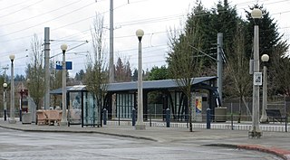
Willow Creek/Southwest 185th Avenue Transit Center is a transport hub in Hillsboro, Oregon, United States. Owned and operated by TriMet, it is a light rail and bus station. The transit center is the ninth station eastbound on the Blue Line and a hub for bus routes mostly serving Washington County in the Portland metropolitan area. It is located by the intersection of Southwest Baseline Road and 185th Avenue near the city's boundary with Beaverton. Opened in 1998, the station was originally conceived as the western terminus of the Westside MAX, but the line was extended further west into Hillsboro, due to population growth occurring at the time the line was being planned. Artwork at the stop represents a reading motif, as a library was planned for the station, but never built. Willow Creek is near the Oregon National Primate Research Center and the rest of the Oregon Health & Science University's West Campus in the Tanasbourne neighborhood.

Oregon Route 210 is a state highway which runs between the community of Scholls, Oregon and the Raleigh Hills neighborhood west of Portland, terminating at the Sylvan overpass on Highway 26. It has become an important route for both commuters and agriculture through Washington County. Oregon Route 210 is signed from east-to-west; though in actuality it runs in a northeast-to-southwest direction.

Downtown Portland is the central business district of Portland, Oregon, United States. It is on the west bank of the Willamette River in the northeastern corner of the southwest section of the city and where most of the city's high-rise buildings are found.

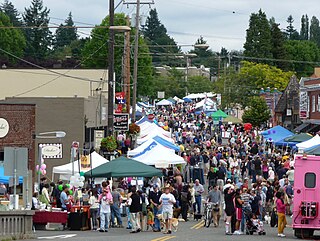
The Hillsdale district is a neighborhood in the southwest section of Portland, Oregon, United States. It is centered on the Hillsdale retail and business area, a series of strip malls on SW Capitol Highway between SW Sunset Boulevard and SW Bertha Boulevard. It is home to the Hillsdale Farmer's Market, which takes place on Sundays during the summer and every other Sunday during the winter. Hillsdale is also home to Oregon's first brewpub, with the opening of McMenamins Hillsdale Brewery in 1985.
Maplewood is a suburban neighborhood in Southwest Portland, Oregon, United States.
South Portland is a long, narrow neighborhood just south of Downtown Portland, Oregon, hemmed in between the Willamette River and the West Hills. It stretches from I-405 and the Marquam Bridge on the north, to SW Canby St. and the Sellwood Bridge in the south. The Willamette forms the eastern boundary, and SW Barbur Blvd. most of the western boundary. In addition to Downtown to the north, other bordering neighborhoods are Southwest Hills, Homestead, Hillsdale, and South Burlingame to the west, and Hosford-Abernethy, Brooklyn, and Sellwood-Moreland across the river on the east.
Hayhurst is a neighborhood in the southwest section of Portland, Oregon, on the border with Washington County. It borders Raleigh Hills and Beaverton, and the Portland neighborhoods of Bridlemile, Hillsdale, and Maplewood and Multnomah.
Southwest Hills is a neighborhood in the West Hills in the southwest section of Portland, Oregon, United States. The northeastern part of the neighborhood, above Goose Hollow and Downtown Portland, is known as Portland Heights. Much of the western portion of the neighborhood lies outside the Portland city limits, in unincorporated Multnomah County.
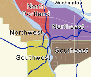
Portland, Oregon is divided into six sections: North Portland, Northeast Portland, Northwest Portland, South Portland, Southeast Portland, and Southwest Portland. There are 95 officially recognized neighborhoods, each of which is represented by a volunteer-based neighborhood association. No neighborhood associations overlap the Willamette River, but a few overlap the addressing sextants. For example, most addresses in the South Portland Neighborhood Association are South, but a portion of the neighborhood is west of SW View Point Terrace where addresses have a SW prefix. Similarly the Buckman Neighborhood Association spans both NE and SE Portland.
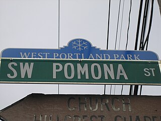
West Portland Park is a neighborhood in the Southwest section of Portland, Oregon. It lies between SW 53rd Ave. in the west and SW 35th Ave. in the east, and I-5 in the north and SW Stephenson St. in the south. South of SW Pomona St., the western border is SW 49th Ave. The neighborhood borders Crestwood and Far Southwest to the west, Multnomah to the north, Markham and Arnold Creek to the east, and the city of Lake Oswego to the south.
Markham is a neighborhood in the Southwest section of Portland, Oregon. Markham is bordered by Multnomah and South Burlingame on the north, Marshall Park on the east, Arnold Creek on the south, and West Portland Park on the west.

Canyon Road is a 6.5 mi (10.5 km) major road and partial state highway, which serves as a connector between Beaverton and Portland, Oregon, United States. It was the first major road constructed between the Tualatin Valley and Portland, and has contributed significantly to Portland becoming the area's major deep water port, and subsequent early growth of the city. The total modern length is 6.5 miles (10.5 km), and 2.7 miles (4.3 km) of the route is coterminous with U.S. Route 26. In addition, the segment of the road signed as Oregon Route 8 under the name Canyon Road spans for 3.8 miles (6.1 km). There is an additional, small portion of a driveway in the Oregon Zoo parking lot that is also named Canyon Road; this is a continuation of a local suburban street named Canyon Court.
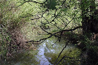
Fanno Creek is a 15-mile (24 km) tributary of the Tualatin River in the U.S. state of Oregon. Part of the drainage basin of the Columbia River, its watershed covers about 32 square miles (83 km2) in Multnomah, Washington, and Clackamas counties, including about 7 square miles (18 km2) within the Portland city limits.

Portland, Oregon contains six public school districts, many private schools, as well as public and private colleges and universities including Portland State University, the largest public university in Oregon.

Tualatin Valley Fire & Rescue (TVF&R) is a special-purpose government fire fighting and emergency services district in the Portland metropolitan area of Oregon. Established in 1989 with a merger between Washington County Fire District 1 and the Tualatin Rural Fire Protection District, it primarily provides fire and emergency medical services in eastern Washington County, but also provides services in neighboring Multnomah, Clackamas, and Yamhill counties. It serves unincorporated areas along with the cities of Beaverton, Tigard, Tualatin, West Linn, Wilsonville, and Sherwood, among others. With over 400 firefighters and 27 fire stations, the district is the second largest fire department in the state and has an annual budget of $197 million.

The Tualatin Hills Nature Park is a 222-acre nature park and wildlife preserve in Beaverton, Oregon, owned by the Tualatin Hills Park & Recreation District (THPRD). It is one of THPRD's two nature parks along with Cooper Mountain Nature Park. The park features 5 miles (8 km) of trails, of which 1.5 miles are paved and 3.5 miles unpaved. The park features a diverse environment including several types of both evergreen and deciduous trees as well as creeks, wetlands, ponds, and meadows. Located on 15655 S.W. Millikan Way, at the main entrance to the park, is the Tualatin Hills Nature Center, formerly called the Tualatin Hills Nature Park Interpretive Center. The name was changed in November 2014. Nature supervisor Kristin Atman said that "six words is really a mouthful" and the new name would be more consistent with THPRD's other facilities.

Southwest Portland is one of the sextants of Portland, Oregon.

