
The Hawthorne District in Portland, Oregon, is an area of Southeast Portland on SE Hawthorne Blvd. that runs from 12th to 60th Avenues, with the primary core of businesses between 30th and 50th Avenues. The area has numerous retail stores, including clothing shops, restaurants, bars, brewpubs, and microbreweries.

Mount Tabor is a neighborhood in Southeast Portland that takes its name from the volcanic cinder cone and city park on the volcano that it surrounds, in the U.S. state of Oregon. The name refers to Mount Tabor, Israel. It was named by Plympton Kelly, son of Oregon City pioneer resident Clinton Kelly.

Buckman is a neighborhood in the Southeast section of Portland, Oregon. The neighborhood is bounded by the Willamette River on the west, E Burnside St. on the north, SE 28th Ave. on the east, and SE Hawthorne Blvd. on the south.
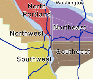
Portland, Oregon is divided into six sections: North Portland, Northeast Portland, Northwest Portland, South Portland, Southeast Portland, and Southwest Portland. There are 95 officially recognized neighborhoods, each of which is represented by a volunteer-based neighborhood association. No neighborhood associations overlap the Willamette River, but a few overlap the addressing sextants. For example, most addresses in the South Portland Neighborhood Association are South, but a portion of the neighborhood is west of SW View Point Terrace where addresses have a SW prefix. Similarly the Buckman Neighborhood Association spans both NE and SE Portland.
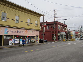
The Belmont Area is a retail and residential district running along SE Belmont St. in the inner Southeast section of Portland, Oregon in a parallel fashion to the Hawthorne District, 6 blocks to the south. From west to east the area extends 48 blocks, from SE 12th Ave. to SE 60th Ave., passing through the Buckman, Sunnyside, and Mount Tabor neighborhoods. The area is seven blocks wide, running from SE Belmont St. 4 blocks north to SE Stark St. and 3 blocks south to SE Salmon St. SE Belmont St. between SE 33rd Ave. and SE 35th Ave., in Sunnyside, is the heart of the district.

Foster-Powell is a neighborhood in the Southeast section of Portland, Oregon. The triangular neighborhood is bounded by three major transit arteries: Powell Boulevard to the north, Foster Road to the south, and 82nd Avenue to the east.
Montavilla is a neighborhood in the Northeast and Southeast sections of Portland, Oregon, United States, and contains an area east of Mount Tabor and west of Interstate 205, from the Banfield to SE Division. It is bordered by North Tabor, Mount Tabor, South Tabor, Madison South, Hazelwood, and Powellhurst-Gilbert.

The City Repair Project is a 501(c)(3) non-profit organization based in Portland, Oregon. Its focus is education and activism for community building. The organizational motto is "The City Repair Project is group of citizen activists creating public gathering places and helping others to creatively transform the places where they live."

Avalon Theatre, established as the Sunnyside Theatre in 1912, is the oldest operating movie theater in Portland, Oregon, and is believed to be the state's oldest theater and the first with more than one screen.
The F. M. Knight Building in southeast Portland in the U.S. state of Oregon is a two-story general commercial building listed on the National Register of Historic Places. Built in an Italianate style in about 1890, it was added to the register in 1989.

Portland Fire Station No. 7, located in southeast Portland in the U.S. state of Oregon, is a two-story structure listed on the National Register of Historic Places. Built in 1927, it was added to the register in 1989. It was the last of numerous Portland firehouses to be designed by fire chief and architect Lee Gray Holden, who died of a stroke while visiting the No. 7 firehouse in 1943. The building continued to be used by the city's Fire Department until the 1980s, when it was sold off and used as an automobile garage. It was acquired by a local developer in 2009, and was restored and remodeled for office and retail use.

The Belmont Library is a branch of the Multnomah County Library, located in Belmont, Portland, Oregon. The original library building opened in 1924 and was expanded in 1937 with the addition of a children's room. The brick building had small round windows and large oak tables. Renovations during 1999–2000 nearly doubled the library's capacity.

Clinton Street/Southeast 12th Avenue station is a MAX Orange Line station located at 1229 Southeast Gideon Street in Portland, Oregon's Hosford-Abernethy neighborhood, in the United States. The sculpture Intersection is installed at the station.

The Hawthorne Theatre, formerly known as the Sunnyside Masonic Lodge, is an historic building and music venue located at the intersection of Southeast Hawthorne Boulevard and Cesar Chavez Boulevard, in Portland, Oregon's Richmond neighborhood, in the United States. The building was completed in 1919, and formerly housed the restaurant Lucky Strike, as well as Conan's, a bar and music venue. It sold for approximately $2 million in 2005 and $3 million in 2013.

Southeast Portland is one of the sextants of Portland, Oregon.
Hawthorne Boulevard is an east–west street in Portland, Oregon, and the dividing line between multiple neighborhoods, although "Hawthorne" is often itself considered its own neighborhood. The street stretches from the Willamette River on the west,, and 92nd Avenue on the east. Mount Tabor blocks the street between 60th Street and 72nd Avenue. Hawthorne Boulevard is a principal street west of 50th Avenue and a residential street to the east. The most famous portion of Hawthorne Boulevard is between 29th Avenue and Cesar Chavez Boulevard serving as a cultural hot spot for Portland's hippie movement. This section of the street is filled with local businesses, boutiques, restaurants, and gift stores, as well as the first Fred Meyer grocery at 36th and Hawthorne, and a bakery at 12th and Hawthorne. It the grocery closed in the 1930s. Hawthorne Boulevard is often compared to Haight Street in San Francisco due to the similar culture of both streets. The street is named for Doctor James C. Hawthorne, a politician and physician. Dr. Hawthorne donated land for the Oregon Hospital for the Insane near the modern day Colonel Summers Park in 1862. The Hospital for the Insane is often called the Hawthorne Asylum, and the street, originally named U Street, took on the moniker Asylum Avenue. The Asylum closed in 1883, and an ordinance was passed to rename the street to Hawthorne Avenue in 1888.
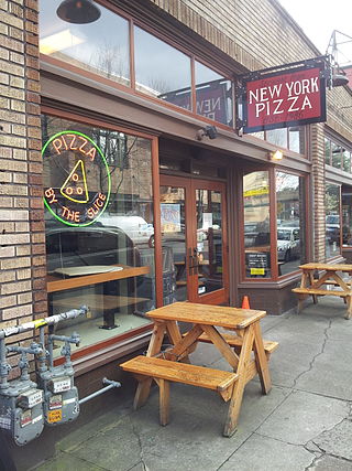
Straight from New York Pizza (SFNY) is a pizzeria based in the U.S. state of Oregon.

TarBoush Lebanese Bistro and Bar, or simply TarBoush, is a Lebanese restaurant in Portland, Oregon.
Tabor Bread is a bakery in Portland, Oregon's Sunnyside neighborhood, in the United States. Tissa Stein opened the bakery at the intersection of 50th and Hawthorne Boulevard in 2012. The business relocated to Belmont Street in 2022. Rebecca Tosdevin has owned the bakery since 2023, following Stein's retirement. The bakery has garnered a positive reception.

Belmont Station is a bar and bottle shop in Portland, Oregon. It operates at the intersection of Stark Street and 45th Avenue, in southeast Portland's Sunnyside neighborhood.


