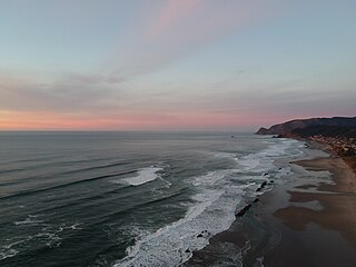
Lincoln City is a town in Lincoln County on the Oregon Coast of the United States, between Tillamook to the north and Newport to the south. It is named after the county, which was named in honor of former U.S. President Abraham Lincoln. The population was 9,815 at the 2020 Census.
Raleigh Hills is a census-designated place and neighborhood in Washington County, Oregon within the metropolitan area of Portland, Oregon, United States. It is located in the southwest hills in Washington County, with Beaverton to the west, West Slope to the north, and Progress and Garden Home to the south. As of the 2000 census, the census-designated place had a total population of 5,865.

Oregon Country was a large region of the Pacific Northwest of North America that was subject to a long dispute between the United Kingdom and the United States in the early 19th century. The boundaries of the area, which had been created by the Treaty of 1818 without recognizing indigenous claims to the area, consisted of the land north of 42° N latitude, south of 54°40′ N latitude, and west of the Rocky Mountains down to the Pacific Ocean and east to the Continental Divide. Article III of the 1818 treaty gave joint control to both nations for ten years, allowed land to be claimed, and guaranteed free navigation to all mercantile trade. However, both countries disputed the terms of the international treaty. Oregon Country was the American name, while the British used Columbia District for the region. Meanwhile, Indigenous nations had lived in the area since time immemorial, though with little legal recognition in the American and British legal systems. Evidence along the Salmon River shows people lived there at least 16,000 years ago and may have populated the continent after migrating along the Pacific Coast, then following up the Columbia River into the interior.
The Clatskanie River is a tributary of the Columbia River, approximately 25 miles (40 km) long, in northwestern Oregon in the United States. It drains a timber-producing area in the foothills of the Northern Oregon Coast Range north-northwest of Portland.
Mist is an unincorporated community in Columbia County, Oregon, United States. Formerly called Riverside, the place was renamed in 1888 for the atmospheric conditions of the Nehalem Valley. The first land claims in the area had been made circa 1870. The original Riverside post office was closed in 1975.
Orenco is a former company town in Washington County, Oregon, United States, located between Hillsboro and Aloha. The former community of Orenco now forms the Orenco neighborhood in Hillsboro, which is the site of the Orenco Station housing development.

Mount Tabor is a neighborhood in Southeast Portland that takes its name from the volcanic cinder cone and city park on the volcano that it surrounds, in the U.S. state of Oregon. The name refers to Mount Tabor, Israel. It was named by Plympton Kelly, son of Oregon City pioneer resident Clinton Kelly.

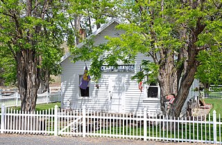
Westport is an unincorporated community and census-designated place on the Columbia River in Clatsop County, Oregon, United States. As of the 2010 census, it had a population of 321.

Knappa is an unincorporated community and census-designated place located on the south bank of the Columbia River in Clatsop County, Oregon, United States, approximately 12 miles (19 km) directly east of Astoria. Knappa faces the Columbia River, where several islands comprise the Lewis and Clark National Wildlife Refuge.

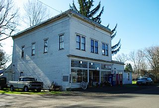
Brownsmead is an unincorporated community, on a distributary of the Columbia River called Saspal Slough, in Clatsop County, Oregon, United States. Previously known as Brody, it was named after W.G. Brown, a Portland engineer involved in land reclamation in the area. There was a post office in Brownsmead from 1919 to 1975, located in the Brownsmead General Store.
Sylvan-Highlands is a neighborhood of Portland, Oregon, United States located on the west side of the West Hills.
Centennial is a neighborhood on the eastern edge of the Southeast section of Portland, Oregon, on the border with Gresham. The neighborhood includes Lynchwood Park (1993) and Parklane Park (1993).

Sullivan's Gulch is a neighborhood in the Northeast section of Portland, Oregon. The name commemorates Timothy Sullivan, an early farmer in the area. Sullivan settled his donation land claim on January 27, 1851. He was born in Ireland in 1805, received citizenship in the United States in 1855, and most likely received title to the claim around 1863.

Bonneville is an unincorporated community in Multnomah County, Oregon, United States, on Interstate 84 and the Columbia River. Bonneville is best known as the site of Bonneville Dam. North Bonneville, Washington is across the river.

Dorena is an unincorporated community in Lane County, Oregon, United States. It is located southeast of Cottage Grove on the Row River, a tributary of the Coast Fork Willamette River.
Thurston is a neighborhood in the eastern part of Springfield, Oregon, United States on Oregon Route 126. Before being annexed by Springfield, it was formerly an unincorporated community with its own post office. The earliest land claims in the Thurston area by white settlers were in 1851. A small crossroads community, including a general store and a blacksmith shop, formed at the corner of Thurston Road and 66th Street. The settlement was named for pioneer George H. Thurston, son of Samuel Thurston. Thurston post office was established in 1877. The ZIP code for Thurston post office boxes is 97482. The ZIP code for delivered mail is 97478.
Woodson is an unincorporated community in Columbia County, Oregon, United States. It is located on U.S. Route 30 seven miles west of Clatskanie and three miles east of Westport, on Westport Slough, a tributary of the Columbia River. In December 2007, the debris overflow from the flooding of Eilersten Creek caused evacuations and mud cover on Woodson Road north of the highway.
Clarno is an unincorporated community in Wasco County, Oregon, United States. It is located along Oregon Route 218 near the John Day River.

Peoria is an unincorporated community and census-designated place (CDP) in Linn County, Oregon, United States. It is on the right bank of the Willamette River at river mile 141 between Eugene and Corvallis. Lacking stores and services, it is a cluster of houses plus a county park along Peoria Road, about 8 miles (13 km) south of Oregon Route 34 and 12 miles (19 km) north of Harrisburg. As of the 2010 census, the population was 94.
Tanner Creek is a small tributary of the Willamette River in Portland in the U.S. state of Oregon. Named after a tannery owned by one of the city's founders, it begins in what is now the Sylvan–Highlands neighborhood in the Tualatin Mountains west of downtown. In the 19th century the creek flowed on the surface, running northeast across the city, past what later became Providence Park and into a shallow lake and wetlands in what became the Pearl District, bordering the river.
