Portland is a port city in the Pacific Northwest and the most populous city in the U.S. state of Oregon. Situated in the northwestern area of the state at the confluence of the Willamette and Columbia rivers, Portland is the county seat of Multnomah County, the most populous county in Oregon. As of 2020, Portland had a population of 652,503, making it the 26th-most populated city in the United States, the sixth-most populous on the West Coast, and the second-most populous in the Pacific Northwest, after Seattle. Approximately 2.5 million people live in the Portland–Vancouver–Hillsboro, OR–WA metropolitan statistical area, making it the 25th most populous in the United States. About half of Oregon's population resides within the Portland metropolitan area.

Oregon City is the county seat of Clackamas County, Oregon, United States, located on the Willamette River near the southern limits of the Portland metropolitan area. As of the 2020 census, the city population was 37,572. Established in 1829 by the Hudson's Bay Company, in 1844 it became the first U.S. city west of the Rocky Mountains to be incorporated.

Interstate 5 (I-5) is the main north–south Interstate Highway on the West Coast of the United States, running largely parallel to the Pacific Coast of the contiguous U.S. from Mexico to Canada. It travels through the states of California, Oregon, and Washington, serving several large cities on the West Coast, including San Diego, Los Angeles, Sacramento, Portland, and Seattle. It is the only continuous Interstate highway to touch both the Mexican and Canadian borders. Upon crossing the Mexican border at its southern terminus, I-5 continues to Tijuana, Baja California, as Mexican Federal Highway 1 (Fed. 1). Upon crossing the Canadian border at its northern terminus, it continues to Vancouver as British Columbia Highway 99 (BC 99).

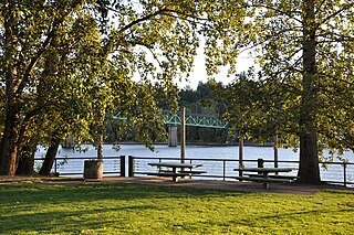
The Willamette River is a major tributary of the Columbia River, accounting for 12 to 15 percent of the Columbia's flow. The Willamette's main stem is 187 miles (301 km) long, lying entirely in northwestern Oregon in the United States. Flowing northward between the Oregon Coast Range and the Cascade Range, the river and its tributaries form the Willamette Valley, a basin that contains two-thirds of Oregon's population, including the state capital, Salem, and the state's largest city, Portland, which surrounds the Willamette's mouth at the Columbia.

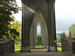
The St. Johns Bridge is a steel suspension bridge that spans the Willamette River in Portland, Oregon, United States, between the Cathedral Park neighborhood in North Portland and the Linnton and Northwest Industrial neighborhoods in Northwest Portland. It carries the U.S. Route 30 Bypass. It is the only suspension bridge in the Willamette Valley and one of three public highway suspension bridges in Oregon.

The Tualatin River is a tributary of the Willamette River in Oregon in the United States. The river is about 83 miles (134 km) long, and it drains a fertile farming region called the Tualatin Valley southwest and west of Portland at the northwest corner of the Willamette Valley. There are approximately 500,000 people residing on 15 percent of the land in the river's watershed.
Sellwood-Moreland is a neighborhood on a bluff overlooking the Willamette River in Southeast Portland, Oregon, bordering Brooklyn to the north, Eastmoreland to the east, and the city of Milwaukie to the south. The neighborhood is linked to Southwest Portland across the Willamette River by the Sellwood Bridge, the southernmost of Portland's bridges.

Downtown Portland is the central business district of Portland, Oregon, United States. It is on the west bank of the Willamette River in the northeastern corner of the southwest section of the city and where most of the city's high-rise buildings are found.

Oregon Route 43 is an Oregon state highway that runs between the cities of Oregon City and Portland, mostly along the western flank of the Willamette River. While it is technically known by the Oregon Department of Transportation as the Oswego Highway No. 3, on maps it is referred to by its route number or by the various street names it has been given.

St. Johns is a neighborhood of Portland, Oregon, United States, located in North Portland on the tip of the peninsula formed by the confluence of the Willamette River and the Columbia River. It was a separate, incorporated city from 1902 until 1915, when citizens of both St. Johns and Portland voted to approve its annexation to Portland, which took effect on July 8, 1915.
The Northwest District is a densely populated retail and residential neighborhood in the northwest section of Portland, Oregon, United States. Craftsman-style and Old Portland-style houses are packed tightly together with old apartment buildings and new condominiums, within walking distance of restaurants, bars, and shops. The Portland Streetcar's first line terminates there, connecting the district to the Pearl District, Downtown Portland and points south to the South Waterfront, and several TriMet bus lines also serve the district.
South Portland is a long, narrow neighborhood just south of Downtown Portland, Oregon, hemmed in between the Willamette River and the West Hills. It stretches from I-405 and the Marquam Bridge on the north, to SW Canby St. and the Sellwood Bridge in the south. The Willamette forms the eastern boundary, and SW Barbur Blvd. most of the western boundary. In addition to Downtown to the north, other bordering neighborhoods are Southwest Hills, Homestead, Hillsdale, and South Burlingame to the west, and Hosford-Abernethy, Brooklyn, and Sellwood-Moreland across the river on the east.
Linnton is a Portland, Oregon neighborhood located between Forest Park and the Willamette River along U.S. Route 30, close to the agricultural community of Sauvie Island. It borders the neighborhoods of Northwest Industrial on the south, St. Johns and Cathedral Park via the St. Johns Bridge across the Willamette on the east, and Forest Park on the west. The neighborhood extends north somewhat beyond Portland city limits into unincorporated Multnomah County, ending at the Sauvie Island Bridge.

Northwest Industrial Area is an almost entirely industrial neighborhood in the Northwest section of Portland. According to the Portland Bureau of Planning, it "is one of the few remaining large urban industrial districts in the United States" and "one of the premier heavy industrial districts in the Pacific Northwest". It borders the neighborhoods of Linnton on the north, Forest Park on the west, the Northwest District on the south, and Cathedral Park, University Park, and Overlook across the Willamette River on the east.

Buckman is a neighborhood in the Southeast section of Portland, Oregon. The neighborhood is bounded by the Willamette River on the west, E Burnside St. on the north, SE 28th Ave. on the east, and SE Hawthorne Blvd. on the south.
University Park is a neighborhood in the north section of Portland, Oregon on the east shore of the Willamette River. University Park is bounded by North Lombard Street and the Portsmouth neighborhood to the north, North Chautauqua Boulevard and the Arbor Lodge neighborhood to the east, The Willamette River and Mock's Bottom industrial area to the south, and the North Portland railroad cut with Cathedral Park and St. Johns neighborhoods to the west.
Interstate 5 (I-5) in the U.S. state of Oregon is a major Interstate Highway that traverses the state from north to south. It travels to the west of the Cascade Mountains, connecting Portland to Salem, Eugene, Medford, and other major cities in the Willamette Valley and across the northern Siskiyou Mountains. The highway runs 308 miles (496 km) from the California state line near Ashland to the Washington state line in northern Portland, forming the central part of Interstate 5's route between Mexico and Canada.

The Willamette River is a 187-mile (301 km) tributary of the Columbia River in the U.S. state of Oregon. The upper tributaries of the Willamette originate in mountains south and southeast of the twin cities of Eugene and Springfield. Formed by the confluence of the Middle Fork Willamette River and Coast Fork Willamette River near Springfield, the main stem meanders generally north from source to mouth. The river's two most significant course deviations occur at Newberg, where the stream turns sharply east, and about 18 miles (29 km) downriver from Newberg, where it turns north again. Near its mouth, the river splits into two channels that flow around Sauvie Island. The main channel enters the Columbia about 101 miles (163 km) from the larger stream's mouth on the Pacific Ocean, and the smaller Multnomah Channel enters the Columbia about 14.5 miles (23.3 km) further downstream near St. Helens in Columbia County.
Tanner Creek is a small tributary of the Willamette River in Portland in the U.S. state of Oregon. Named after a tannery owned by one of the city's founders, it begins in what is now the Sylvan–Highlands neighborhood in the Tualatin Mountains west of downtown. In the 19th century the creek flowed on the surface, running northeast across the city, past what later became Providence Park and into a shallow lake and wetlands in what became the Pearl District, bordering the river.

Cathedral Park is a park and the name for the eponymous neighborhood in the northernmost section of Portland, Oregon on the east shore of the Willamette River. The park is situated under the St. Johns Bridge, and was given its name due to the Gothic arches that support the bridge, which resemble a cathedral arch.