Mount Tabor is a neighborhood in Southeast Portland that takes its name from the volcanic cinder cone and city park on the volcano that it surrounds, in the U.S. state of Oregon. The name refers to Mount Tabor, Israel. It was named by Plympton Kelly, son of Oregon City pioneer resident Clinton Kelly.

Harbor Drive is a short roadway in Portland, Oregon, spanning a total length of 0.7 miles (1.1 km), which primarily functions as a ramp to and from Interstate 5. It was once much longer, running along the western edge of the Willamette River in the downtown area. Originally constructed from 1942–43, the vast majority of the road was replaced with Tom McCall Waterfront Park in the 1970s. Signed as U.S. Route 99W, it had been the major route through the city and its removal is often cited as the first instance of freeway removal in the U.S. and as a milestone in urban planning; the original road is remembered as the first limited-access highway built in the city.
Maplewood is a suburban neighborhood in Southwest Portland, Oregon, United States.
The western border of Santa Monica, California, is the 3-mile (4.8 km) stretch of Santa Monica Bay. On its other sides, the city is bordered by various districts of Los Angeles: the northwestern border is Pacific Palisades, the eastern border is Brentwood north of Wilshire Boulevard and West Los Angeles south of Wilshire, the northeastern border is generally San Vicente Boulevard up to the Riviera Country Club, the southwestern border is Venice Beach and the southern border is with West Los Angeles and Mar Vista.

Woodstock is a neighborhood located in inner southeast Portland, Oregon, United States. It is one of the city's oldest neighborhoods, platted in 1889. Notable buildings include the Woodstock Community Center, the Woodstock Library, and Woodstock School.
South Portland is a long, narrow neighborhood just south of Downtown Portland, Oregon, hemmed in between the Willamette River and the West Hills. It stretches from I-405 and the Marquam Bridge on the north, to SW Canby St. and the Sellwood Bridge in the south. The Willamette forms the eastern boundary, and SW Barbur Blvd. most of the western boundary. In addition to Downtown to the north, other bordering neighborhoods are Southwest Hills, Homestead, Hillsdale, and South Burlingame to the west, and Hosford-Abernethy, Brooklyn, and Sellwood-Moreland across the river on the east.
Sunnyside is a neighborhood in the south east section of Portland, between SE Stark Street and SE Hawthorne Blvd. and from SE 28th Ave. to SE 49th Ave.. The Sunnyside Neighborhood motto is "Proud Past, Bright Future". Sunnyside has a "strong sense of Portland individuality" with many locally owned coffee shops and businesses. Sunnyside is bordered by Laurelhurst to the north, Richmond to the south, Buckman to the west, and Mount Tabor to the east. Because of its Victorian architecture and bohemian culture, Hawthorne/Belmont is often compared to San Francisco's Haight Ashbury district. Sunnyside has been called Portland's "uncontested champion of eco-consciousness".

Buckman is a neighborhood in the Southeast section of Portland, Oregon. The neighborhood is bounded by the Willamette River on the west, E Burnside St. on the north, SE 28th Ave. on the east, and SE Hawthorne Blvd. on the south.
North Tabor Neighborhood in Portland, Oregon, United States, is on the east side of the Willamette River on the northern slope of Mount Tabor. The Banfield Expressway forms its northern boundary, separating it from the Hollywood District, Rose City Park, and Madison South neighborhoods to the north. NE/SE 44th Avenue separates it from Laurelhurst to the west while NE 68th Avenue separates it from Montavilla to the east. East Burnside Street forms most of the southern boundary, except for a section west of SE 49th Avenue for which SE Stark Street forms the boundary with the Sunnyside neighborhood.

The Lents neighborhood in the Southeast section of Portland, Oregon is bordered by SE Powell Blvd. on the north, the Clackamas County line or City of Portland line on the south, SE 82nd Ave. to the west, and roughly SE 112th on the east. The NE corner overlaps with the Powellhurst-Gilbert neighborhood. In addition to Powellhurst-Gilbert on the north and east, Lents also borders Foster-Powell, Mt. Scott-Arleta, and Brentwood-Darlington on the west and Pleasant Valley on the east.
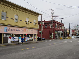
The Belmont Area is a retail and residential district running along SE Belmont St. in the inner Southeast section of Portland, Oregon in a parallel fashion to the Hawthorne District, 6 blocks to the south. From west to east the area extends 48 blocks, from SE 12th Ave. to SE 60th Ave., passing through the Buckman, Sunnyside, and Mount Tabor neighborhoods. The area is seven blocks wide, running from SE Belmont St. 4 blocks north to SE Stark St. and 3 blocks south to SE Salmon St. SE Belmont St. between SE 33rd Ave. and SE 35th Ave., in Sunnyside, is the heart of the district.

Foster-Powell is a neighborhood in the Southeast section of Portland, Oregon. The triangular neighborhood is bounded by three major transit arteries: Powell Boulevard to the north, Foster Road to the south, and 82nd Avenue to the east.
Montavilla is a neighborhood in the Northeast and Southeast sections of Portland, Oregon, United States, and contains an area east of Mount Tabor and west of Interstate 205, from the Banfield to SE Division. It is bordered by North Tabor, Mount Tabor, South Tabor, Madison South, Hazelwood, and Powellhurst-Gilbert.

Mount Tabor is an extinct volcanic vent with a city park on the volcano, located in Portland, Oregon's neighborhood of the same name. The name refers to Mount Tabor, Israel. It was named by Plympton Kelly, son of Oregon City pioneer resident Clinton Kelly.

César E Chávez Boulevard is a street in Portland, Oregon, United States. Until 2009, it was known as Northeast and Southeast 39th Avenue.
Burnside Street is a major thoroughfare of Portland, in the U.S. state of Oregon, and one of a few east–west streets that runs uninterrupted on both sides of the Willamette River. It serves as the dividing line between North Portland and South Portland. Its namesake bridge, Burnside Bridge, is one of the most heavily traversed in Portland. In Gresham between approximately the east 18300 block to Mt. Hood Hwy, Burnside runs southeast–northwest and is no longer the divide between northeast and southeast on the City of Portland-Multnomah County street grid. Additionally, SE Burnside St becomes NW Burnside Road at SE 202nd/NW Birdsdale Ave, and NE Burnside Rd at N Main Ave in Gresham. Burnside Road's eastern terminus is where it meets Mt. Hood Hwy (US-26), E Powell Blvd (US-26), and SE Powell Valley Road.

Oregon Hospital for the Insane was a facility constructed in the city of Portland, Oregon, USA by medical doctors J. C. Hawthorne and A. M. Loryea. Launched in 1859 as Oregon Hospital, the facility later came to specialize in the treatment of mental illness and served as the de facto insane asylum for the state of Oregon under contract with the Oregon Legislature beginning in 1861.
Northwest Portland is one of the sextants of Portland, Oregon, United States.

Southeast Portland is one of the sextants of Portland, Oregon.

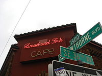
Hawthorne Boulevard is an east–west street in Portland, Oregon, and the dividing line between multiple neighborhoods, although "Hawthorne" is often itself considered its own neighborhood. The street stretches from the Willamette River on the west,, and 92nd Avenue on the east. Mount Tabor blocks the street between 60th Street and 72nd Avenue. Hawthorne Boulevard is a principal street west of 50th Avenue and a residential street to the east. The most famous portion of Hawthorne Boulevard is between 29th Avenue and Cesar Chavez Boulevard serving as a cultural hot spot for Portland's hippie movement. This section of the street is filled with local businesses, boutiques, restaurants, and gift stores, as well as the first Fred Meyer grocery at 36th and Hawthorne, and a bakery at 12th and Hawthorne. It the grocery closed in the 1930s. Hawthorne Boulevard is often compared to Haight Street in San Francisco due to the similar culture of both streets. The street is named for Doctor James C. Hawthorne, a politician and physician. Dr. Hawthorne donated land for the Oregon Hospital for the Insane near the modern day Colonel Summers Park in 1862. The Hospital for the Insane is often called the Hawthorne Asylum, and the street, originally named U Street, took on the moniker Asylum Avenue. The Asylum closed in 1883, and an ordinance was passed to rename the street to Hawthorne Avenue in 1888.