
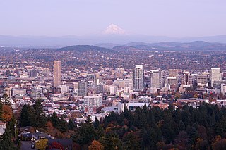
Portland is the largest and most populous city in the U.S. state of Oregon and the seat of Multnomah County. It is a major port in the Willamette Valley region of the Pacific Northwest, at the confluence of the Willamette and Columbia rivers. As of 2019, Portland had an estimated population of 654,741, making it the 26th most populated city in the United States and the second-most populous in the Pacific Northwest after Seattle. Approximately 2.4 million people live in the Portland metropolitan statistical area (MSA), making it the 25th most populous in the United States. Its combined statistical area (CSA) ranks 19th-largest with a population of around 3.2 million. Approximately 60% of Oregon's population resides within the Portland metropolitan area.

Oregon City is the county seat of Clackamas County, Oregon, United States, located on the Willamette River near the southern limits of the Portland metropolitan area. Established in 1829 by the Hudson's Bay Company, in 1844 it became the first U.S. city west of the Rocky Mountains to be incorporated.

Multnomah County is one of 36 counties in the U.S. state of Oregon. As of the 2010 United States Census, the county's population was 735,334. Its county seat, Portland, is the state's largest city. Multnomah County is part of the Portland-Vancouver-Hillsboro, OR-WA Metropolitan Statistical Area, and though smallest in area, it is the state's most populous county.

Portland International Airport is a joint civil–military airport and the largest airport in the U.S. state of Oregon that accounts for 90% of passenger air travel and more than 95% of air cargo of the state. It is within Portland's city limits just south of the Columbia River in Multnomah County, 6 miles by air and 12 mi (19 km) by highway northeast of downtown Portland. Portland International Airport is often referred to by its IATA airport code, PDX. The airport covers 3,000 acres of land.
The Portland metropolitan area or Greater Portland is a metropolitan area in the U.S. states of Oregon and Washington centered on the principal city of Portland, Oregon. The U.S. Office of Management and Budget (OMB) identifies it as the Portland–Vancouver–Hillsboro, OR–WA Metropolitan Statistical Area, a metropolitan statistical area used by the United States Census Bureau (USCB) and other entities. The OMB defines the area as comprising Clackamas, Columbia, Multnomah, Washington, and Yamhill Counties in Oregon, and Clark and Skamania Counties in Washington. The area's population is estimated at 2,753,168 in 2017.

Like transportation in the rest of the United States, the primary mode of local transportation in Portland, Oregon is the automobile. Metro, the metropolitan area's regional government, has a regional master plan in which transit-oriented development plays a major role. This approach, part of the new urbanism, promotes mixed-use and high-density development around light rail stops and transit centers, and the investment of the metropolitan area's share of federal tax dollars into multiple modes of transportation. In the United States, this focus is atypical in an era when automobile use led many areas to neglect their core cities in favor of development along interstate highways, in suburbs, and satellite cities.
Portland is "an international pioneer in transit orientated developments."
Dignity Village is a city-recognized legal encampment of an estimated 60 homeless people in Portland, Oregon, United States. In the days before Christmas of 2000, a group of transients in Portland established a tent city. It evolved from a group of self-described "outsiders" squatting a city owned land to a self-regulating, city-recognized campground as defined by Portland city code. The encampment is located on a land near Portland International Airport, and has elected community officials and constructed crude but functional cooking, social, electric, and sanitary facilities.

In the U.S. state of Oregon, U.S. Route 30, a major east–west U.S. Highway, runs from its western terminus in Astoria to the Idaho border east of Ontario. West of Portland, US 30 generally follows the southern shore of the Columbia River; east of Portland the highway has largely been replaced with Interstate 84, though it is signed all the way across the state, and diverges from the I-84 mainline in several towns, as a de facto business route. Out of all the states U.S. Route 30 traverses, it spends the most time in Oregon.

Kenton is a neighborhood in the north section of Portland, Oregon, United States. The neighborhood was originally a company town founded in 1911 for the Swift Meat Packing Company.
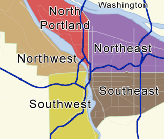
Portland, Oregon is divided into six sections, as of May 1, 2020: North Portland, Northeast Portland, Northwest Portland, South Portland, Southeast Portland, and Southwest Portland. There are 95 officially recognized neighborhoods, each of which is represented by a volunteer-based neighborhood association. No neighborhood associations overlap the Willamette River, but a few overlap the addressing sextants. For example, most addresses in the South Portland Neighborhood Association are South, but a portion of the neighborhood is west of SW View Point Terrace where addresses have a SW prefix. Similarly the Buckman Neighborhood Association spans both NE and SE Portland.

Concordia is a neighborhood in the Northeast section of Portland, Oregon, United States, named after Concordia University, which is located within it. The neighborhood borders are NE 22nd Ave. on the west, NE Columbia Blvd. on the north, and NE 42nd Ave. on the east. On the south, the border is NE Prescott St. and NE Alberta Ct., to the west and east of NE 33rd Ave., respectively. Neighborhoods bordering Concordia are Woodlawn, Vernon, and Sabin on the west, Sunderland on the north, Cully on the east, and Alameda and Beaumont-Wilshire on the south.
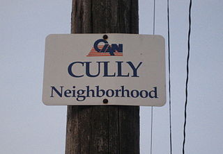
Cully is a neighborhood in the Northeast section of Portland, Oregon. The neighborhood, as well as NE Cully Blvd. that runs diagonally through it, is named after English stonemason Thomas Cully (1810–1891), an early settler. Cully borders Sunderland, Concordia, and Beaumont-Wilshire on the west, Portland International Airport on the north, Sumner on the east, and Rose City Park and Roseway on the south.
East Columbia is a neighborhood in North and Northeast Portland, Oregon, consisting of a main area west and north of the Sunderland neighborhood, and a smaller disconnected exclave on the Columbia River south of Hayden Island and east of Bridgeton.
Overlook is a neighborhood in the North section of Portland, Oregon on the east shore of the Willamette River. It borders University Park and Arbor Lodge on the north, Humboldt and Boise on the east, Eliot on the southeast, and Northwest Industrial and the Northwest District across the Willamette on the west.
University Park is a neighborhood in the north section of Portland, Oregon on the east shore of the Willamette River. University Park is bounded by North Lombard Street and the Portsmouth neighborhood to the north, North Chautauqua Boulevard and the Arbor Lodge neighborhood to the east, The Willamette River and Mock's Bottom industrial area to the south, and the North Portland railroad cut with Cathedral Park and St. Johns neighborhoods to the west.
Sumner is a neighborhood in the Northeast section of Portland, Oregon, including the portion of the city of Maywood Park west of Interstate 205. The area includes Portland International Airport at its northern extreme but there are no residences surrounding it. Also the area north of Columbia Blvd. is industrial and commercial, though it does contain a few hotels.
Parkrose is a neighborhood in the Northeast section of Portland, Oregon, and is considered part of East Portland. It is bordered by Sumner to the west, the Columbia River to the north, Argay to the east, and Parkrose Heights and the city of Maywood Park to the south. Sandy Boulevard crosses the neighborhood, with a primarily industrial area prevailing to the north and primarily residential area to the south.
Interstate 5 (I-5) in the U.S. state of Oregon is a major Interstate Highway that traverses the state from north to south. It travels to the west of the Cascade Mountains, connecting Portland to Salem, Eugene, Medford, and other major cities in the Willamette Valley and across the northern Siskiyou Mountains. The highway runs 308 miles (496 km) from the California state line near Ashland to the Washington state line in northern Portland, forming the central part of Interstate 5's route between Mexico and Canada.
Interstate 84 (I-84) in the U.S. state of Oregon is a major Interstate Highway that traverses the state from west to east. It is concurrent with U.S. Route 30 (US 30) for most of its length and runs 376 miles (605 km) from an interchange with I-5 in Portland to the Idaho state line near Ontario. The highway roughly follows the Columbia River and historic Oregon Trail in northeastern Oregon, and is designated as part of Columbia River Highway No. 2 and all of the Old Oregon Trail Highway No. 6; the entire length is also designated as the Vietnam Veterans Memorial Highway. I-84 intersects several of the state's main north–south roads, including US 97, US 197, I-82, and US 395.

Irving Park is a city park of about 16 acres (6.5 ha) in northeast Portland, in the U.S. state of Oregon. Located at Northeast 7th Avenue and Fremont Street in the Irvington neighborhood, the park is on land that was originally owned by William Irving, for whom the neighborhood was named. The Irvington Racetrack once occupied part of the land.
