Related Research Articles
Eastmoreland is an early-twentieth century, tree-filled neighborhood in inner southeast Portland, Oregon, United States. Eastmoreland was named for a local real estate developer, Judge J.C. Moreland.

The Sellwood Bridge is a deck arch bridge that spans the Willamette River in Portland, Oregon, in the United States. The current bridge opened in 2016 and replaced a 1925 span that had carried the same name. The original bridge was Portland's first fixed-span bridge and, being the only river crossing for miles in each direction, the busiest two-lane bridge in Oregon. The Sellwood Bridge links the Sellwood and Westmoreland neighborhoods of Portland on the east side with Oregon Route 43/Macadam Avenue on the west side. At its east end it leads to Tacoma Street. The bridge is owned and operated by Multnomah County. The original span of 1925 was a steel truss bridge, while its 2016 replacement is a deck-arch-type bridge.
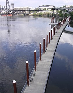
The Eastbank Esplanade is a pedestrian and bicycle path along the east shore of the Willamette River in Portland, Oregon, United States. Running through the Kerns, Buckman, and Hosford-Abernethy neighborhoods, it was conceived as an urban renewal project to rebuild the Interstate 5 bicycle bypass washed out by the Willamette Valley Flood of 1996. It was renamed for former Portland mayor Vera Katz in November 2004 and features a statue of her near the Hawthorne Bridge.
Sellwood-Moreland is a neighborhood on a bluff overlooking the Willamette River in Southeast Portland, Oregon, bordering Brooklyn to the north, Eastmoreland to the east, and the city of Milwaukie to the south. The neighborhood is linked to Southwest Portland across the Willamette River by the Sellwood Bridge, the southernmost of Portland's bridges.

Oregon's 3rd congressional district covers most of Multnomah County, including Gresham, Troutdale, and most of Portland east of the Willamette River. It also includes the northeastern part of Clackamas County and all of Hood River County. Generally, most of Portland east of the Willamette River is in the 3rd District.

The Springwater Corridor Trail is a bicycle and pedestrian rail trail in the Portland metropolitan area in Oregon, United States. It follows a former railway line from Boring through Gresham to Portland, where it ends south of the Eastbank Esplanade. Most of the corridor, about 21 miles (34 km) long, consists of paved, off-street trail, though about 1 mile (1.6 km) overlaps city streets in Portland's Sellwood neighborhood. A large segment roughly follows the course of Johnson Creek and crosses it on bridges many times. Much of the corridor was acquired by the City of Portland in 1990; remaining segments were acquired by Metro thereafter.
The 40-Mile Loop is a partially completed greenway trail around and through Portland in the U.S. state of Oregon. It was proposed in 1903 by the Olmsted Brothers architecture firm as part of the development of Forest Park. One greenway expert calls it "one of the most creative and resourceful greenway projects in the country."
John Sellwood was a pioneer Episcopal minister who settled in the U.S. state of Oregon on a 321-acre (130 ha) donation land claim on the east bank of the Willamette River upstream from Portland.
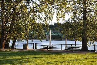
Oaks Bottom Wildlife Refuge is a city park of about 141 acres (57 ha) in southeast Portland, in the U.S. state of Oregon. Located in a floodplain along the east bank of the Willamette River near Sellwood, the park is known for attracting a wide variety of birds. In 1988, the park was named Portland's first wildlife refuge, and in 2004, it was designated the city's first migratory bird park.

The Willamette Valley is a 150-mile (240 km) long valley in Oregon, in the Pacific Northwest region of the United States. The Willamette River flows the entire length of the valley, and it is surrounded by mountains on three sides – the Cascade Range to the east, the Oregon Coast Range to the west, and the Calapooya Mountains to the south.

The Bybee Bridge is a bridge over McLoughlin Boulevard in southeast Portland, Oregon connecting the Eastmoreland and Sellwood neighborhoods. The bridge is named after James Francis Bybee.

The Sellwood–Moreland Library is a branch of the Multnomah County Library, in the Sellwood neighborhood of Portland in the U.S. state of Oregon. First established in 1905 as the Sellwood Reading Room, it operated in several Sellwood locations before re-opening in 2002 in a new mixed-use building at S.E. 13th Avenue and Bidwell Street.
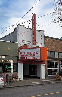
Moreland Theater is a single-screen movie theater located in the Sellwood neighborhood of Portland, Oregon in the United States.

Julius Caesar Moreland was an Oregon pioneer, a successful lawyer, and a judge based in Portland, Oregon. He was also Clerk of the Oregon Supreme Court in Salem in the early 20th century. He is the namesake of the Eastmoreland, Westmoreland, and Sellwood – Moreland neighborhoods.

Southeast Bybee Boulevard is a light rail station in Portland, Oregon, United States, served by TriMet as part of the MAX Light Rail system. Situated between the Southeast Tacoma/Johnson Creek and Southeast 17th Avenue and Holgate Boulevard stations, it is the 14th station southbound on the Orange Line, which operates between downtown Portland, Southeast Portland, and Milwaukie. The station's entrances are located on the Bybee Bridge, which spans Southeast McLoughlin Boulevard, the light rail tracks, and Union Pacific Railroad (UP) freight tracks and connects Portland's Sellwood-Moreland and Eastmoreland neighborhoods. The grade-separated island platform station adjoins Eastmoreland Golf Course and Crystal Springs Rhododendron Garden to the east and Westmoreland's park of the same name to the west.
The Bee is a newspaper based in Sellwood, a neighborhood of Portland in the U.S. state of Oregon. It was founded as the Sellwood Bee in 1906, and at various times has been known as Bee, the Milwaukee Bee, and the Sellwood-Moreland Bee. It returned to simply the Bee in 1970, and has retained the name since.

Baes Fried Chicken, or Baes Chicken, is a fried chicken restaurant with two locations in Portland, Oregon.
Philadelphia's Steaks and Hoagies is a restaurant with multiple locations in the U.S. state of Oregon. There are two restaurants in the Portland metropolitan area and another in Sisters.
Papa Haydn is a restaurant with two locations in Portland, Oregon.
PDX Sliders is a restaurant with two locations in Portland, Oregon.
References
- ↑ Evans-Hatch, Gail E.H.; Evans-Hatch, D. Michael (1999). "The Development of Sellwood-Moreland" (PDF). Evans-Hatch & Associates. Archived from the original (pdf) on February 5, 2015. Retrieved February 4, 2015.