
Vanport, sometimes referred to as Vanport City or Kaiserville, was a city of wartime public housing in Multnomah County, Oregon, United States, between the contemporary Portland city boundary and the Columbia River. It was destroyed in the 1948 Columbia River flood and not rebuilt. It sat on what is currently the site of Delta Park and the Portland International Raceway.
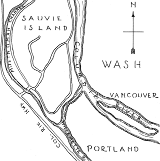
Sauvie Island is in the U.S. state of Oregon, originally named as Wapato Island or Wappatoo Island. It is the largest island along the Columbia River, at 24,000 acres (9,712 ha), and one of the largest river islands in the United States. It lies approximately 10 miles (16 km) northwest of downtown Portland, between the Columbia River to the east, the Multnomah Channel to the west, and the Willamette River to the south. A large portion of the island is designated as the Sauvie Island Wildlife Area. Sturgeon Lake, in the north central part of the island, is the most prominent water feature. The land area is 39.25 square miles (101.7 km2), or 25,120 acres (10,170 ha). Most of the island is in Multnomah County, but the northern third is in Columbia County. The Wapato Bridge provides access across the Multnomah Channel from U.S. Route 30 and was completed in June 2008, replacing the first bridge to connect the island to the mainland which was opened on December 30, 1950.

The Interstate Bridge is a pair of nearly identical steel vertical-lift, Parker through-truss bridges that carry Interstate 5 traffic over the Columbia River between Vancouver, Washington and Portland, Oregon in the United States.

Governor Tom McCall Waterfront Park is a 36.59-acre (148,100 m2) park located in downtown Portland, Oregon, along the Willamette River. After the 1974 removal of Harbor Drive, a major milestone in the freeway removal movement, the park was opened to the public in 1978. The park covers 13 tax lots and is owned by the City of Portland. The park was renamed in 1984 to honor Tom McCall, the Oregon governor who pledged his support for the beautification of the west bank of the Willamette River—harkening back to the City Beautiful plans at the turn of the century which envisioned parks and greenways along the river. The park is bordered by RiverPlace to the south, the Steel Bridge to the north, Naito Parkway to the west, and Willamette River to the east. In October 2012, Waterfront Park was voted one of America's ten greatest public spaces by the American Planning Association.

The MAX Yellow Line is a light rail line serving Portland, Oregon, United States. Operated by TriMet as part of the MAX Light Rail system, it connects North Portland, Portland City Center, and Portland State University (PSU). The line serves 17 stations; it runs north–south from Expo Center station to PSU South/Southwest 6th and College station, interlining with the Green and Orange lines within the Portland Transit Mall. Service runs for 21 hours per day with headways of up to 15 minutes. The Yellow Line is the fourth-busiest service in the MAX system; it carried an average 12,960 riders per weekday in September 2019.
Kenton is a neighborhood in the north section of Portland, Oregon, United States. The neighborhood was originally a company town founded in 1911 for the Swift Meat Packing Company.
Harbor Drive is a short roadway in Portland, Oregon, spanning a total length of 0.7 miles (1.1 km), which primarily functions as a ramp to and from Interstate 5. It was once much longer, running along the western edge of the Willamette River in the downtown area. Originally constructed from 1942–43, the vast majority of the road was replaced with Tom McCall Waterfront Park in the 1970s. Signed as U.S. Route 99W, it had been the major route through the city and its removal is often cited as the first instance of freeway removal in the U.S. and as a milestone in urban planning; the original road is remembered as the first limited-access highway built in the city.

Government Island is a 1,760-acre (710 ha) island in the Columbia River north of Portland, in Multnomah County, in the U.S. state of Oregon. Though Interstate 205 passes over it on the Glenn L. Jackson Memorial Bridge, access to the island is only by boat. There is a city controlled locked gate in the fence surrounding the freeway.

Jantzen Beach Amusement Park was a popular amusement park from 1928 to 1970 in Portland, Oregon, on Hayden Island in the middle of the Columbia River. "The Coney Island of the West" opened on May 26, 1928 as the largest amusement park in the nation, covering over 123 acres (50 ha) at the northern tip of Portland.

Lotus Isle Amusement Park was an amusement park that operated from 1930 to 1932 on Tomahawk Island in Portland, Oregon. Known as the "Wonderland of the Pacific Northwest", Lotus Isle was located just east of the more successful Jantzen Beach Amusement Park. Lotus Isle spread out over 128 acres (0.52 km2) and at the time was Portland's largest amusement park.

The Swan Island Municipal Airport was a joint civil-military airport that was operational on Swan Island in Portland, Oregon. Though it officially opened in 1927, the United States Postal Service had been using the airfield for a year. After the Portland–Columbia Super Airport was completed in the late 1930s, Swan Island Municipal Airport had little use since its runways were too small for newer aircraft and the low altitude made takeoffs and landings difficult. The airport was operational for nearly two decades, but due in part to the advances in aviation, it became obsolete soon after its construction. During World War II, a Kaiser shipyard was located at Swan Island. The shipbuilding facilities were acquired by the Port of Portland after the war.
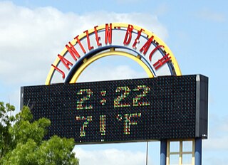
Jantzen Beach Center is an outdoor shopping mall located in Portland, Oregon, on Hayden Island in the Columbia River, known as Jantzen Beach SuperCenter from 1996 until about 2012. Opened in 1972 as an indoor mall, sometimes known informally as Jantzen Beach Mall, it was largely torn down in 1995–96 for big box development. The remaining enclosed portion included Ross Dress for Less, Burlington Coat Factory and Target as its anchor stores until April 2012, when renovation work began. A new one-story Target store was constructed on the property over the site of a former Barnes & Noble bookstore and restaurant, opening in October 2012.

Interstate 5 (I-5) in the U.S. state of Oregon is a major Interstate Highway that traverses the state from north to south. It travels to the west of the Cascade Mountains, connecting Portland to Salem, Eugene, Medford, and other major cities in the Willamette Valley and across the northern Siskiyou Mountains. The highway runs 308 miles (496 km) from the California state line near Ashland to the Washington state line in northern Portland, forming the central part of Interstate 5's route between Mexico and Canada.
KBMS is a radio station broadcasting an urban adult contemporary format. Licensed to Vancouver, Washington, United States, it serves the Portland, Oregon area. The studios are in Vancouver, while the transmitter site is in North Portland at the Smith and Bybee Refuge.

Vancouver is a city on the north bank of the Columbia River in the U.S. state of Washington, located in Clark County. Founded in 1825 and incorporated in 1857, Vancouver had a population of 190,915 as of the 2020 census, making it the fourth-most populous city in Washington state. Vancouver is the seat of government of Clark County and forms part of the Portland-Vancouver metropolitan area, the 25th-largest metropolitan area in the United States. Originally established in 1825 around Fort Vancouver, a fur-trading outpost, the city is located on the Washington–Oregon border along the Columbia River, directly north of Portland.

The Oregon Slough Railroad Bridge, also known as the BNSF Railway Bridge 8.8, is a swing-span, through truss bridge in Portland, Oregon, United States. Currently owned and operated by BNSF Railway, it crosses an anabranch of the Columbia River known as North Portland Harbor and historically as the Oregon Slough. The bridge's northern end is on Hayden Island, which, along with Tomahawk Island, forms the north shore of the channel. Completed in 1908, the two-track bridge is one of only two swing bridges surviving in Portland, which once had several bridges of that type, both for road and rail traffic. The only other remaining swing bridge in the Portland area is another rail-only bridge on the same line, BNSF's nearby Bridge 9.6, spanning the Columbia River.
Jantzen Beach Seaplane Base was a private seaplane base and airport located on Hayden Island in Portland, Oregon, United States. It featured a mile long landing area on the Columbia River and a 3,000 foot by 300 foot gravel runway. The park was owned and operated by the Jantzen Beach Amusement Park. When the park was converted into the Jantzen Beach SuperCenter the seaplane base and airport were removed.

The North Portland Harbor is an Oregon waterway or channel in Multnomah County, specifically in Portland. An anabranch, about 5 miles (8 km) long, of the Columbia River, it separates Hayden and Tomahawk islands from the mainland. Flowing generally northwest, the channel rejoins the main stem slightly upstream of Kelley Point Park and the mouth of the Willamette River.

Swan Island is located on the Willamette River about 4.5 miles (7.2 km) downriver from downtown Portland, Oregon, United States. Although presently connected to the Willamette's east bank by land fill, it existed as a river island under natural conditions.
The Holiday Inn Portland-Columbia Riverfront is a hotel in Portland, Oregon. The hotel is located on Hayden Island, along the Columbia River east of the Interstate Bridge. Construction cost $18 million.


